Fraud Blocker Skip to main content

Barclay Street Collection

"Barclay Street: A Journey Through Time and Space" Step back in time to 1850

Background imageBarclay Street Collection: Sunderland SR6 0 Map

Sunderland SR6 0 Map
Postcode Sector Map of Sunderland SR6 0

Background imageBarclay Street Collection: A Panoramic View of Broadway, from the Astor House to Worth Street, in 1850 (litho)

A Panoramic View of Broadway, from the Astor House to Worth Street, in 1850 (litho)
5215011 A Panoramic View of Broadway, from the Astor House to Worth Street, in 1850 (litho) by American School, (19th century); Private Collection; (add.info.: A Panoramic View of Broadway)

Background imageBarclay Street Collection: Sedgemoor TA6 5 Map

Sedgemoor TA6 5 Map
Postcode Sector Map of Sedgemoor TA6 5

Background imageBarclay Street Collection: Staffordshire ST3 1 Map

Staffordshire ST3 1 Map
Postcode Sector Map of Staffordshire ST3 1

Background imageBarclay Street Collection: Liverpool L8 4 Map

Liverpool L8 4 Map
Postcode Sector Map of Liverpool L8 4

Background imageBarclay Street Collection: Leicester LE3 0 Map

Leicester LE3 0 Map
Postcode Sector Map of Leicester LE3 0

Background imageBarclay Street Collection: Fife KY4 9 Map

Fife KY4 9 Map
Postcode Sector Map of Fife KY4 9

Background imageBarclay Street Collection: West Dunbartonshire G60 5 Map

West Dunbartonshire G60 5 Map
Postcode Sector Map of West Dunbartonshire G60 5

Background imageBarclay Street Collection: Glasgow G21 4 Map

Glasgow G21 4 Map
Postcode Sector Map of Glasgow G21 4

Background imageBarclay Street Collection: UK Maps, AB Aberdeen, AB39 2

UK Maps, AB Aberdeen, AB39 2
AB39 2

Background imageBarclay Street Collection: BARCLAY-VESEY BUILDING. The Barclay-Vesey Building in Lower Manhattan. Photograph

BARCLAY-VESEY BUILDING. The Barclay-Vesey Building in Lower Manhattan. Photograph, c1926

Background imageBarclay Street Collection: Plate 7: Map bounded by Murray Street, Broadway, Dey Street, West Street; Including

Plate 7: Map bounded by Murray Street, Broadway, Dey Street, West Street; Including Robinson Street, Park Place, Barclay Street, Vesey Street, Fulton Street, Washington Street, Greenwich Street

Background imageBarclay Street Collection: 3rd Ward. Plate 6: Map bounded by Fulton Street, Greenwich Street, Barclay Street

3rd Ward. Plate 6: Map bounded by Fulton Street, Greenwich Street, Barclay Street, College Place, Park Place, Broadway; Including Vesey Street, Church Street

Background imageBarclay Street Collection: 3rd Ward. Plate 3: Map bounded by West Street, Robinson Street, College Place, Barclay

3rd Ward. Plate 3: Map bounded by West Street, Robinson Street, College Place, Barclay Street, Greenwich Street, Courtland Street; Including Washington Street, Dey Street, Fulton Street, Vesey Street

Background imageBarclay Street Collection: Plate 2: Bounded by East River Vernon Avenue, Boulevard, Fulton Avenue, Mill Street

Plate 2: Bounded by East River Vernon Avenue, Boulevard, Fulton Avenue, Mill Street, Orchard Street, Boulevard, Hoyt Avenue, Barclay Street, Woolsey Avenue, Rapelje Avenue and Freeman Avenue

Background imageBarclay Street Collection: Plate 9: Map bounded by Greenwich Street, Barclay Street, College Place, West Broadway

Plate 9: Map bounded by Greenwich Street, Barclay Street, College Place, West Broadway, Reade Street, Broadway, Vesey Street. 1852, 1854, William Perris, New York, N.Y. USA

Background imageBarclay Street Collection: Plate 8: Map bounded by West Street, Reade Street, Hudson Street, College Place

Plate 8: Map bounded by West Street, Reade Street, Hudson Street, College Place, Barclay Street, Greenwich Street, Vessey Street. 1852, 1854, William Perris, New York, N.Y. USA

Background imageBarclay Street Collection: Skyscrapers on Barclay Street

Skyscrapers on Barclay Street, Lower Manhattan, New York City, New York, United States of America, North America


All Professionally Made to Order for Quick Shipping

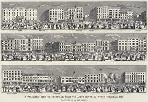
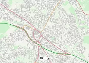
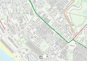
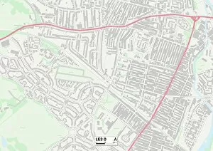
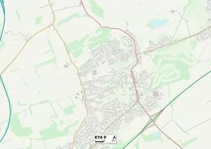
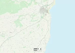
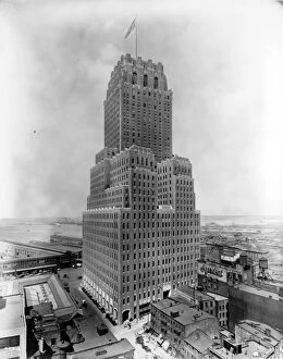
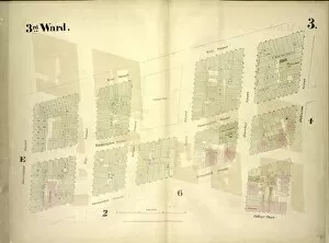
"Barclay Street: A Journey Through Time and Space" Step back in time to 1850, where a litho painting captures the panoramic view of Broadway from the Astor House to Worth Street. The bustling energy of this historic street is palpable, with horse-drawn carriages and pedestrians filling its sidewalks. Fast forward to modern times, and they are be found on maps like Sunderland SR6 0, Sedgemoor TA6 5, Staffordshire ST3 1, Liverpool L8 4, Leicester LE3 0, Fife KY4 9, West Dunbartonshire G60 5, Glasgow G21 4. It stretches across different regions of the UK but remains a significant landmark in each location. In Lower Manhattan stands the iconic Barclay-Vesey Building. This architectural marvel has become synonymous with the neighborhood's skyline. Its grandeur captivates passersby as they gaze up at its towering presence. Plate7 showcases a map bounded by Murray Street, Broadway, Dey Street, and West Street—an area that includes Barclay Street. This map offers insights into the surrounding streetscape and highlights how Barclay plays an integral role within this vibrant cityscape. Whether you're exploring Aberdeen or AB39 2 in the UK or admiring photographs of Lower Manhattan's landmarks like the Barclay-Vesey Building—Barclay Street continues to leave an indelible mark on both historical records and contemporary urban landscapes alike. So take a stroll down memory lane or navigate through modern maps; let your imagination wander along this storied street that connects people across time and space.