mail_outline sales@mediastorehouse.com
Framed Print
Canvas Print
Metal Print
Photographic Print
Poster Print
Fine Art Print
Jigsaw Puzzle
Photo Mug
Greetings Card
Cushion
Mouse Mat
Water vapour maps of Antarctica, 2004Water vapour maps of Antarctica. Satellite images of the increase in water vapour over Antarctica from 13 August to 14 October 2004 (the austral spring)
Sun tan oil aerosol use, 1950s C018 / 0641Sun tan oil aerosol use. Woman spraying sun tan oil on herself on a beach while sunbathing. This is an example of the use of Freon in aerosols
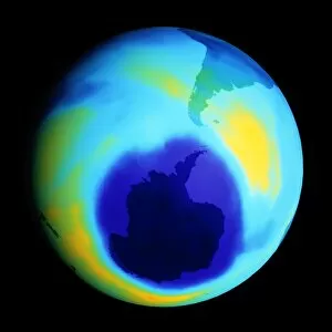
Ozone hole, September 2001Antarctic ozone hole. Coloured satellite image of reduced atmospheric ozone levels around Antarctica (lower centre, darkest blue) on 17 September 2001
Antarctic ozone hole, 2006Antarctic ozone hole. Coloured satellite image of the reduced atmospheric ozone layer over Antarctica on 13th September 2007
Global pollution, conceptual imageGlobal pollution. Conceptual image of pollution enveloping the Earth, representing global levels of pollutants such as nitrogen oxides, chlorofluorocarbons (CFCs), heavy metals, and greenhouse gases
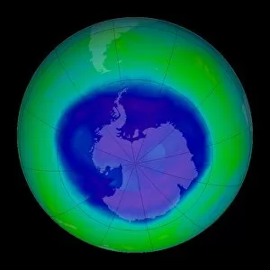
Antarctic ozone hole, 2009Antarctic ozone hole. Satellite image of the ozone hole (blue) over Antarctica (centre) on 10th September 2009. Ozone layer thicknesses are colour coded from purple (lowest) through blue
Green balloon and climate change, conceptual artwork. This image represents the wide variety of environmental issues affecting Earths atmosphere
Antarctic ozone hole maximum, 2008Antarctic ozone hole maximum. Satellite image of the maximum extent in 2008 of the ozone hole (blue) over Antarctica (centre)
Ozone hole prediction. Computer model showing Antarctic ozone levels from 1974 to 2054 if chlorofluorocarbons (CFCs), the chemicals widely blamed for destroying ozone