Fraud Blocker Skip to main content

Coastline Collection

"Discovering the Beauty of Coastlines

Background imageCoastline Collection: Scotland, Orkney Islands, Skara Brae Prehistoric Village

Scotland, Orkney Islands, Skara Brae Prehistoric Village. Skara Brae, a stone-built Neolithic settlement, located on the Bay of Skaill on the west coast of Mainland Orkney

Background imageCoastline Collection: Landscape: Moeraki boulders at sunset, Otago peninsula, New Zealand

Landscape: Moeraki boulders at sunset, Otago peninsula, New Zealand
Moeraki boulders at sunset, Otago peninsula, New Zealand

Background imageCoastline Collection: Deep Creek at William National Park, Bay of Fires, Tasmania

Deep Creek at William National Park, Bay of Fires, Tasmania

Background imageCoastline Collection: Tower of Hercules, CoruAna, Galicia, Spain

Tower of Hercules, CoruAna, Galicia, Spain
The Tower of Hercules (Torre de Hercules) is an ancient Roman lighthouse. Since June 27, 2009, has been a UNESCO World Heritage Site

Background imageCoastline Collection: Coast at Claddaghduff with Omey Island, Connemara, County Galway, Republic of Ireland, Europe

Coast at Claddaghduff with Omey Island, Connemara, County Galway, Republic of Ireland, Europe

Background imageCoastline Collection: Map of Cyprus, published in 1880

Map of Cyprus, published in 1880
Ancient map of Cyprus. Lithograph, published in 1880

Background imageCoastline Collection: Political Map of Africa

Political Map of Africa
Vector Illustration of the policital map of Africa Reference map as created by the US Central Intelligence Agency

Background imageCoastline Collection: A Kingston Norfolk Island view, part of the restored British penal colony buildings

A Kingston Norfolk Island view, part of the restored British penal colony buildings and now a world heritage listed area

Background imageCoastline Collection: Tidal River at Wilsons Promontory, Victoria

Tidal River at Wilsons Promontory, Victoria. Wilsons Promontory National Park Fondly known as ‘The Prom, Wilsons Promontory is one of Victoria's best loved national parks

Background imageCoastline Collection: Map of Portugal

Map of Portugal
Antique illustration engraving map og Portugal

Background imageCoastline Collection: Picture No. 10741261

Picture No. 10741261
Portland Bill, Isle of Portland, Dorset, England Date:

Background imageCoastline Collection: Picture No. 10741258

Picture No. 10741258
Lyme Regis, showing The Cobb, the harbour wall, coastal town, Lyme Bay, Dorset Date:

Background imageCoastline Collection: Majorca The port & marina viewed from the pine walk, Polenca

Majorca The port & marina viewed from the pine walk, Polenca
DAD-957 MAJORCA - Pollensa (Pollenca) The port & marina viewed from the pine walk David C Dixon Please note that prints are for personal display purposes only and may not be reproduced in any way

Background imageCoastline Collection: The wreck of the collier Bessie, with all that remains of the wrecked Vulture in the surf beyond

The wreck of the collier Bessie, with all that remains of the wrecked Vulture in the surf beyond, Carbis Bay, Lelant
A view of the Bessie wrecked at Carbis Bay, broadside to the surf, with the machinery of the Vulture beyond. SS Bessie (ON 49984) was an iron three masted brigantine rigged steamer of 287 tons gross

Background imageCoastline Collection: View of Old Town City of Dubrovnik

View of Old Town City of Dubrovnik
Dubrovnik is one of the most prominent tourist destinations in the Mediterranean Sea, a seaport on the Dalmation coast. In 1979, the city of Dubrovnik joined the UNESCO list of World Heritage Sites

Background imageCoastline Collection: Art Deco Burgh Island Hotel

Art Deco Burgh Island Hotel
Burgh Island is a small tidal island on the coast of South Devon. There are several buildings on the island, the largest being the Art Deco Burgh Island Hotel

Background imageCoastline Collection: Elevated view of famous shipwreck beach. Zakynthos, Greek Islands, Greece

Elevated view of famous shipwreck beach. Zakynthos, Greek Islands, Greece

Background imageCoastline Collection: Bay in Sound of Taransay - Harris - Outer Hebrides - Scotland

Bay in Sound of Taransay - Harris - Outer Hebrides - Scotland
GET-1860 Bay in Sound of Taransay - Harris - Outer Hebrides - Scotland Geoff Trinder Please note that prints are for personal display purposes only and may not be reproduced in anyway

Background imageCoastline Collection: Ireland AL 2367 Dingle peninsula © Ake Lindau / ARDEA LONDON

Ireland AL 2367 Dingle peninsula © Ake Lindau / ARDEA LONDON
AL-2367 Ireland, The Dingle peninsula Ake Lindau Please note that prints are for personal display purposes only and may not be reproduced in any way

Background imageCoastline Collection: A view of the coastline at Swanage, Dorset, England, United Kingdom

A view of the coastline at Swanage, Dorset, England, United Kingdom

Background imageCoastline Collection: UK JLM 10277 Flamborough Head, Yorkshire. © John Mason / ARDEA LONDON

UK JLM 10277 Flamborough Head, Yorkshire. © John Mason / ARDEA LONDON
JLM-10277 YORKSHIRE - Flamborough Head, UK John Mason Please note that prints are for personal display purposes only and may not be reproduced in any way

Background imageCoastline Collection: Rock, St Minver, Cornwall. June 1906

Rock, St Minver, Cornwall. June 1906
A view of Rock looking down the estuary at low tide. On the foreshore, to the left, is a bait digger with his fork and basket. To the right is a fishing boat, moored with its sails down

Background imageCoastline Collection: UK - aerial of Wells-next-the-sea, salt marsh landscape & coastline at low tide. Norfolk, UK

UK - aerial of Wells-next-the-sea, salt marsh landscape & coastline at low tide. Norfolk, UK
CK-4234 NORFOLK - Aerial of Wells-next-the-Sea. Salt marsh landscape and coastline at low tide Norfolk Broads, North Norfolk

Background imageCoastline Collection: Polzeath, St Minver, Cornwall. Late 1930s

Polzeath, St Minver, Cornwall. Late 1930s
Taken from the the south western side of Polzeath looking north easterly towards the main village area. Cars are parked on the beach with people enjoying a sunny summers day in the late 1930s

Background imageCoastline Collection: A Merlin HM Mk1 helicopter from 829 Naval Air Squadron, based at RNAS Culdrose, flying

A Merlin HM Mk1 helicopter from 829 Naval Air Squadron, based at RNAS Culdrose, flying over the Cornish coastline. This image was submitted as part of the Peregrine 06 Photographic Competition

Background imageCoastline Collection: The Bathurst Lighthouse

The Bathurst Lighthouse at Rottnest Island, Western Australia

Background imageCoastline Collection: Lundy UK - low spring tide on Bristol Channel

Lundy UK - low spring tide on Bristol Channel
ROG-6508 LUNDY Island - coastline at low spring tide Bristol Channel Edge, Marine Nature Reserve. Lundy Bob Gibbons Please note that prints are for personal display purposes only

Background imageCoastline Collection: Map of Italy, 1902. Creator: Unknown

Map of Italy, 1902. Creator: Unknown
Map of Italy, 1902. Showing the various administrative regions, the islands of Sardinia and Sicily, with inset of Rome. From The Century Atlas of the World. [John Walker & Co, Ltd. London, 1902]

Background imageCoastline Collection: Political map of The Middle East

Political map of The Middle East
Vector illustration of the policital map of The Middle East Reference map was created by the US Central Intelligence Agency

Background imageCoastline Collection: Scarborough, 1909. Artist: JMW Turner

Scarborough, 1909. Artist: JMW Turner
Scarborough, 1909. From The Water-colours of J. M. W. Turner, text by W. G. Rawlinson and A. J. Finberg. [Avalon Press, London, 1909]

Background imageCoastline Collection: Whitefish Point Lighthouse by Moonlight

Whitefish Point Lighthouse by Moonlight
The Whitefish Point Lighthouse illumintated by moonlight. Whitefish Point is located at the extreme southeastern end of Lake Superior

Background imageCoastline Collection: Shoal Bay

Shoal Bay
View of Shoal Bay from Mount Tomaree, New South Wales

Background imageCoastline Collection: Map of Antarctica overlaid with illustrations of Sea Gulls, Penguins, Elephant Seal

Map of Antarctica overlaid with illustrations of Sea Gulls, Penguins, Elephant Seal, Shrimp and buildings

Background imageCoastline Collection: Abanoned tin mine at Wheal Coates, Cornwall, UK

Abanoned tin mine at Wheal Coates, Cornwall, UK
This abandoned structure used to house a water pumping engine that was used in the mining process

Background imageCoastline Collection: Northern Irish coastline with wide sandy beaches in Ballycastle, County Antrim, Northern Ireland

Northern Irish coastline with wide sandy beaches in Ballycastle, County Antrim, Northern Ireland, United Kingdom, Europe

Background imageCoastline Collection: Portbradden, Antrim Coast, County Antrim, Northern Ireland, United Kingdom, Europe, PublicGround

Portbradden, Antrim Coast, County Antrim, Northern Ireland, United Kingdom, Europe, PublicGround

Background imageCoastline Collection: Aerial view - Sandbanks, Poole Bay, Dorset DW2000

Aerial view - Sandbanks, Poole Bay, Dorset DW2000
AW-6601 Aerial view - Sandbanks, Poole Bay, Dorset UK Adrian Warren contact details: prints@ardea.com tel: +44 (0) 20 8318 1401

Background imageCoastline Collection: Matthew Pariss Map of Great Britain showing rivers & towns in the south of England & part of

Matthew Pariss Map of Great Britain showing rivers & towns in the south of England & part of Wales, c. 1250 (1944)
Many place-names are still recognisable today. The word Auster, written over the English Channel at the bottom, refers to wind bringing heavy cloud cover and fog

Background imageCoastline Collection: Reverend Hawkers Hut, Morwenstow, Cornwall. 9th July 1913

Reverend Hawkers Hut, Morwenstow, Cornwall. 9th July 1913
A man inside Hawkers Hut on the cliffs close to Sharpnose Point, about a mile from Morwenstow. It was built by the eccentric clergyman, poet and antiquarian Robert Stephen Hawker (1803-1875)

Background imageCoastline Collection: Pink-footed goose

Pink-footed goose
A photograph of an original hand-colored engraving from The History of British Birds by Morris published in 1853-1891

Background imageCoastline Collection: Hastings, 19th century (1910). Artist: JMW Turner

Hastings, 19th century (1910). Artist: JMW Turner
Hastings, 19th century (1910). From The Connoisseur magazine (September 1910)

Background imageCoastline Collection: Northern Friesland (Nordfriesland), and islands, Schleswig-Holstein, Germany, lithograph

Northern Friesland (Nordfriesland), and islands, Schleswig-Holstein, Germany, lithograph, published 1887
North Frisian Islands and Northern Friesland (Nordfriesland), the northernmost district of Germany, part of the state of Schleswig-Holstein. Lithograph, published in 1887

Background imageCoastline Collection: London to Penzance train at Teignmouth, Devon

London to Penzance train at Teignmouth, Devon
London to Penzance train on the seafront track at Teignmouth, Devon. Date: circa 1960s

Background imageCoastline Collection: Ladram Bay near Sidmouth, Devon

Ladram Bay near Sidmouth, Devon. Date: 1936

Background imageCoastline Collection: Sunrise at Tacking Point Lighthouse

Sunrise at Tacking Point Lighthouse
Port Macquarie, NSW, Australia

Background imageCoastline Collection: Canal D Amour beach near Sidari, Corfu, Greece

Canal D Amour beach near Sidari, Corfu, Greece

Background imageCoastline Collection: View of Four Mile Beach, Port Douglas, Cairns, Far North Queensland, Australia

View of Four Mile Beach, Port Douglas, Cairns, Far North Queensland, Australia
Four Mile Beach is one of the best known and most popular beaches of northern Australia located in Port Douglas. Most part of the beach is very low, flat, and at low tide up to 200 m wide

Background imageCoastline Collection: Murlough Bay near Ballycastle, County Antrim, Northern Ireland, United Kingdom, Europe

Murlough Bay near Ballycastle, County Antrim, Northern Ireland, United Kingdom, Europe


All Professionally Made to Order for Quick Shipping

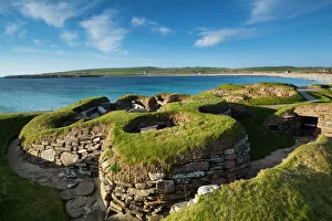
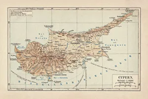
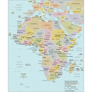
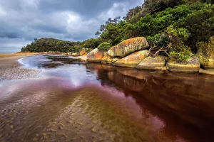
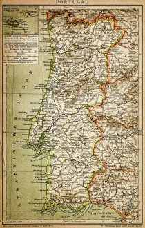
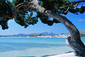
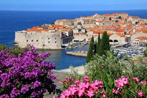
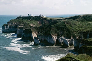
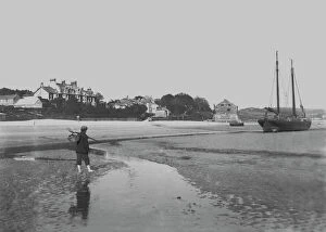
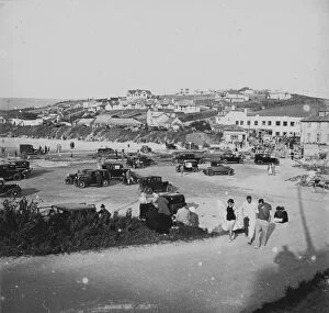
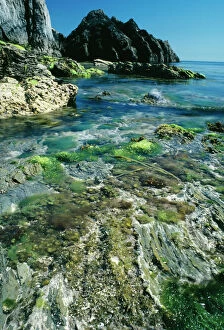
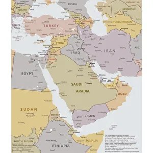
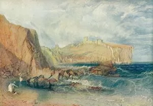
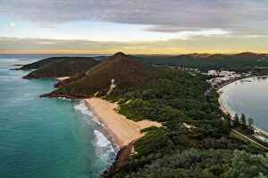
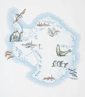
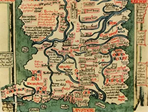
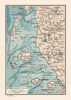
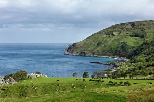
"Discovering the Beauty of Coastlines: From Cyprus to Scotland" Embark on a captivating journey along the coastlines captured in various historical maps and breathtaking photographs. Delve into the past with a Map of Cyprus, published in 1880, unveiling the island's intricate coastal features that have stood the test of time. Explore further as you navigate through a Political Map of Africa, tracing its diverse coastline that has witnessed centuries of trade and cultural exchange. Immerse yourself in history at Kingston Norfolk Island, where restored British penal colony buildings now grace this world heritage listed area. Picture No. 10741258 transports you to this enchanting spot, offering a glimpse into its rich maritime past. Continue your exploration with a Map of Portugal, revealing its stunning Atlantic coastline dotted with charming towns and pristine beaches. Journey southward to Wilsons Promontory in Victoria, Australia, where the Tidal River gracefully meets the rugged shoreline—an idyllic blend of land and sea. Venture northward to Scotland's Orkney Islands and discover Skara Brae Prehistoric Village nestled along its windswept coast—a testament to ancient civilizations living harmoniously by the sea. Ireland's Dingle Peninsula (AL 2367) captivates with its dramatic cliffs plunging into wild waters—nature's masterpiece captured by Ake Lindau. Transport yourself to Croatia as you marvel at an exquisite View of Old Town City Dubrovnik from its shimmering coastline—a fusion of medieval charm against azure waters. Flamborough Head in Yorkshire (UK JLM 10277) beckons nature enthusiasts with its towering cliffs overlooking crashing waves—an awe-inspiring sight etched forever in memory. Conclude your coastal odyssey at Swanage in Dorset, England—the picturesque town boasting panoramic views across tranquil shores—a haven for relaxation amidst natural beauty.