Fraud Blocker Skip to main content

County Map Of England Collection

Step back in time with these stunning old county maps of England

Background imageCounty Map Of England Collection: Old County Map of Hertfordshire 1611 by John Speed

Old County Map of Hertfordshire 1611 by John Speed
A facimile of John Speeds historical map of Hertfordshire originally published for the " Theatre of the Empire of Great Britain"

Background imageCounty Map Of England Collection: Old County Map of Suffolk 1611 by John Speed

Old County Map of Suffolk 1611 by John Speed
A facimile of John Speeds historical map of Norfolk originally published for the " Theatre of the Empire of Great Britain", an atlas to accompany " a history of Great Britain"

Background imageCounty Map Of England Collection: Old County Map of Cornwall 1611 by John Speed

Old County Map of Cornwall 1611 by John Speed
A facimile of John Speeds historical map of Cornwall originally published for the " Theatre of the Empire of Great Britain", an atlas to accompany " a history of Great Britain"

Background imageCounty Map Of England Collection: Old County Map of Bedfordshire 1611 by John Speed

Old County Map of Bedfordshire 1611 by John Speed
A fine reproduction of John Speeds historical map of Bedfordshire originally published for the " Theatre of the Empire of Great Britain"

Background imageCounty Map Of England Collection: Old County Map of Surrey 1648 by Johan Blaeu from the Atlas Novus

Old County Map of Surrey 1648 by Johan Blaeu from the Atlas Novus
This detailed and most attractive reproduction map of Surrey has been carefully art worked from a scan of an antique original

Background imageCounty Map Of England Collection: Old County Map of Shropshire 1836 by Thomas Moule

Old County Map of Shropshire 1836 by Thomas Moule
This is a fine decorative reproduction County Map of Shropshire from the First Edition series of Thomas Moule Maps, originally Published in 1836

Background imageCounty Map Of England Collection: Old County Map of Derbyshire 1611 by John Speed

Old County Map of Derbyshire 1611 by John Speed
A facimile of John Speeds historical map of Derbyshire originally published for the " Theatre of the Empire of Great Britain", an atlas to accompany " a history of Great Britain"

Background imageCounty Map Of England Collection: Old County Map of Lancashire 1611 by John Speed

Old County Map of Lancashire 1611 by John Speed
A facimile of John Speeds historical map of Lancashire published for the " Theatre of the Empire of Great Britain", an atlas to accompany " a history of Great Britain"

Background imageCounty Map Of England Collection: Old County Map of Yorkshire 1611 by John Speed

Old County Map of Yorkshire 1611 by John Speed
A facimile of John Speeds historical map of Yorkshire originally published for the " Theatre of the Empire of Great Britain", an atlas to accompany " a history of Great Britain"

Background imageCounty Map Of England Collection: Old County Map of Nottinghamshire 1611 by John Speed

Old County Map of Nottinghamshire 1611 by John Speed
A facimile of John Speeds historical map of Nottinghamshire originally published for the " Theatre of the Empire of Great Britain"

Background imageCounty Map Of England Collection: Old County Map of Worcestershire 1836 by Thomas Moule

Old County Map of Worcestershire 1836 by Thomas Moule
This is a fine decorative reproduction County Map of Worcestershire from the First Edition series of Thomas Moule Maps, originally Published in 1836

Background imageCounty Map Of England Collection: Old County Map of Somersetshire 1611 by John Speed

Old County Map of Somersetshire 1611 by John Speed
A facimile of John Speeds historical map of Somersetshire originally published for the " Theatre of the Empire of Great Britain"

Background imageCounty Map Of England Collection: Old County Map of Wiltshire 1836 by Thomas Moule

Old County Map of Wiltshire 1836 by Thomas Moule
This is a fine decorative reproduction County Map of Wiltshire from the First Edition series of Thomas Moule Maps, originally Published in 1836

Background imageCounty Map Of England Collection: Old County Map of Warwickshire 1648 by Johan Blaeu from the Atlas Novus

Old County Map of Warwickshire 1648 by Johan Blaeu from the Atlas Novus
This detailed and most attractive reproduction map of Warwickshire has been carefully art worked from a scan of an antique original

Background imageCounty Map Of England Collection: Old County Map of Suffolk 1836 by Thomas Moule

Old County Map of Suffolk 1836 by Thomas Moule
This is a fine decorative reproduction County Map of Suffolk from the First Edition series of Thomas Moule Maps, originally Published in 1836

Background imageCounty Map Of England Collection: Old County Map of Kent 1836 by Thomas Moule

Old County Map of Kent 1836 by Thomas Moule
This is a fine decorative reproduction County Map of Kent from the First Edition series of Thomas Moule Maps, originally Published in 1836

Background imageCounty Map Of England Collection: Old County Map of the East Riding of Yorkshire 1648 by Johan Blaeu from the Atlas Novus

Old County Map of the East Riding of Yorkshire 1648 by Johan Blaeu from the Atlas Novus
This detailed and most attractive reproduction map of the East Riding of Yorkshire has been carefully art worked from a scan of an antique original

Background imageCounty Map Of England Collection: Old County Map of Cumbria 1648 by Johan Blaeu from the Atlas Novus

Old County Map of Cumbria 1648 by Johan Blaeu from the Atlas Novus
This detailed and most attractive reproduction map of Cumbria has been carefully art worked from a scan of an antique original

Background imageCounty Map Of England Collection: Old County Map of Gloucestershire 1648 by Johan Blaeu from the Atlas Novus

Old County Map of Gloucestershire 1648 by Johan Blaeu from the Atlas Novus
This detailed and most attractive reproduction map of Gloucestershire has been carefully art worked from a scan of an antique original

Background imageCounty Map Of England Collection: Old County Map of Northamptonshire 1836 by Thomas Moule

Old County Map of Northamptonshire 1836 by Thomas Moule
This is a fine decorative reproduction County Map of Northamptonshire from the First Edition series of Thomas Moule Maps, originally Published in 1836

Background imageCounty Map Of England Collection: Old County Map of Yorkshire West Riding 1611 by John Speed

Old County Map of Yorkshire West Riding 1611 by John Speed
A facimile of John Speeds historical map of Yorkshire West Riding originally published for the " Theatre of the Empire of Great Britain"

Background imageCounty Map Of England Collection: Old County Map of Devonshire 1836 by Thomas Moule

Old County Map of Devonshire 1836 by Thomas Moule
This is a fine decorative reproduction County Map of Devonshire from the First Edition series of Thomas Moule Maps, originally Published in 1836

Background imageCounty Map Of England Collection: Old County Map of Warwickshire 1836 by Thomas Moule

Old County Map of Warwickshire 1836 by Thomas Moule
This is a fine decorative reproduction County Map of Warwickshire from the First Edition series of Thomas Moule Maps, originally Published in 1836

Background imageCounty Map Of England Collection: Old County Map of Sussex 1836 by Thomas Moule

Old County Map of Sussex 1836 by Thomas Moule
This is a fine decorative reproduction County Map of Sussex from the First Edition series of Thomas Moule Maps, originally Published in 1836

Background imageCounty Map Of England Collection: Old County Map of Cambridgeshire 1611 by John Speed

Old County Map of Cambridgeshire 1611 by John Speed
A facimile of John Speeds historical map of Cambridgeshire originally published for the " Theatre of the Empire of Great Britain"

Background imageCounty Map Of England Collection: Old County Map of Norfolk 1648 by Johan Blaeu from the Atlas Novus

Old County Map of Norfolk 1648 by Johan Blaeu from the Atlas Novus
This detailed and most attractive reproduction map of Norfolk has been carefully art worked from a scan of an antique original

Background imageCounty Map Of England Collection: Old County Map of Leicestershire 1611 by John Speed

Old County Map of Leicestershire 1611 by John Speed
A facimile of John Speeds historical map of Leicestershire originally published for the " Theatre of the Empire of Great Britain"

Background imageCounty Map Of England Collection: Old County Map of Northamptonshire 1611 by John Speed

Old County Map of Northamptonshire 1611 by John Speed
A facimile of John Speeds historical map of Northamptonshire originally published for the " Theatre of the Empire of Great Britain"

Background imageCounty Map Of England Collection: Old County Map of Bedfordshire 1836 by Thomas Moule

Old County Map of Bedfordshire 1836 by Thomas Moule
This is a fine decorative reproduction County Map of Bedfordshire from the First Edition series of Thomas Moule Maps, originally Published in 1836

Background imageCounty Map Of England Collection: OldCounty Map of Wiltshire 1611 by John Speed

OldCounty Map of Wiltshire 1611 by John Speed
A facimile of John Speeds historical map of Wiltshire published for the " Theatre of the Empire of Great Britain", an atlas to accompany " a history of Great Britain"

Background imageCounty Map Of England Collection: Old County Map of Kent 1611 by John Speed

Old County Map of Kent 1611 by John Speed
A facimile of John Speeds historical map of Kent originally published for the " Theatre of the Empire of Great Britain", an atlas to accompany " a history of Great Britain"

Background imageCounty Map Of England Collection: Old County Map of Lancashire 1836 by Thomas Moule

Old County Map of Lancashire 1836 by Thomas Moule
This is a fine decorative reproduction County Map of Lancashire from the First Edition series of Thomas Moule Maps, originally Published in 1836

Background imageCounty Map Of England Collection: Old County Map of Kent 1648 by Johan Blaeu from the Atlas Novus

Old County Map of Kent 1648 by Johan Blaeu from the Atlas Novus
This detailed and most attractive reproduction map of Kent has been carefully art worked from a scan of an antique original

Background imageCounty Map Of England Collection: Old County Map of Sussex 1648 by Johan Blaeu from the Atlas Novus

Old County Map of Sussex 1648 by Johan Blaeu from the Atlas Novus
This detailed and most attractive reproduction map of Sussex has been carefully art worked from a scan of an antique original

Background imageCounty Map Of England Collection: Old County Map of Buckinghamshire 1648 by Johan Blaeu from the Atlas Novus

Old County Map of Buckinghamshire 1648 by Johan Blaeu from the Atlas Novus
This detailed and most attractive reproduction map of Buckinghamshire has been carefully art worked from a scan of an antique original

Background imageCounty Map Of England Collection: Old County Map of Bedfordshire 1648 by Johan Blaeu from the Atlas Novus

Old County Map of Bedfordshire 1648 by Johan Blaeu from the Atlas Novus
This detailed and most attractive reproduction map of Bedfordshire has been carefully art worked from a scan of an antique original

Background imageCounty Map Of England Collection: Old County Map of Dorsetshire 1611 by John Speed

Old County Map of Dorsetshire 1611 by John Speed
A facimile of John Speeds historical map of Dorsetshire originally published for the " Theatre of the Empire of Great Britain", an atlas to accompany " a history of Great Britain"

Background imageCounty Map Of England Collection: Old County Map of Cambridgeshire 1648 by Johan Blaeu from the Atlas Novus

Old County Map of Cambridgeshire 1648 by Johan Blaeu from the Atlas Novus
This detailed and most attractive reproduction map of Cambridgeshire has been carefully art worked from a scan of an antique original

Background imageCounty Map Of England Collection: Old County Map of Cambridgeshire 1836 by Thomas Moule

Old County Map of Cambridgeshire 1836 by Thomas Moule
This is a fine decorative reproduction County Map of Cambridgeshire from the First Edition series of Thomas Moule Maps, originally Published in 1836

Background imageCounty Map Of England Collection: Old County Map of Gloucestershire 1836 by Thomas Moule

Old County Map of Gloucestershire 1836 by Thomas Moule
This is a fine decorative reproduction County Map of Gloucestershire from the First Edition series of Thomas Moule Maps, originally Published in 1836

Background imageCounty Map Of England Collection: Old County Map of Berkshire 1836 by Thomas Moule

Old County Map of Berkshire 1836 by Thomas Moule
This is a fine decorative reproduction County Map of Berkshire from the First Edition series of Thomas Moule Maps, originally Published in 1836

Background imageCounty Map Of England Collection: Old County Map of Cornwall 1836 by Thomas Moule

Old County Map of Cornwall 1836 by Thomas Moule
This is a fine decorative reproduction County Map of Cornwall from the First Edition series of Thomas Moule Maps, originally Published in 1836

Background imageCounty Map Of England Collection: Old County Map of Hampshire 1836 by Thomas Moule

Old County Map of Hampshire 1836 by Thomas Moule
This is a fine decorative reproduction County Map of Hampshire from the First Edition series of Thomas Moule Maps, originally Published in 1836

Background imageCounty Map Of England Collection: Old County Map of Derbyshire 1836 by Thomas Moule

Old County Map of Derbyshire 1836 by Thomas Moule
This is a fine decorative reproduction County Map of Derbyshire from the First Edition series of Thomas Moule Maps, originally Published in 1836

Background imageCounty Map Of England Collection: Old County Map of Cumberland 1836 by Thomas Moule

Old County Map of Cumberland 1836 by Thomas Moule
This is a fine decorative reproduction County Map of Cumberland from the First Edition series of Thomas Moule Maps, originally Published in 1836

Background imageCounty Map Of England Collection: Old County Map of Oxfordshire 1648 by Johan Blaeu from the Atlas Novus

Old County Map of Oxfordshire 1648 by Johan Blaeu from the Atlas Novus
This detailed and most attractive reproduction map of Oxfordshire has been carefully art worked from a scan of an antique original

Background imageCounty Map Of England Collection: Old County Map of Northumberland 1611 by John Speed

Old County Map of Northumberland 1611 by John Speed
A facimile of John Speeds historical map of Northumberland originally published for the " Theatre of the Empire of Great Britain"

Background imageCounty Map Of England Collection: Old County Map of Somersetshire 1836 by Thomas Moule

Old County Map of Somersetshire 1836 by Thomas Moule
This is a fine decorative reproduction County Map of Somersetshire from the First Edition series of Thomas Moule Maps, originally Published in 1836


All Professionally Made to Order for Quick Shipping

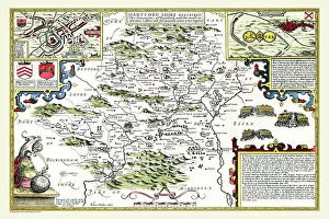
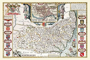
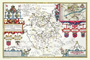
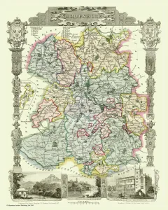
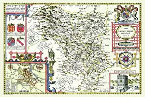
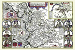
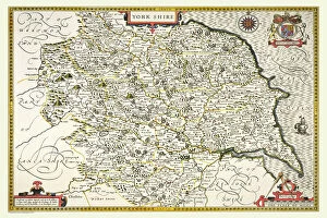
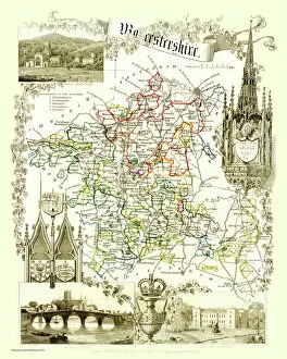
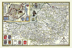
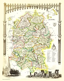
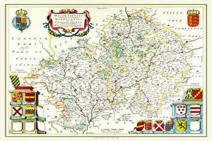
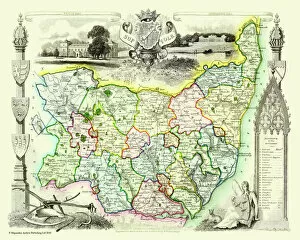
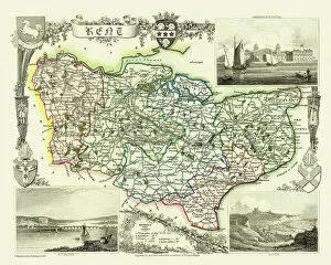
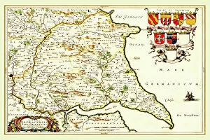
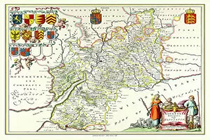
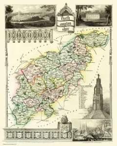
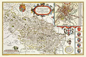
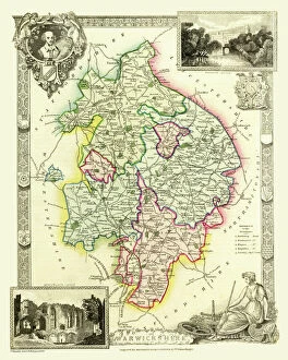
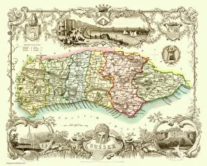
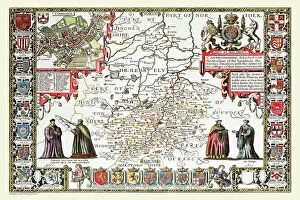
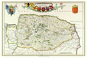
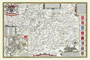
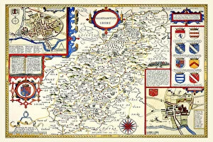
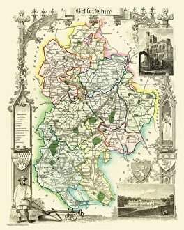
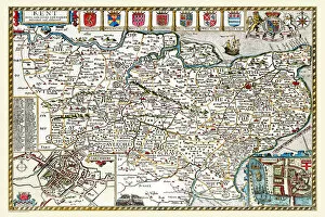
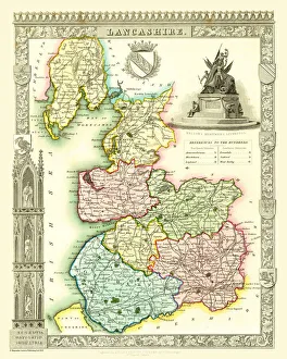
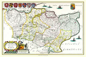
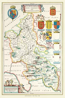
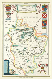
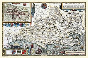
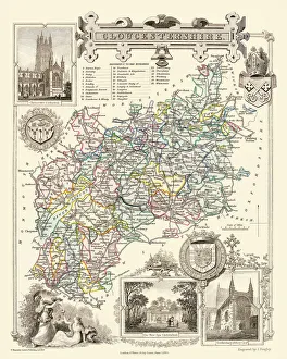
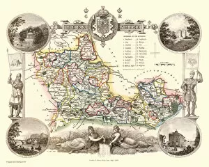
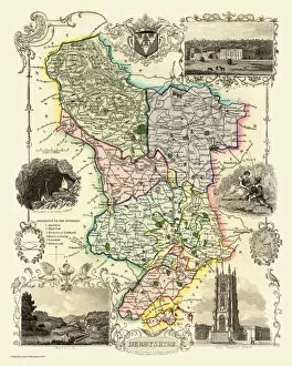
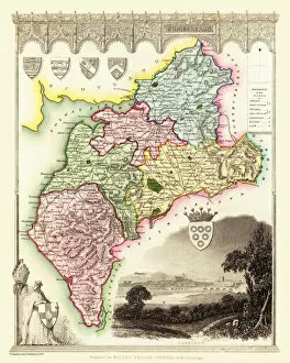
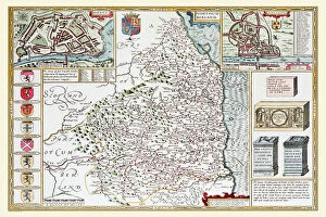
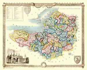
Step back in time with these stunning old county maps of England. From the intricate details to the historical significance, each map tells a unique story about its respective region. First up is the Old County Map of Hertfordshire 1611 by John Speed. This beautifully crafted map showcases the county's boundaries and towns during that era, providing a glimpse into its past. Moving on to Worcestershire, we have the Old County Map of Worcestershire 1836 by Thomas Moule. This map captures the essence of this picturesque county, highlighting its charming villages and rolling countryside. Next, let's explore Cornwall through the eyes of John Speed with his Old County Map of Cornwall 1611. Discover ancient landmarks and coastal beauty as you navigate through this historic gem. Shropshire comes alive in the Old County Map of Shropshire 1836 by Thomas Moule. Uncover hidden treasures within this enchanting county as you trace your finger along its winding rivers and lush landscapes. Lancashire takes center stage with John Speed's Old County Map of Lancashire 1611. Immerse yourself in Lancashire's rich heritage as you traverse through bustling market towns and idyllic rural scenes. Yorkshire steals our attention with not one but two captivating maps - Yorkshire West Riding 1611 by John Speed and Yorkshire East Riding 1648 by Johan Blaeu from Atlas Novus. These maps offer an insight into Yorkshire's vastness, showcasing its diverse terrain from rugged moorlands to thriving cities. Nottinghamshire reveals itself in all its glory with John Speed's Old County Map of Nottinghamshire 1611. Explore Sherwood Forest or follow Robin Hood’s footsteps across this legendary land steeped in folklore. Derbyshire unveils its secrets through John Speed’s detailed depiction on his Old County Map of Derbyshire 1611. Marvel at Peak District National Park or discover quaint villages nestled within this captivating county.