
Demarcation Collection
"Demarcation: Tracing the Lines of History" In the tumultuous year of 1939, Germany and Russia engaged in secret negotiations to discuss the division of Poland


All Professionally Made to Order for Quick Shipping
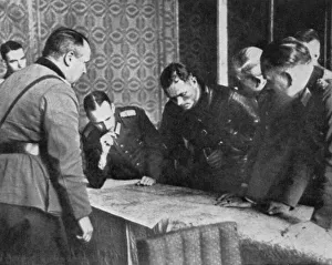
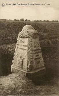
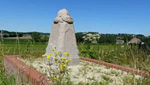
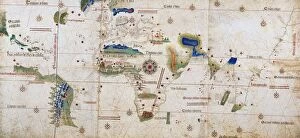
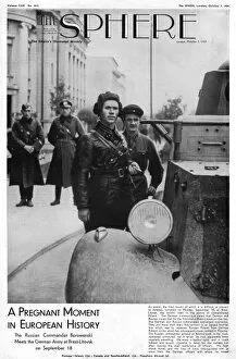
"Demarcation: Tracing the Lines of History" In the tumultuous year of 1939, Germany and Russia engaged in secret negotiations to discuss the division of Poland. The demarcation lines drawn during these discussions would forever alter the course of history. Amidst the chaos of World War I, Ypres became synonymous with devastation. At Hell Fire Corner, a British Demarcation Stone stood as a grim reminder of the fierce battles that took place there. Further south in Locre South (Kemmel), another Demarcation Stone marked a poignant spot where lives were lost and territories shifted hands. It served as a silent witness to the ever-changing borders on European soil. In Italy, amidst treacherous minefields by the River Senio, white tape meticulously marked clear tracks for soldiers to navigate through danger. This simple demarcation ensured their safe passage through an otherwise deadly landscape. A notable figure in military history was Major-General Sir Peters Lumsden, whose achievements were immortalized in engravings. His strategic prowess played a crucial role in defining boundaries and establishing order amidst chaos. The complex issue of Palestine-Israel relations came into focus in 1953 when relief maps depicting Jerusalem's demarcations emerged. These maps aimed to shed light on territorial disputes and provide clarity amid ongoing tensions. Centuries earlier, cartographers like Alberto Cantino shaped our understanding of geography with their world maps. In his 1502 masterpiece, Africa took center stage - its contours carefully delineated for all to see. Delving deeper into history reveals figures like Arnaldus de Villa Nova who left indelible marks on scientific thought. His works explored various aspects including demarcating medical knowledge and pushing boundaries within academia itself. As war loomed over Europe once again in 1939, Borowenski's sphere cover at Brest-Litovsk symbolized both protection and division.