Fraud Blocker Skip to main content

Inaccurate Collection

"Inaccurate: Unveiling the Historical Missteps in Maps and Artifacts" Albrecht Durer's Rhinoceros

Background imageInaccurate Collection: Albrecht Durers Rhinoceros

Albrecht Durers Rhinoceros
An Indian rhinoceros, is the largest of the Asian species, as depicted by Albrecht Durer. It has a thick, dark grey hide, which folds like armour

Background imageInaccurate Collection: 17th century world map

17th century world map
World map, published around 1664 in Amsterdam, the Netherlands, by Dutch mapmaker Joan Blaeu (c.1599- 1673). The Latin title is Nova et Accuratissima Totius Terrarum Orbis Tabula

Background imageInaccurate Collection: 16th century map of the British Isles

16th century map of the British Isles
Map of the British Isles, in the 1570 edition of Ortelius Atlas (Theatrum Orbis Terrarum). Abraham Ortelius (1527-1598) was a Flemish mapmaker who is considered to have produced the first true atlas

Background imageInaccurate Collection: 16th century world map

16th century world map
World map, published around 1565 in Venice, Italy, by Italian mapmaker Ferando Bertelli. The title of the map: Universale Descrittione di Tutta la Terra Conosciuta Fin Qui

Background imageInaccurate Collection: 17th century map of Europe

17th century map of Europe

Background imageInaccurate Collection: 17th century map of the New World

17th century map of the New World
Western Hemisphere, 17th century Dutch map. This shows the New World that was being discovered by Europeans exploring the Western Hemisphere of the Earth

Background imageInaccurate Collection: 16th century map of the British Isles

16th century map of the British Isles
British Isles, 16th century Dutch map. This shows England, Scotland, Wales and Ireland, though Ireland is not yet accurately mapped. Published in 1595, from work by Gerard Mercator

Background imageInaccurate Collection: Europe, 16th century nautical map

Europe, 16th century nautical map
Nautical map of Europe, 1544 copy of Agnese Atlas. Several copies of this atlas were produced between 1536 and 1564, in Venice, by the Italian mapmaker Battista Agnese

Background imageInaccurate Collection: 17th century map of the New World

17th century map of the New World

Background imageInaccurate Collection: 17th century map of South America

17th century map of South America
South America, 17th century Dutch map. This shows the new continent that was being discovered by European explorers. The shape is distorted because it had not yet been accurately mapped

Background imageInaccurate Collection: Loggerhead sea turtle, Caretta caretta (loggerhead turtle, Testudo caretta). Endangered

Loggerhead sea turtle, Caretta caretta (loggerhead turtle, Testudo caretta). Endangered
FLO4694537 Loggerhead sea turtle, Caretta caretta (loggerhead turtle, Testudo caretta). Endangered. Inaccurate drawing by Aldrovandus

Background imageInaccurate Collection: RMS Titanic - letter, Mabel Francatelli, passenger

RMS Titanic - letter, Mabel Francatelli, passenger
RMS Titanic - First Class passenger Mabel Francatelli. A fascinating letter from Mattison, Davey & Rader of New York to Miss Francatelli dated 17 April 1956

Background imageInaccurate Collection: An artistic representation - Discovery of Tutankhamun's Tomb

An artistic representation - Discovery of Tutankhamun's Tomb
An artistic representation of the Discovery of the Tomb of Tutankhamun by (on right) Archeologist Howard Carter (1874-1939) and his backer (on left) George Herbert, 5th Earl of Carnarvon (1866-1923)

Background imageInaccurate Collection: Why is a flat map inaccurate? (litho)

Why is a flat map inaccurate? (litho)
3642518 Why is a flat map inaccurate? (litho) by English School, (20th century); Private Collection; (add.info.: Why is a flat map inaccurate)

Background imageInaccurate Collection: Schleicher ASW17 26

Schleicher ASW17 26, on the grid at a gliding competition in the UK. This aircraft, owned by the Royal Air Force Gliding and Soaring Association (RAFGSA)

Background imageInaccurate Collection: Map of the Cittie of London, 1633 (hand-coloured engraving)

Map of the Cittie of London, 1633 (hand-coloured engraving)
495412 Map of the Cittie of London, 1633 (hand-coloured engraving) by Ryther, Augustus (fl.1572-92) (atrr. to); Private Collection; (add.info.: This plan was produced to satisfy a European market)

Background imageInaccurate Collection: antique, archival, bay of bengal, border, cartography, country, document, geography

antique, archival, bay of bengal, border, cartography, country, document, geography, historic, historical, inaccurate, india, indian ocean, malaysia, map, nobody, peninsula, scale, text, thailand

Background imageInaccurate Collection: Magellans route, 16th century map

Magellans route, 16th century map
Magellans route around the world, in a 1544 copy of the Agnese Atlas. Magellans route is shown as a dark line. Ferdinand Magellan (c.1480-1521) set sail from Seville, Spain

Background imageInaccurate Collection: Map of Great Britain, France and Spain, 1473 (engraving)

Map of Great Britain, France and Spain, 1473 (engraving)
XJF134226 Map of Great Britain, France and Spain, 1473 (engraving) by Benincasa, Grazioso (fl.1468); Private Collection; Italian, out of copyright

Background imageInaccurate Collection: Death triumphant. From Hartmann Schedel Liber chronicarum mundi (Nuremberg Chronicle), 1493

Death triumphant. From Hartmann Schedel Liber chronicarum mundi (Nuremberg Chronicle), 1493. Skeletons anatomically inaccurate, especially bones of the pelvis. Woodcut

Background imageInaccurate Collection: Gilbert Stuart (1742-1786) Scottish historical essayist, born in Edinburgh. Jealous and irrascible

Gilbert Stuart (1742-1786) Scottish historical essayist, born in Edinburgh. Jealous and irrascible, he attacked the work of other contemporary historical authors

Background imageInaccurate Collection: Passing on news, conceptual artwork

Passing on news, conceptual artwork
Passing on news. Conceptual artwork of a series of successively larger human mouths calling out. This can represent media communication where news can come from multiple sources passing on the same

Background imageInaccurate Collection: Russian whaling, 1760

Russian whaling, 1760
18th century Russian whaling. Woodcut engraving showing the hunting and catching of a whale in 1760, in the White Sea off Arkhangelsk (Archangel), Russia

Background imageInaccurate Collection: Iguanodon and Megalosaurus dinosaurs

Iguanodon and Megalosaurus dinosaurs
Iguanodon (left) and Megalosaurus (right), historical artwork. This inaccurate reconstruction shows the dinosaurs co-existing when they actually date from two different time periods

Background imageInaccurate Collection: 17th century map of Japan

17th century map of Japan
Japan, 17th century Dutch map. These lands had not yet been accurately mapped by Europeans, and the islands of Japan (centre to centre right) are much distorted

Background imageInaccurate Collection: Halleys Comet in May 1910

Halleys Comet in May 1910. The April 1910 approach of Halleys Comet was the first for which photographs exist. The approach was relatively close

Background imageInaccurate Collection: Artwork of twelve catarrhines, 1870

Artwork of twelve catarrhines, 1870
Twelve catarrhines. Historical artwork of twelve apes and Old World monkeys, from the 1870 edition of Ernst Haeckels The Natural History of Creation. These drawings are not entirely accurate

Background imageInaccurate Collection: Speedometer testing

Speedometer testing
Gongsters on parade; police cars of the police traffic patrol waiting to have their speedometers tested against a stopwatch, to ensure they drive within the 30 miles and hour speed limit

Background imageInaccurate Collection: Chinese Rocket Launcher

Chinese Rocket Launcher
Chinese rocket launcher: inaccurate but ingenious


All Professionally Made to Order for Quick Shipping

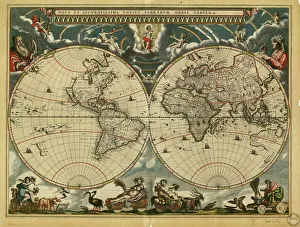
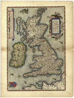
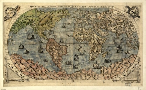
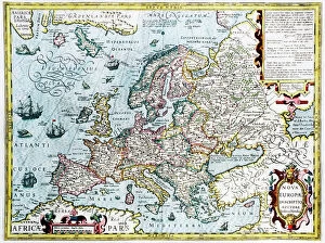
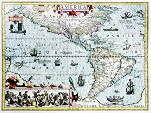
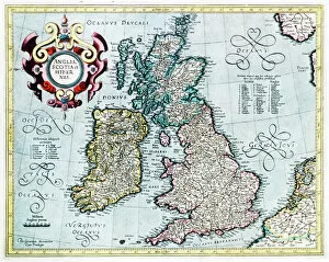
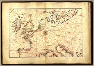
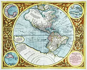
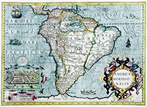
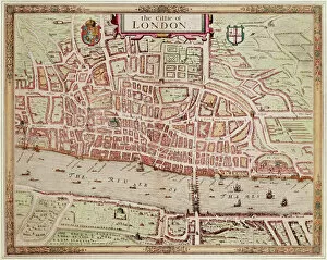
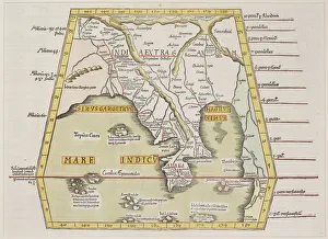
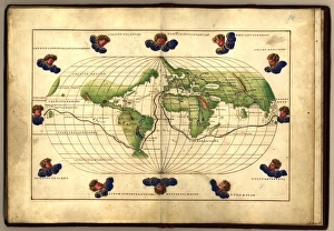
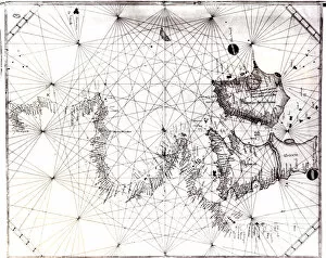
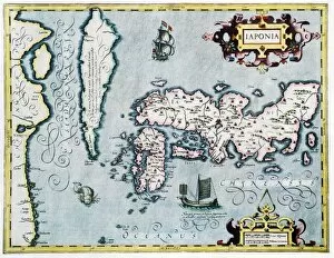
"Inaccurate: Unveiling the Historical Missteps in Maps and Artifacts" Albrecht Durer's Rhinoceros: A stunning artwork from the 16th century that beautifully captures the imagination, but unfortunately depicts a rhino with some inaccuracies. Navigating Through Time: Exploring the intricacies of 17th-century world maps, where cartographers struggled to accurately represent distant lands due to limited knowledge and technology. Mysterious British Isles: Delving into a captivating 16th-century map of the British Isles, revealing how early cartographers grappled with incomplete information resulting in misleading representations. Europe's Shifting Borders: Examining a fascinating 17th-century map of Europe that showcases territorial claims and political divisions, yet fails to capture evolving boundaries accurately. The New World's Elusive Geography: Unraveling the complexities of a 17th-century map depicting uncharted territories in America, highlighting explorers' struggles to navigate unknown lands precisely. Sailing through Uncertainty: Analyzing an intriguing nautical map from 16th-century Europe, which showcases maritime routes but also reveals navigational challenges faced by sailors at sea. Challenging Cartographic Conundrums: Rediscovering another flawed representation of the British Isles on a centuries-old map, shedding light on historical mapping errors that puzzled scholars for years. South America's Enigmatic Landscape: Decoding a mesmerizing 17th-century map showcasing South America's diverse geography while acknowledging its inaccuracies caused by limited exploration data available at that time. Halley's Comet Spectacle (1910): Reflecting on an astronomical event witnessed worldwide in May 1910 when Halley's Comet returned after centuries; however, scientific predictions fell short due to inaccurate calculations causing disappointment among stargazers. Titanic Tales Unearthed.