Fraud Blocker Skip to main content

John Tallis Map Collection (page 2)

Step back in time with the John Tallis map collection, a treasure trove of historical cartography

Background imageJohn Tallis Map Collection: Old Map of West Canada 1851 by John Tallis

Old Map of West Canada 1851 by John Tallis
A fine facimile artworked from an antique original map of West Canada, issued as part of the 1851 edition of John Tallis and Companys " The Illustrated Atlas and Modern History of the World"

Background imageJohn Tallis Map Collection: Old Map of Preston 1851 by John Tallis

Old Map of Preston 1851 by John Tallis
The River Ribble in Lancashire by John Tallis 1851 with a most rural presentation of Preston surrounded by numerous meadows and open fields. The plan is beautifully finished with seven illustrations

Background imageJohn Tallis Map Collection: Russia in Europe 1851

Russia in Europe 1851
A fine facimile artworked from an antique original map of Russia in Europe, issued as part of the 1851 edition of John Tallis and Companys " The Illustrated Atlas

Background imageJohn Tallis Map Collection: Sweden & Norway 1851

Sweden & Norway 1851
A fine facimile artworked from an antique original map of Sweden and Norway, issued as part of the 1851 edition of John Tallis and Companys " The Illustrated Atlas

Background imageJohn Tallis Map Collection: Western Africa 1851

Western Africa 1851
A fine facimile artworked from an antique original map of Western Africa, issued as part of the 1851 edition of John Tallis and Companys " The Illustrated Atlas

Background imageJohn Tallis Map Collection: Japan & Korea 1851

Japan & Korea 1851
A fine facimile artworked from an antique original map of Japan and Korea, issued as part of the 1851 edition of John Tallis and Companys " The Illustrated Atlas

Background imageJohn Tallis Map Collection: New South Wales 1851

New South Wales 1851
A fine facimile artworked from an antique original map of New South Wales, Australia, issued as part of the 1851 edition of John Tallis and Companys " The Illustrated Atlas

Background imageJohn Tallis Map Collection: British Isles 1851

British Isles 1851
A fine facimile artworked from an antique original map of The British Isles, issued as part of the 1851 edition of John Tallis and Companys " The Illustrated Atlas

Background imageJohn Tallis Map Collection: Polynesia, or Islands in the Pacific Ocean 1851

Polynesia, or Islands in the Pacific Ocean 1851
A fine facimile artworked from an antique original map of Polynesia, or Islands in the Pacific Ocean, issued as part of the 1851 edition of John Tallis and Companys " The Illustrated Atlas

Background imageJohn Tallis Map Collection: Old Map of Nova Scotia and Newfoundland 1851 by John Tallis

Old Map of Nova Scotia and Newfoundland 1851 by John Tallis
A fine facimile artworked from an antique original map of Nova Scotia and Newfoundland, issued as part of the 1851 edition of John Tallis and Companys " The Illustrated Atlas

Background imageJohn Tallis Map Collection: Overland Route to India 1851

Overland Route to India 1851
A fine facimile artworked from an antique original map of the Overland Route to India, issued as part of the 1851 edition of John Tallis and Companys " The Illustrated Atlas

Background imageJohn Tallis Map Collection: Old Map of Northern Africa 1851 by John Tallis

Old Map of Northern Africa 1851 by John Tallis
A fine facimile artworked from an antique original map of Northern Africa, issued as part of the 1851 edition of John Tallis and Companys " The Illustrated Atlas

Background imageJohn Tallis Map Collection: Old Map of Mexico, California & Texas 1851by John Tallis

Old Map of Mexico, California & Texas 1851by John Tallis
A fine facimile artworked from an antique original map of Mexico, California and Texas, issued as part of the 1851 edition of John Tallis and Companys " The Illustrated Atlas

Background imageJohn Tallis Map Collection: Old Map of North America 1851 by John Tallis

Old Map of North America 1851 by John Tallis
A fine reproduction artworked from an antique original map of North America, issued as part of the 1851 edition of John Tallis and Companys " The Illustrated Atlas

Background imageJohn Tallis Map Collection: Old Map of Brazil 1851 by John Tallis

Old Map of Brazil 1851 by John Tallis
A fine facimile artworked from an antique original map of Brazil, issued as part of the 1851 edition of John Tallis and Companys " The Illustrated Atlas and Modern History of the World"

Background imageJohn Tallis Map Collection: Asia Minor 1851

Asia Minor 1851
A fine facimile artworked from an antique original map of Asia Minor, issued as part of the 1851 edition of John Tallis and Companys " The Illustrated Atlas and Modern History of the World"

Background imageJohn Tallis Map Collection: Ireland 1851

Ireland 1851
A fine facimile artworked from an antique original map of Ireland, issued as part of the 1851 edition of John Tallis and Companys " The Illustrated Atlas and Modern History of the World"

Background imageJohn Tallis Map Collection: Old Map of British America, or Canada 1851 by John Tallis

Old Map of British America, or Canada 1851 by John Tallis
A fine facimile artworked from an antique original map of British America or Canada, issued as part of the 1851 edition of John Tallis and Companys " The Illustrated Atlas

Background imageJohn Tallis Map Collection: Northern India 1851

Northern India 1851
A fine facimile artworked from an antique original map of Northern India, issued as part of the 1851 edition of John Tallis and Companys " The Illustrated Atlas

Background imageJohn Tallis Map Collection: Old Map of the United States of America 1851 by John Tallis

Old Map of the United States of America 1851 by John Tallis
A fine facimile artworked from an antique original map of the United States of America, issued as part of the 1851 edition of John Tallis and Companys " The Illustrated Atlas

Background imageJohn Tallis Map Collection: Old Map of Africa 1851 by John Tallis

Old Map of Africa 1851 by John Tallis
A fine facimile artworked from an antique original map of the Continent of Africa, issued as part of the 1851 edition of John Tallis and Companys " The Illustrated Atlas

Background imageJohn Tallis Map Collection: Old Map of Central America 1851 by John Tallis

Old Map of Central America 1851 by John Tallis
A fine facimile artworked from an antique original map of Central America, issued as part of the 1851 edition of John Tallis and Companys " The Illustrated Atlas

Background imageJohn Tallis Map Collection: Gibraltar, Malta, and Ionian Isles 1851

Gibraltar, Malta, and Ionian Isles 1851
A fine facimile artworked from an antique original map of Gibraltar, Malta and Ionian Isles, issued as part of the 1851 edition of John Tallis and Companys " The Illustrated Atlas

Background imageJohn Tallis Map Collection: Syria 1851

Syria 1851
A fine facimile artworked from an antique original map of Syria, issued as part of the 1851 edition of John Tallis and Companys " The Illustrated Atlas and Modern History of the World"

Background imageJohn Tallis Map Collection: Switzerland 1851

Switzerland 1851
A fine facimile artworked from an antique original map of Switzerland, issued as part of the 1851 edition of John Tallis and Companys " The Illustrated Atlas and Modern History of the World"

Background imageJohn Tallis Map Collection: Part of South Australia 1851

Part of South Australia 1851
A fine facimile artworked from an antique original map of Part of South Australia, issued as part of the 1851 edition of John Tallis and Companys " The Illustrated Atlas

Background imageJohn Tallis Map Collection: Old Map of Venezuela, New Granada, Equador and The Guayanas 1851 by John Tallis

Old Map of Venezuela, New Granada, Equador and The Guayanas 1851 by John Tallis
A fine facimile artworked from an antique original map of Venezuela, New Granada, Equador and The Guayanas, issued as part of the 1851 edition of John Tallis

Background imageJohn Tallis Map Collection: Northern Italy 1851

Northern Italy 1851
A fine facimile artworked from an antique original map of Northern Italy, issued as part of the 1851 edition of John Tallis and Companys " The Illustrated Atlas

Background imageJohn Tallis Map Collection: Denmark 1851

Denmark 1851
A fine facimile artworked from an antique original map of Denmark, issued as part of the 1851 edition of John Tallis and Companys " The Illustrated Atlas and Modern History of the World"

Background imageJohn Tallis Map Collection: China & Burma 1851

China & Burma 1851
A fine facimile artworked from an antique original map of China and Burma, issued as part of the 1851 edition of John Tallis and Companys " The Illustrated Atlas

Background imageJohn Tallis Map Collection: Eastern Hemisphere 1851

Eastern Hemisphere 1851
A fine facimile artworked from an antique original map of The Eastern Hemisphere, issued as part of the 1851 edition of John Tallis and Companys " The Illustrated Atlas

Background imageJohn Tallis Map Collection: Russia in Asia 1851

Russia in Asia 1851
A fine facimile artworked from an antique original map of Russia in Europe, issued as part of the 1851 edition of John Tallis and Companys " The Illustrated Atlas

Background imageJohn Tallis Map Collection: Greece 1851

Greece 1851
A fine facimile artworked from an antique original map of Greece, issued as part of the 1851 edition of John Tallis and Companys " The Illustrated Atlas and Modern History of the World"

Background imageJohn Tallis Map Collection: Islands in the Indian Ocean 1851

Islands in the Indian Ocean 1851
A fine facimile artworked from an antique original map of the Islands in the Indian Ocean, issued as part of the 1851 edition of John Tallis and Companys " The Illustrated Atlas

Background imageJohn Tallis Map Collection: England & Wales 1851

England & Wales 1851
A fine facimile artworked from an antique original map of England and Wales, issued as part of the 1851 edition of John Tallis and Companys " The Illustrated Atlas

Background imageJohn Tallis Map Collection: Western Hemisphere 1851

Western Hemisphere 1851
A fine facimile artworked from an antique original map of The Western Hemisphere, issued as part of the 1851 edition of John Tallis and Companys " The Illustrated Atlas

Background imageJohn Tallis Map Collection: Turkey in Asia 1851

Turkey in Asia 1851
A fine facimile artworked from an antique original map of Turkey in Asia, issued as part of the 1851 edition of John Tallis and Companys " The Illustrated Atlas

Background imageJohn Tallis Map Collection: Asia 1851

Asia 1851
A fine facimile artworked from an antique original map of the Continent of Asia, issued as part of the 1851 edition of John Tallis and Companys " The Illustrated Atlas

Background imageJohn Tallis Map Collection: Germany 1851

Germany 1851
A fine facimile artworked from an antique original map of Germany, issued as part of the 1851 edition of John Tallis and Companys " The Illustrated Atlas and Modern History of the World"

Background imageJohn Tallis Map Collection: Independent Tartary 1851

Independent Tartary 1851
A fine facimile artworked from an antique original map of the Independant Tartary, issued as part of the 1851 edition of John Tallis and Companys " The Illustrated Atlas


All Professionally Made to Order for Quick Shipping

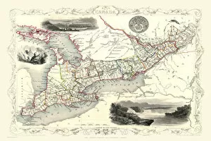
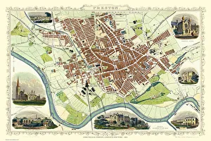
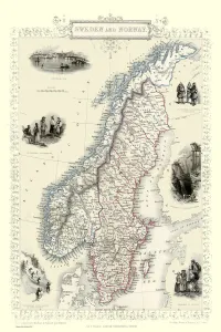
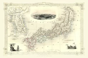
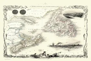
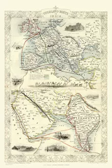
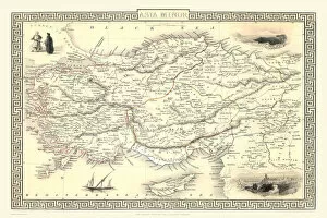
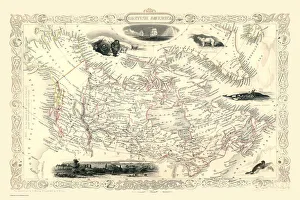
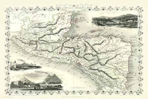
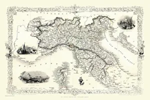
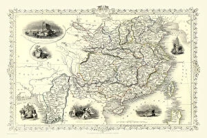
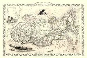
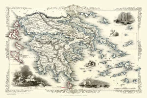
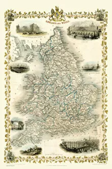
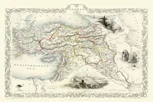
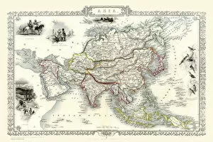
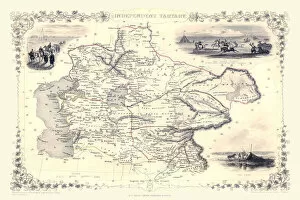
Step back in time with the John Tallis map collection, a treasure trove of historical cartography. These beautifully detailed maps offer a glimpse into the past, showcasing cities and regions as they were in 1851. From the charming seaside town of Brighton to the bustling streets of Birmingham, each map is a window into a bygone era. Explore the winding lanes and elegant architecture of Bath through Tallis' intricate illustrations. Marvel at the industrial might of Sheffield or discover Aberdeen's rich maritime heritage. Journey across Van Diemens Island (now known as Tasmania) and witness Australia's early development during this pivotal year. Delve into Belfast's fascinating history or trace Bradford's rise as an industrial powerhouse. Lose yourself in Perth Scotland's enchanting landscapes or navigate Leeds' vibrant cityscape through these captivating maps. With their meticulous attention to detail, these John Tallis maps provide not only geographical information but also cultural insights from over 150 years ago. Whether you're an avid historian or simply curious about how your favorite places have evolved, these vintage maps are sure to captivate your imagination. So take a step back in time and immerse yourself in the world of John Tallis. Let his exquisite cartography transport you to another era where horse-drawn carriages roamed cobbled streets and grand buildings stood tall. Discover forgotten corners of cities long gone or marvel at familiar landmarks that have stood the test of time. The John Tallis map collection is more than just ink on paper; it is a gateway to our shared past, inviting us to explore and appreciate the beauty and complexity of our world throughout history.