Fraud Blocker Skip to main content

Old Scottish County Map Collection

Step back in time with these stunning old Scottish county maps

Background imageOld Scottish County Map Collection: Old County Map of Stirling and Clackmannan Scotland 1847 by A&C Black

Old County Map of Stirling and Clackmannan Scotland 1847 by A&C Black
A finely detailed facimile remastered in full colour from an antique original map of Stirling and Clackmannan featured in A&C Blacks Atlas of 1847

Background imageOld Scottish County Map Collection: Old County Map of Wigtown Scotland 1847 by A&C Black

Old County Map of Wigtown Scotland 1847 by A&C Black
A finely detailed facimile remastered in full colour from an antique original map of Wigtownshire featured in A&C Blacks Atlas of 1847

Background imageOld Scottish County Map Collection: Old County Map of Fife 1654 by Johan Blaeu from the Atlas Novus

Old County Map of Fife 1654 by Johan Blaeu from the Atlas Novus
This detailed and most attractive reproduction map of Fife has been carefully art worked from a scan of an antique original

Background imageOld Scottish County Map Collection: Old County Map of Kyle and Mid Ayrshire 1654 by johan Blaeu from the Atlas Novus

Old County Map of Kyle and Mid Ayrshire 1654 by johan Blaeu from the Atlas Novus
This detailed and most attractive reproduction map of Kyle and Mid Ayrshire has been carefully art worked from a scan of an antique original

Background imageOld Scottish County Map Collection: Old County Map of Dunbartonshire, formally called Dumbartonshire, Scotland 1847 by A&C Black

Old County Map of Dunbartonshire, formally called Dumbartonshire, Scotland 1847 by A&C Black
A finely detailed facimile remastered in full colour from an antique original map of " Dumbartonshire" featured in A&C Blacks Atlas of 1847

Background imageOld Scottish County Map Collection: Old Map of the County of Sutherland from the Philips Handy Atlas of 1882

Old Map of the County of Sutherland from the Philips Handy Atlas of 1882
PHA030

Background imageOld Scottish County Map Collection: Old County Map of Ayr Scotland 1847 by A&C Black

Old County Map of Ayr Scotland 1847 by A&C Black
A finely detailed facimile remastered in full colour from an antique original map of Ayr featured in A&C Blacks Atlas of 1847

Background imageOld Scottish County Map Collection: Old County Map of Sutherland Scotland 1847 by A&C Black

Old County Map of Sutherland Scotland 1847 by A&C Black
A finely detailed facimile remastered in full colour from an antique original map of Sutherland featured in A&C Blacks Atlas of 1847

Background imageOld Scottish County Map Collection: Old County Map of Caithness Scotland 1847 by A&C Black

Old County Map of Caithness Scotland 1847 by A&C Black
A finely detailed facimile remastered in full colour from an antique original map of Caithness featured in A&C Blacks Atlas of 1847

Background imageOld Scottish County Map Collection: Old County Map of Moray and Nairn Scotland 1847 by A&C Black

Old County Map of Moray and Nairn Scotland 1847 by A&C Black
A finely detailed facimile remastered in full colour from an antique original map of Moray and Nairn featured in A&C Blacks Atlas of 1847

Background imageOld Scottish County Map Collection: Old Map of the Counties of Ross and Cromarty from the Philips Handy Atlas of 1882

Old Map of the Counties of Ross and Cromarty from the Philips Handy Atlas of 1882
PHA026

Background imageOld Scottish County Map Collection: Old Map of the Counties of Stirling and Clackmannan from the Philips Handy Atlas of 1882

Old Map of the Counties of Stirling and Clackmannan from the Philips Handy Atlas of 1882
PHA029

Background imageOld Scottish County Map Collection: Old County Map of Renfrewshire Scotland 1654 by Johan Blaue from the Atlas Novus

Old County Map of Renfrewshire Scotland 1654 by Johan Blaue from the Atlas Novus
This detailed and most attractive reproduction map of Renfrewshire, Scotland, has been carefully art worked from a scan of an antique original

Background imageOld Scottish County Map Collection: Old County Map of Aberdeen and Banff Scotland 1847 by A&C Black

Old County Map of Aberdeen and Banff Scotland 1847 by A&C Black
A finely detailed facimile remastered in full colour from an antique original map of Aberdeen and Banff featured in A&C Blacks Atlas of 1847

Background imageOld Scottish County Map Collection: Old Map of the Counties of Fife and Kinross from the Philips Handy Atlas of 1882

Old Map of the Counties of Fife and Kinross from the Philips Handy Atlas of 1882
PHA014

Background imageOld Scottish County Map Collection: Old County Map of Renfrew Scotland 1847 by A&C Black

Old County Map of Renfrew Scotland 1847 by A&C Black
A finely detailed facimile remastered in full colour from an antique original map of Renfrewshire featured in A&C Blacks Atlas of 1847

Background imageOld Scottish County Map Collection: Old Map of the County of Kirkcudbright from the Philips Handy Atlas of 1882

Old Map of the County of Kirkcudbright from the Philips Handy Atlas of 1882
PHA019

Background imageOld Scottish County Map Collection: Old Map of the County of Haddington from the Philips Handy Atlas of 1882

Old Map of the County of Haddington from the Philips Handy Atlas of 1882
PHA016

Background imageOld Scottish County Map Collection: Old Map of the County of Inverness from the Philips Handy Atlas of 1882

Old Map of the County of Inverness from the Philips Handy Atlas of 1882
PHA017

Background imageOld Scottish County Map Collection: Old Map of the County of Linlithgow from the Philips Handy Atlas of 1882

Old Map of the County of Linlithgow from the Philips Handy Atlas of 1882
PHA021

Background imageOld Scottish County Map Collection: Old Map of the County of Berwick from the Philips Handy Atlas of 1882

Old Map of the County of Berwick from the Philips Handy Atlas of 1882
PHA006

Background imageOld Scottish County Map Collection: Old County Map of Dumfries Scotland 1847 by A&C Black

Old County Map of Dumfries Scotland 1847 by A&C Black
A finely detailed facimile remastered in full colour from an antique original map of Dumfries featured in A&C Blacks Atlas of 1847

Background imageOld Scottish County Map Collection: Old County Map of Kurkcudbright Scotland 1847 by A&C Black

Old County Map of Kurkcudbright Scotland 1847 by A&C Black
A finely detailed facimile remastered in full colour from an antique original map of Kurkcudbright featured in A&C Blacks Atlas of 1847

Background imageOld Scottish County Map Collection: Old County Map of Ross and Cromarty Scotland 1847 by A&C Black

Old County Map of Ross and Cromarty Scotland 1847 by A&C Black
A finely detailed facimile remastered in full colour from an antique original map of Ross and Cromarty featured in A&C Blacks Atlas of 1847

Background imageOld Scottish County Map Collection: Old County Map of Fife and Kinross Scotland 1847 by A&C Black

Old County Map of Fife and Kinross Scotland 1847 by A&C Black
A finely detailed facimile remastered in full colour from an antique original map of Fife and Kinross featured in A&C Blacks Atlas of 1847

Background imageOld Scottish County Map Collection: Old County Map of Forfar Scotland 1847 by A&C Black

Old County Map of Forfar Scotland 1847 by A&C Black
A finely detailed facimile remastered in full colour from an antique original map of Forfar featured in A&C Blacks Atlas of 1847

Background imageOld Scottish County Map Collection: Old County Map of Kincardine Scotland 1847 by A&C Black

Old County Map of Kincardine Scotland 1847 by A&C Black
A finely detailed facimile remastered in full colour from an antique original map of Kincardine featured in A&C Blacks Atlas of 1847

Background imageOld Scottish County Map Collection: Old Map of the Counties of Argyll and Bute from the Philips Handy Atlas of 1882

Old Map of the Counties of Argyll and Bute from the Philips Handy Atlas of 1882
PHA003

Background imageOld Scottish County Map Collection: Old Map of the County of Peebles from the Philips Handy Atlas of 1882

Old Map of the County of Peebles from the Philips Handy Atlas of 1882
PHA023

Background imageOld Scottish County Map Collection: Old Map of the County of Lanark from the Philips Handy Atlas of 1882

Old Map of the County of Lanark from the Philips Handy Atlas of 1882
PHA020

Background imageOld Scottish County Map Collection: Old Map of the Counties of Elgin and Nairn from the Philips Handy Atlas of 1882

Old Map of the Counties of Elgin and Nairn from the Philips Handy Atlas of 1882
PHA013

Background imageOld Scottish County Map Collection: Old Map of the County of Forfar from the Philips Handy Atlas of 1882

Old Map of the County of Forfar from the Philips Handy Atlas of 1882
PHA015

Background imageOld Scottish County Map Collection: Old Map of the County of Edinburgh from the Philips Handy Atlas of 1882

Old Map of the County of Edinburgh from the Philips Handy Atlas of 1882
PHA010

Background imageOld Scottish County Map Collection: Old Map of the County of Perth from the Philips Handy Atlas of 1882

Old Map of the County of Perth from the Philips Handy Atlas of 1882
PHA024

Background imageOld Scottish County Map Collection: Old Map of the County of Dumbarton from the Philips Handy Atlas of 1882

Old Map of the County of Dumbarton from the Philips Handy Atlas of 1882
PHA008

Background imageOld Scottish County Map Collection: Old County Map of Sterlingshire 1654 by Johan Blaue from the Atlas Novus

Old County Map of Sterlingshire 1654 by Johan Blaue from the Atlas Novus
This detailed and most attractive reproduction map of Sterlingshire, Scotland, has been carefully art worked from a scan of an antique original

Background imageOld Scottish County Map Collection: Old County Map of Inverness-shire 1654 by Johan Blaeu from the Atlas Novus

Old County Map of Inverness-shire 1654 by Johan Blaeu from the Atlas Novus
This detailed and most attractive reproduction map of Inverness-shire has been carefully art worked from a scan of an antique original

Background imageOld Scottish County Map Collection: Old County Map of Aberdeen and Banff 1654 by Johan Blaeu from the Atlas Novus

Old County Map of Aberdeen and Banff 1654 by Johan Blaeu from the Atlas Novus
This detailed and most attractive reproduction map of Aberdeen and Banff has been carefully art worked from a scan of an antique original

Background imageOld Scottish County Map Collection: Old County Map of Linlithgow Scotland 1847 by A&C Black

Old County Map of Linlithgow Scotland 1847 by A&C Black
A finely detailed facimile remastered in full colour from an antique original map of Linlithgow featured in A&C Blacks Atlas of 1847

Background imageOld Scottish County Map Collection: Old County Map of Perth Scotland 1847 by A&C Black

Old County Map of Perth Scotland 1847 by A&C Black
A finely detailed facimile remastered in full colour from an antique original map of Perthshire featured in A&C Blacks Atlas of 1847

Background imageOld Scottish County Map Collection: Old County Map of Haddington Scotland 1847 by A&C Black

Old County Map of Haddington Scotland 1847 by A&C Black
A finely detailed facimile remastered in full colour from an antique original map of Haddington featured in A&C Blacks Atlas of 1847

Background imageOld Scottish County Map Collection: Old County Map of Edinburgh Scotland 1847 by A&C Black

Old County Map of Edinburgh Scotland 1847 by A&C Black
A finely detailed facimile remastered in full colour from an antique original map of Edinburgh featured in A&C Blacks Atlas of 1847

Background imageOld Scottish County Map Collection: Old County Map of Berwick Scotland 1847 by A&C Black

Old County Map of Berwick Scotland 1847 by A&C Black
A finely detailed facimile remastered in full colour from an antique original map of Berwick featured in A&C Blacks Atlas of 1847

Background imageOld Scottish County Map Collection: Old County Map of Lanark Scotland 1847 by A&C Black

Old County Map of Lanark Scotland 1847 by A&C Black
A finely detailed facimile remastered in full colour from an antique original map of Lanarkshire featured in A&C Blacks Atlas of 1847

Background imageOld Scottish County Map Collection: Old Map of the County of Aberdeen from the Philips Handy Atlas of 1882

Old Map of the County of Aberdeen from the Philips Handy Atlas of 1882
PHA002

Background imageOld Scottish County Map Collection: Old Map of the County of Renfrew from the Philips Handy Atlas of 1882

Old Map of the County of Renfrew from the Philips Handy Atlas of 1882
PHA025

Background imageOld Scottish County Map Collection: Old Map of the County of Roxburgh from the Philips Handy Atlas of 1882

Old Map of the County of Roxburgh from the Philips Handy Atlas of 1882
PHA027

Background imageOld Scottish County Map Collection: Old Map of the County of Selkirk from the Philips Handy Atlas of 1882

Old Map of the County of Selkirk from the Philips Handy Atlas of 1882
PHA028


All Professionally Made to Order for Quick Shipping

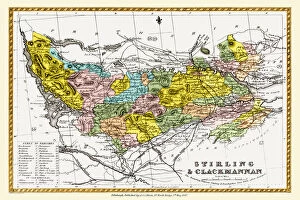
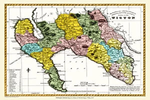
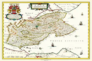
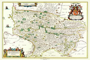
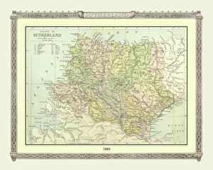
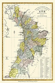
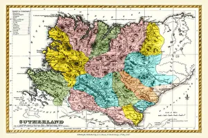
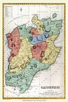
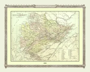
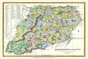
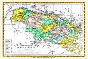
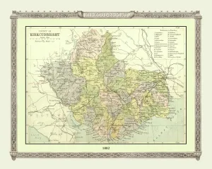
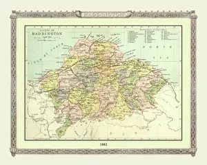
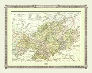
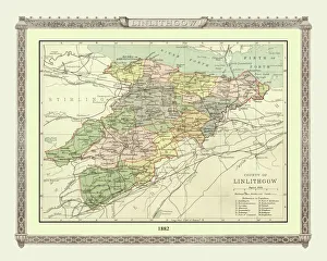
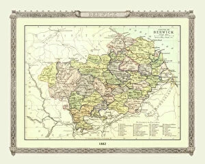
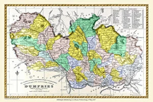
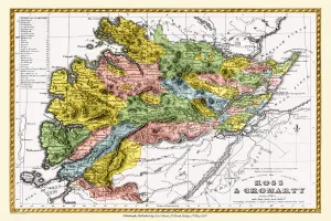
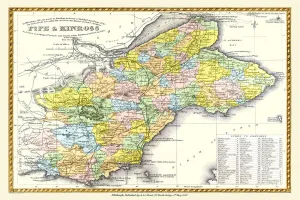
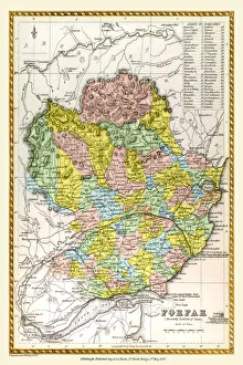
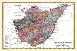
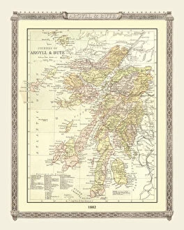
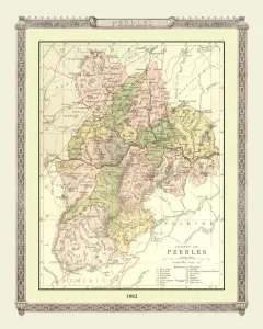
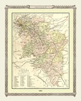
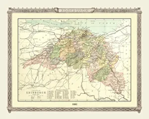
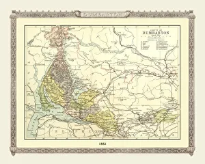
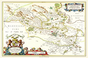
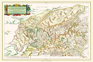
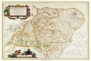
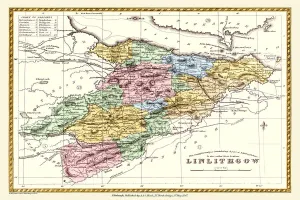
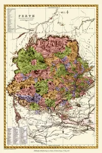
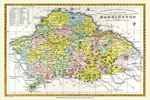
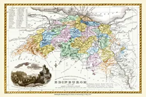
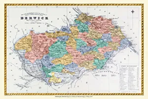
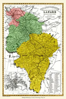
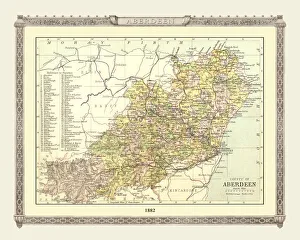
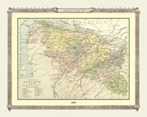
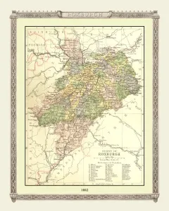
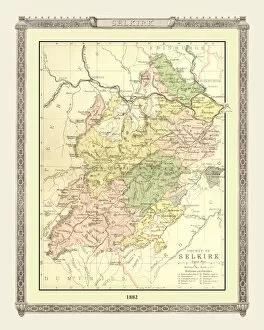
Step back in time with these stunning old Scottish county maps. From the Atlas Novus by Johan Blaeu, we have the Old County Map of Fife 1654 and the Old County Map of Kyle and Mid Ayrshire 1654. These intricate maps give us a glimpse into Scotland's past, showcasing the boundaries and features of these regions over three centuries ago. Moving forward to 1847, A&C Black brings us more historical gems. The Old County Map of Dunbartonshire (formerly called Dumbartonshire) reveals the landscape as it was during that era. Similarly, we have the Old County Map of Caithness Scotland and Dumfries Scotland from this collection, each capturing a unique snapshot of their respective areas. Continuing our journey through time, we arrive at another set of fascinating maps from 1882: Philips Handy Atlas presents us with an array of Scottish counties. Explore the Old Map of Aberdeen and Banff Scotland for a detailed look at these regions' topography during that period. Delve further into history with Philips Handy Atlas' offerings: The Old Maps showcase Kirkcudbright, Ross and Cromarty, Sutherland, Stirling and Clackmannan counties - all providing valuable insights into their landscapes long ago. Lastly but certainly not least is the captivating Old Map of Inverness from 1882. Discover how this historic county looked over a century ago before exploring Linlithgow's rich heritage through its own map from that same year. These they are not just pieces of cartographic art; they are windows into Scotland's past - allowing us to appreciate how much has changed while preserving our connection to those who came before us.