Fraud Blocker Skip to main content

Os Map Collection

"Exploring Sheffield's Past

Background imageOs Map Collection: Ordnance Survey Map, Sheffield, Netherthorpe area, 1889 (Yorkshire sheet 294. 7. 9)

Ordnance Survey Map, Sheffield, Netherthorpe area, 1889 (Yorkshire sheet 294. 7. 9)
This map features: Top left: Abbey Street, Springvale Road, Crookesmoor Road, Burlington Street, Martin Street, Wentworth Street, Adelphi Street, Oxford Street, Martin Lane, Sunday School

Background imageOs Map Collection: Ordnance Survey Map, Carlisle Street East and Savile Street East area, Sheffield

Ordnance Survey Map, Carlisle Street East and Savile Street East area, Sheffield, 1889 (Yorkshire sheet No. 294. 4. 24)
This map features: Top left: Bessemer Steel Works [Bessemer and Co. Ltd], Carlisle Street East; Midland Railway Goods Line; Atlas Steel and Iron Works [John Brown and Co]

Background imageOs Map Collection: Ordnance Survey Map, Sheffield, Bramwell Street / Netherthorpe area, 1889 (Yorkshire sheet 294. 7)

Ordnance Survey Map, Sheffield, Bramwell Street / Netherthorpe area, 1889 (Yorkshire sheet 294. 7. 14)
This map features: Top left: Fawcett Street, Daisy Bank, Bramwell Street, Powell Street, Radford Place, Bromley Street, St

Background imageOs Map Collection: Ordnance Survey Map, Sheffield, Edward Street / Netherthorpe area, 1889 (Yorkshire sheet 294. 7. 15)

Ordnance Survey Map, Sheffield, Edward Street / Netherthorpe area, 1889 (Yorkshire sheet 294. 7. 15)
This map features Top left: Hoyle Street, Dover Street, Morpeth Street, New Meadow Street, Craven Street, Well Meadow Street, Jericho Square, Upper Allen Street, Marsden Lane, Brocco Street

Background imageOs Map Collection: Ordnance Survey Map, Kelvin area of Sheffield, 1889 (Yorkshire sheet 294. 3. 24)

Ordnance Survey Map, Kelvin area of Sheffield, 1889 (Yorkshire sheet 294. 3. 24)
This map features: Top left: River Don, Clifton Hotel Public House, Wood Street, Lime Street, Bertha Street, Stone Road, Thirza Street, Gertrude Street, Flora Street, Langsett Road, Tramway

Background imageOs Map Collection: Ordnance Survey Map, Blonk Street area, 1890 (sheet no. Yorkshire No. 294.8.12)

Ordnance Survey Map, Blonk Street area, 1890 (sheet no. Yorkshire No. 294.8.12)
This map features: Top left: River Don, Blonk Goit, Wicker, Wire Works, Blonk Street, Water Lane, Castle Green, Waingate, Slaughter Houses, Mill Sands, Bridge Street, Tramway, Wicker, Gun Lane

Background imageOs Map Collection: Ordnance Survey Map, City Centre, 1890 (sheet no. Yorkshire No. 294.8.16)

Ordnance Survey Map, City Centre, 1890 (sheet no. Yorkshire No. 294.8.16)
This map features Top left: Campo Lane, Church Street, St. James Row Bank, Trippet Lane, Pinfold Street, Bow Street, Canterbury Hall Public House, Orchard Street, Leopold Street, Sims Croft

Background imageOs Map Collection: Ordnance Survey Map, Fitzalan Square area, 1889 (sheet no. Yorkshire No. 294.8.17)

Ordnance Survey Map, Fitzalan Square area, 1889 (sheet no. Yorkshire No. 294.8.17)
This map features: Top left: Watson's Walk [Watson Walk], Waterloo Turf Tavern, Commercial Street, Shude Hill, Shude Lane, Fish Market, [Marsh Brothers and Co.]

Background imageOs Map Collection: Ordnance Survey Map, Bernard Road area, 1890 (sheet no. Yorkshire No. 294.8.18)

Ordnance Survey Map, Bernard Road area, 1890 (sheet no. Yorkshire No. 294.8.18)
This map features Top left: Broad Street, Shrewsbury Works (metal) (in margin), Park Plate Works (in margin), Old Street, High Street Lane, Crown Alley Lane, Low Street, New Street Lane

Background imageOs Map Collection: Ordnance Survey Map, Brookhill area, Sheffield, 1889 (sheet no. Yorkshire No. 294.7.19)

Ordnance Survey Map, Brookhill area, Sheffield, 1889 (sheet no. Yorkshire No. 294.7.19)
This map features Top left: Weston Street, Yardley Street, Sutton Street, Bolsover Street, Brightmore Street, Mitchell Street, Winter Street, Lodge on Winter Street, Reliance Place, West Grove Place

Background imageOs Map Collection: Ordnance Survey Map, Sheffield, Bates Street area, Crookes, Sheffield, 1889 (Yorkshire sheet 294)

Ordnance Survey Map, Sheffield, Bates Street area, Crookes, Sheffield, 1889 (Yorkshire sheet 294. 7. 7)
This map features: Top left: Slinn Street, Old quarry, Townend Street, Mona Road, Bates Street, Heavy Gate Road, Sunnyside, Olivet Mount, Grasmere Villa, Belvoir House

Background imageOs Map Collection: Ordnance Survey Map, Sheffield, Cornish Street area, Netherthorpe, Sheffield

Ordnance Survey Map, Sheffield, Cornish Street area, Netherthorpe, Sheffield, 1889 (Yorkshire sheet 294. 7. 5)
This map features: Top left: Bedford Street, Burys and Co. Ltd. steel manufacturers, Regent Works, Penistone Road and Philadelphia Steel Works, Penistone Road / Bedford Street, Penistone Road

Background imageOs Map Collection: Ordnance Survey Map, Sheffield, Blake Street area, Netherthorpe, Sheffield

Ordnance Survey Map, Sheffield, Blake Street area, Netherthorpe, Sheffield, 1889 (Yorkshire sheet No. 294. 7. 3)
This map features: Top left: Daniel Hill Street, Elton Street, Harworth Street, Harworth Road, Walkley Street, Duncombe Street, Fulton Road, Blake Street Hotel Public House [Blake Hotel]

Background imageOs Map Collection: Ordnance Survey Map, Sheffield, Cromwell Street area, Walkley, Sheffield

Ordnance Survey Map, Sheffield, Cromwell Street area, Walkley, Sheffield, 1889 (Yorkshire sheet No. 294. 7. 2)
This map features: Top left: Fir Street, Hadfield Street, Fir Spring House, Cundy Street, South Road, St. Marys Church [Walkley], Grove Terrace, Eveline Terrace, Olivet Mount, Lorne House, The Grove

Background imageOs Map Collection: Ordnance Survey Map, Bessemer Road area, Attercliffe, Sheffield, 1889 (Yorkshire sheet No. 294. 4)

Ordnance Survey Map, Bessemer Road area, Attercliffe, Sheffield, 1889 (Yorkshire sheet No. 294. 4. 25)
This map features: Top left: River Don, Crown Steel and Wire Works, Bessemer Road [Arthur Lee and Sons Ltd. steel and wire manufacturers], Princess Street, Midland Railway, Savile Street East

Background imageOs Map Collection: Ordnance Survey Map, Gower Street area, Burngreave, Sheffield, 1889 (Yorkshire sheet No. 294. 4. 23)

Ordnance Survey Map, Gower Street area, Burngreave, Sheffield, 1889 (Yorkshire sheet No. 294. 4. 23)
This map features: Top left: Buckenham Road, Ditchingham Road, Catherine Road, Granville Street, Grimesthorpe Road, Bressinghham Road, Ellesmere Road, Clun Road, Petre Street, Buckenham Street

Background imageOs Map Collection: Ordnance Survey Map, West Bar area, Sheffield, 1889 (Yorkshire sheet 294. 8. 11)

Ordnance Survey Map, West Bar area, Sheffield, 1889 (Yorkshire sheet 294. 8. 11)
This map features: Top left: West Bar, tramway, Corporation Street, West Bar Green, Moseley's Arms Public House, Scotland Street, Crown Inn, Lambert Street, Steelhouse Lane, Furnace Hill

Background imageOs Map Collection: Ordnance Survey Map, Effingham Street area, Sheffield, 1889 (Yorkshire sheet 294. 8. 8)

Ordnance Survey Map, Effingham Street area, Sheffield, 1889 (Yorkshire sheet 294. 8. 8)
This map features: Top left: Goods shed, River Don, Effingham Street, Furnival Road, Wicker Brewery Hotel Public House, Savile Street, tramway, [George Turton, Platts and Co

Background imageOs Map Collection: Ordnance Survey Map, The Wicker / Spital Hill, Sheffield, 1889 (Yorkshire sheet 294. 8. 7)

Ordnance Survey Map, The Wicker / Spital Hill, Sheffield, 1889 (Yorkshire sheet 294. 8. 7)
This map features: Top left: Manchester, Sheffield and Lincolnshire Railway, Goods Shed, Brunswick Road, Andrew Street, [William Wright, mortar grinder]

Background imageOs Map Collection: Ordnance Survey Map, Alma Street / Netherthorpe area, Sheffield, 1889 (Yorkshire sheet 294. 8. 6)

Ordnance Survey Map, Alma Street / Netherthorpe area, Sheffield, 1889 (Yorkshire sheet 294. 8. 6)
This map features: Top left: Alma Street, River Don, [Taylor and Co. steam hammer manufacturers, ] Alma Street Works (Engineering), [Union Grinding Wheel Company] on Alma Street

Background imageOs Map Collection: Ordnance Survey Map, Attercliffe area, Sheffield, 1889 (Yorkshire sheet 294. 8. 4)

Ordnance Survey Map, Attercliffe area, Sheffield, 1889 (Yorkshire sheet 294. 8. 4)
This map features: Top left: [Charles Cammell and Co. Ltd. steel manufacturers], Cyclops Works (steel and iron), Sutherland Street / Saville Street East; [Spear and Jackson, Aetna Works]

Background imageOs Map Collection: Ordnance Survey Map, Sheffield, Eldon Street / West Street area, 1889 (Yorkshire sheet 294. 7. 25)

Ordnance Survey Map, Sheffield, Eldon Street / West Street area, 1889 (Yorkshire sheet 294. 7. 25)
This map features: Top left: West Street, Devonshire Street, Dawson Street, Eldon Brewery, Eldon Street, Eldon Lane, Broomhall Street, Eldon Street, Fitzwilliam Street, Reindeer Hotel Public House

Background imageOs Map Collection: Ordnance Survey Map, Broomhill area of Sheffield, 1889 (Yorkshire sheet 294. 7. 23)

Ordnance Survey Map, Broomhill area of Sheffield, 1889 (Yorkshire sheet 294. 7. 23)
This map features: Top left: Whitham Road, Wellesley Road, Damer Street, Claremont Crescent, Tree Root Walk, Northumberland Road, Durham House, Palmerston Road, Godfrey Dam Lodge, Westcliffe

Background imageOs Map Collection: Ordnance Survey Map, Sheffield, Portobello Street area (Yorkshire No. 294. 7. 20)

Ordnance Survey Map, Sheffield, Portobello Street area (Yorkshire No. 294. 7. 20)
This map features: Top left: Broad Lane, Boden Lane, Newcastle Street, Carr Lane, St. Thomas Street, West John Lane, West John Street, Firth College (Sheffield Technical School)

Background imageOs Map Collection: Ordnance Survey Map, Sheffield, School Road, Spring Hill Road area, 1889 (Yorkshire sheet 294. 7)

Ordnance Survey Map, Sheffield, School Road, Spring Hill Road area, 1889 (Yorkshire sheet 294. 7. 12)
This map features Top left: Old quarry, Hands Lane, Bowling Green on corner of Hands Lane and Townend Street, [Ramsey Road], [Leamington Street]

Background imageOs Map Collection: Ordnance Survey Map, Sheffield, Hoyle Street / Infirmary Road area, 1889 (Yorkshire sheet 294. 7)

Ordnance Survey Map, Sheffield, Hoyle Street / Infirmary Road area, 1889 (Yorkshire sheet 294. 7. 10)
This map features Top left: Watery Street, Henry Street, St. Phillips Road, Malinda Street, Sudbury Street, [Abram Brooksbank and Co.], Malinda Works, Malinda Street, steel and files; Progress Works


All Professionally Made to Order for Quick Shipping

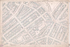
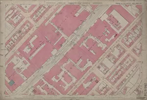
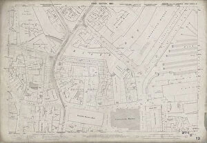
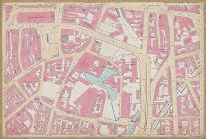
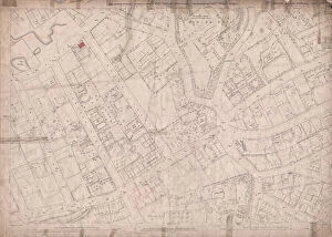
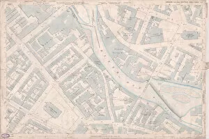
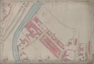
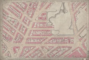
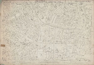
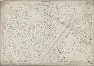
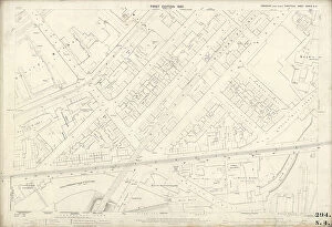
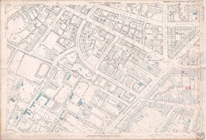
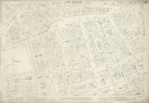
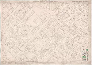
"Exploring Sheffield's Past: Unveiling the City through OS Maps" Step back in time to 1889 and immerse yourself in the rich history of Sheffield with these Ordnance Survey maps. Each map reveals a different area, offering glimpses into the city's vibrant past. Discover Edward Street/Netherthorpe, where bustling streets and lively markets once thrived (Yorkshire sheet 294. 15). Journey to West Bar, a hub of activity and commerce that shaped the city's growth (Yorkshire sheet 294. 11). Delve into Effingham Street, an area teeming with life and community spirit (Yorkshire sheet 294. 8). Explore The Wicker/Spital Hill, where historic landmarks stood tall amidst a thriving industrial landscape (Yorkshire sheet 294. 7). Uncover Alma Street/Netherthorpe, witnessing how this neighborhood evolved over time (Yorkshire sheet 294. 6). Traverse Attercliffe, once home to steelworks and factories that powered Sheffield's industrial might (Yorkshire sheet 294. 4). Marvel at Eldon Street/West Street, capturing the essence of urban development in Victorian times (Yorkshire sheet 294. 25). Wander through Broomhill, an elegant suburb adorned with grand houses and leafy avenues (Yorkshire sheet 294-7-23). Explore Portobello Street area – witness its transformation from humble beginnings to a vibrant community hub (Yorkshire No. 294-7-20). Immerse yourself in Carlisle Street East/Savile Street East; experience the pulse of trade and industry within its boundaries (Yorkshie Sheet No. 284 -4 -24) Venture into Kelvin – discover its hidden gems nestled among picturesque landscapes (Yorkshie Sheet No.