Fraud Blocker Skip to main content

Us State Border Collection

"Exploring the Intricate Tapestry of US State Borders

Background imageUs State Border Collection: Iowa 1852 Map

Iowa 1852 Map

Background imageUs State Border Collection: Illinois 1852 Map

Illinois 1852 Map

Background imageUs State Border Collection: 1883 Ohio State Map

1883 Ohio State Map

Background imageUs State Border Collection: Vermont 1852 Map

Vermont 1852 Map

Background imageUs State Border Collection: Ohio 1852 Map

Ohio 1852 Map

Background imageUs State Border Collection: Wisconsin 1852 Map

Wisconsin 1852 Map

Background imageUs State Border Collection: Map of the northern part of Missouri, c.1900 (engraving)

Map of the northern part of Missouri, c.1900 (engraving)
533200 Map of the northern part of Missouri, c.1900 (engraving); (add.info.: Map of the northern part of Missouri with inset maps of Kansas City and St)

Background imageUs State Border Collection: Map of Nebraska with inset of Omaha, c.1900 (engraving)

Map of Nebraska with inset of Omaha, c.1900 (engraving)
533197 Map of Nebraska with inset of Omaha, c.1900 (engraving); (add.info.: Map of Nebraska, United States, with an inset map of Omaha, circa 1902)

Background imageUs State Border Collection: Map of Kentucky, c.1900 (engraving)

Map of Kentucky, c.1900 (engraving)
533143 Map of Kentucky, c.1900 (engraving); (add.info.: Map of Kentucky, United States, circa 1902, from the 10th edition of Encyclopaedia Britannica.); Encyclopaedia Britannica/UIG

Background imageUs State Border Collection: Map of Pennsylvania with inset map of Philadelphia, c.1900 (engraving)

Map of Pennsylvania with inset map of Philadelphia, c.1900 (engraving)
533115 Map of Pennsylvania with inset map of Philadelphia, c.1900 (engraving); (add.info.: Map of eastern Pennsylvania with inset map of Philadelphia, circa 1902)

Background imageUs State Border Collection: Map of New York State, c.1900 (engraving)

Map of New York State, c.1900 (engraving)
533109 Map of New York State, c.1900 (engraving); (add.info.: Map of western New York State, with inset map of Buffalo, Niagara Frontier, and Rochester, circa 1902)

Background imageUs State Border Collection: Map of New York State, c.1900 (engraving)

Map of New York State, c.1900 (engraving)
533104 Map of New York State, c.1900 (engraving); (add.info.: Map of southern New York State, United States, insets map of New York City, the Hudson River, and the Catskill Mountains, circa 1902)

Background imageUs State Border Collection: Map of the Catskill Mountains, New York, c.1900 (engraving)

Map of the Catskill Mountains, New York, c.1900 (engraving)
533423 Map of the Catskill Mountains, New York, c.1900 (engraving); (add.info.: Map of Catskill Mountains, New York, circa 1902)

Background imageUs State Border Collection: Map of Nevada and Utah, c.1900 (engraving)

Map of Nevada and Utah, c.1900 (engraving)
533228 Map of Nevada and Utah, c.1900 (engraving); (add.info.: Map of Nevada and Utah, United States, with an inset map of Salt Lake City, circa 1902)

Background imageUs State Border Collection: Map of Colorado, c.1900 (engraving)

Map of Colorado, c.1900 (engraving)
533216 Map of Colorado, c.1900 (engraving); (add.info.: Map of Colorado, United States, circa 1902, from the 10th edition of Encyclopaedia Britannica.); Encyclopaedia Britannica/UIG

Background imageUs State Border Collection: Map of Montana, c.1900 (engraving)

Map of Montana, c.1900 (engraving)
533209 Map of Montana, c.1900 (engraving); (add.info.: Map of Montana, United States, circa 1902, from the 10th edition of Encyclopaedia Britannica.); Encyclopaedia Britannica/UIG

Background imageUs State Border Collection: Map of Oklahoma and the Indian Territory, c.1900 (engraving)

Map of Oklahoma and the Indian Territory, c.1900 (engraving)
533207 Map of Oklahoma and the Indian Territory, c.1900 (engraving); (add.info.: Map of Oklahoma and the Indian Territory, United States, circa 1902)

Background imageUs State Border Collection: Map of Iowa, c.1900 (engraving)

Map of Iowa, c.1900 (engraving)
533195 Map of Iowa, c.1900 (engraving); (add.info.: Map of Iowa, United States, circa 1902, from the 10th edition of Encyclopaedia Britannica.); Encyclopaedia Britannica/UIG

Background imageUs State Border Collection: Map of northern Ohio, c.1900 (engraving)

Map of northern Ohio, c.1900 (engraving)
533164 Map of northern Ohio, c.1900 (engraving); (add.info.: Map of the northern part of Ohio, United States, circa 1902, from the 10th edition of Encyclopaedia Britannica)

Background imageUs State Border Collection: Map of Alabama, c.1900 (engraving)

Map of Alabama, c.1900 (engraving)
533151 Map of Alabama, c.1900 (engraving); (add.info.: Map of Alabama, United States, circa 1902, from the 10th edition of Encyclopaedia Britannica.); Encyclopaedia Britannica/UIG

Background imageUs State Border Collection: Map of Washington State, c.1900 (engraving)

Map of Washington State, c.1900 (engraving)
533220 Map of Washington State, c.1900 (engraving); (add.info.: Map of Washington State, United States, circa 1902, from the 10th edition of Encyclopaedia Britannica.); Encyclopaedia Britannica/UIG

Background imageUs State Border Collection: Map of Minnesota, c.1900 (engraving)

Map of Minnesota, c.1900 (engraving)
533188 Map of Minnesota, c.1900 (engraving); (add.info.: Map of Minnesota, United States, with inset maps of Duluth and Minneapolis, circa 1902)

Background imageUs State Border Collection: Map of eastern Texas, c.1900 (engraving)

Map of eastern Texas, c.1900 (engraving)
533161 Map of eastern Texas, c.1900 (engraving); (add.info.: Map of the eastern part of Texas, circa 1902, from the 10th edition of Encyclopaedia Britannica.); Encyclopaedia Britannica/UIG

Background imageUs State Border Collection: Map of eastern Tennessee, c.1900 (engraving)

Map of eastern Tennessee, c.1900 (engraving)
533145 Map of eastern Tennessee, c.1900 (engraving); (add.info.: Map of the eastern part of Tennessee with inset map of Chattanooga, circa 1902)

Background imageUs State Border Collection: Map of North Carolina, c.1900 (engraving)

Map of North Carolina, c.1900 (engraving)
533130 Map of North Carolina, c.1900 (engraving); (add.info.: Map of North Carolina, United States, circa 1902, from the 10th edition of Encyclopaedia Britannica.); Encyclopaedia Britannica/UIG

Background imageUs State Border Collection: Map of northern Illinois, c.1900 (engraving)

Map of northern Illinois, c.1900 (engraving)
533173 Map of northern Illinois, c.1900 (engraving); (add.info.: Map of the northern part of Illinois, United States, circa 1902)

Background imageUs State Border Collection: Map of South Carolina with inset of Charleston, c.1900 (engraving)

Map of South Carolina with inset of Charleston, c.1900 (engraving)
533136 Map of South Carolina with inset of Charleston, c.1900 (engraving); (add.info.: Map showing the historical boundaries of South Carolina, United States, with an inset map of Charleston)

Background imageUs State Border Collection: Map of Vermont and New Hampshire, c.1900 (engraving)

Map of Vermont and New Hampshire, c.1900 (engraving)
533091 Map of Vermont and New Hampshire, c.1900 (engraving); (add.info.: Map showing the historical boundaries of Vermont and New Hampshire, United States, circa 1902)

Background imageUs State Border Collection: Map of Wisconsin, c.1900 (engraving)

Map of Wisconsin, c.1900 (engraving)
533185 Map of Wisconsin, c.1900 (engraving); (add.info.: Map of Wisconsin, United States, with an inset map of Milwaukee and the Waukesha Lake Region, circa 1902)

Background imageUs State Border Collection: Map of the northern part of Michigan, c.1900 (engraving)

Map of the northern part of Michigan, c.1900 (engraving)
533181 Map of the northern part of Michigan, c.1900 (engraving); (add.info.: Map of the northern part of Michigan, United States, with inset maps of St)

Background imageUs State Border Collection: Map of southern Ohio, c.1900 (engraving)

Map of southern Ohio, c.1900 (engraving)
533168 Map of southern Ohio, c.1900 (engraving); (add.info.: Map of the southern part of Ohio, United States, with inset maps of Cincinnati and Cleveland, circa 1902)

Background imageUs State Border Collection: Map of Mississippi, c.1900 (engraving)

Map of Mississippi, c.1900 (engraving)
533154 Map of Mississippi, c.1900 (engraving); (add.info.: Map of Mississippi, United States, circa 1902, from the 10th edition of Encyclopaedia Britannica.); Encyclopaedia Britannica/UIG

Background imageUs State Border Collection: Map of Georgia, c.1900 (engraving)

Map of Georgia, c.1900 (engraving)
533139 Map of Georgia, c.1900 (engraving); (add.info.: Map of Georgia, United States, with inset maps of Savannah and Chickamauga National Park, circa 1902)

Background imageUs State Border Collection: Map of Maryland and Delaware, c.1900 (engraving)

Map of Maryland and Delaware, c.1900 (engraving)
533120 Map of Maryland and Delaware, c.1900 (engraving); (add.info.: Map of Maryland and Delaware, inset maps of District of Columbia and Baltimore, circa 1902)

Background imageUs State Border Collection: Map of New York State, c.1900 (engraving)

Map of New York State, c.1900 (engraving)
533105 Map of New York State, c.1900 (engraving); (add.info.: Map of north and eastern New York State, United States, circa 1902)

Background imageUs State Border Collection: Map of Connecticut and Rhode Island, c.1900 (engraving)

Map of Connecticut and Rhode Island, c.1900 (engraving)
533101 Map of Connecticut and Rhode Island, c.1900 (engraving); (add.info.: Map of Connecticut and Rhode Island, United States, with an inset of Newport, circa 1902)

Background imageUs State Border Collection: Map of Maine, c.1900 (engraving)

Map of Maine, c.1900 (engraving)
533088 Map of Maine, c.1900 (engraving); (add.info.: Map of Maine, United States, with inset map of Mount Desert Island, circa 1902)

Background imageUs State Border Collection: Map of southern Illinois, c.1900 (engraving)

Map of southern Illinois, c.1900 (engraving)
533175 Map of southern Illinois, c.1900 (engraving); (add.info.: Map of the southern part of Illinois, United States, with an inset map of Chicago and Vicinity, circa 1902)

Background imageUs State Border Collection: Map of Indiana, c.1900 (engraving)

Map of Indiana, c.1900 (engraving)
533170 Map of Indiana, c.1900 (engraving); (add.info.: Map of Indiana, United States, circa 1902, from the 10th edition of Encyclopaedia Britannica.); Encyclopaedia Britannica/UIG

Background imageUs State Border Collection: Map of western Texas with Galveston, c.1900 (engraving)

Map of western Texas with Galveston, c.1900 (engraving)
533163 Map of western Texas with Galveston, c.1900 (engraving); (add.info.: Map of the western part of Texas with inset map of Galveston Bay, Galveston, Houston and Vicinity, circa 1902)

Background imageUs State Border Collection: Map of Arkansas, c.1900 (engraving)

Map of Arkansas, c.1900 (engraving)
533157 Map of Arkansas, c.1900 (engraving); (add.info.: Map of Arkansas, United States, circa 1902, from the 10th edition of Encyclopaedia Britannica.); Encyclopaedia Britannica/UIG

Background imageUs State Border Collection: Map of the southern part of California, c.1900 (engraving)

Map of the southern part of California, c.1900 (engraving)
533233 Map of the southern part of California, c.1900 (engraving); (add.info.: Map of the southern part of California, United States, with inset maps of Los Angeles, San Diego)

Background imageUs State Border Collection: Map of the northern part of California, c.1900 (engraving)

Map of the northern part of California, c.1900 (engraving)
533231 Map of the northern part of California, c.1900 (engraving); (add.info.: Map of the northern part of California, United States, with inset maps of San Francisco and Yosemite Valley, circa 1902)

Background imageUs State Border Collection: Map of Oregon, c.1900 (engraving)

Map of Oregon, c.1900 (engraving)
533223 Map of Oregon, c.1900 (engraving); (add.info.: Map of Oregon, United States, circa 1902, from the 10th edition of Encyclopaedia Britannica.); Encyclopaedia Britannica/UIG

Background imageUs State Border Collection: Map of Kansas, c.1900 (engraving)

Map of Kansas, c.1900 (engraving)
533205 Map of Kansas, c.1900 (engraving); (add.info.: Map of Kansas, United States, circa 1902, from the 10th edition of Encyclopaedia Britannica.); Encyclopaedia Britannica/UIG

Background imageUs State Border Collection: Map of the southern part of Missouri, c.1900 (engraving)

Map of the southern part of Missouri, c.1900 (engraving)
533203 Map of the southern part of Missouri, c.1900 (engraving); (add.info.: Map of the southern part of Missouri, United States, circa 1902)

Background imageUs State Border Collection: Map of Florida with insets of cities, c.1900 (engraving)

Map of Florida with insets of cities, c.1900 (engraving)
533142 Map of Florida with insets of cities, c.1900 (engraving); (add.info.: Map of Florida, United States, with inset maps of Jacksonville, Tampa, St)

Background imageUs State Border Collection: Map of Pennsylvania, with inset map of Pittsburg, c.1900 (engraving)

Map of Pennsylvania, with inset map of Pittsburg, c.1900 (engraving)
533118 Map of Pennsylvania, with inset map of Pittsburg, c.1900 (engraving); (add.info.: Map of Pennsylvania, with inset map of Pittsburg, circa 1902)


All Professionally Made to Order for Quick Shipping

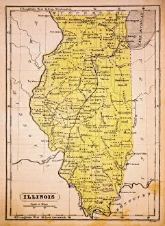
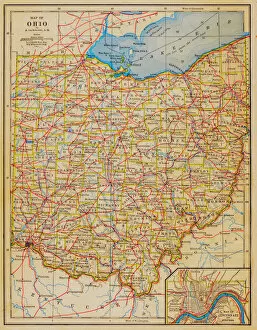
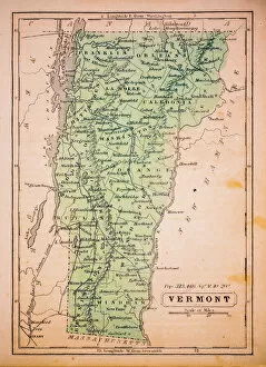
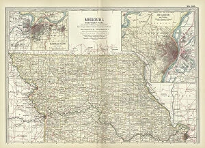
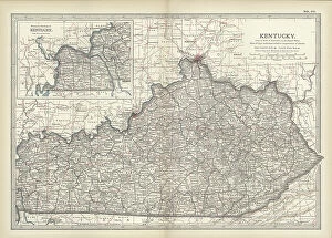
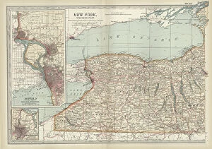
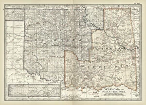
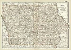
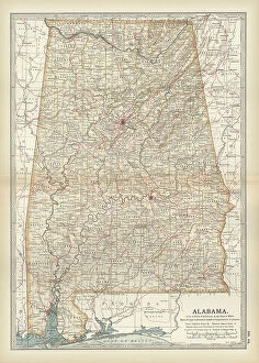
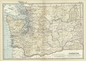
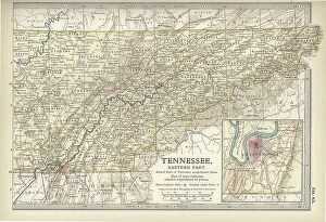
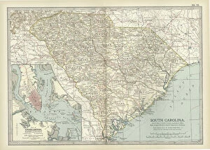
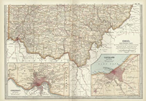
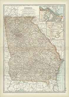
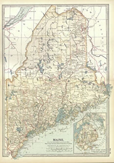
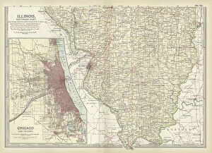
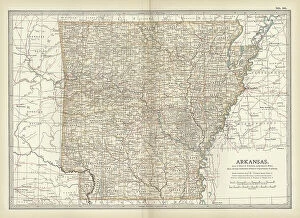
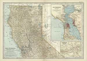
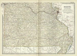
"Exploring the Intricate Tapestry of US State Borders: A Glimpse into 1852 Maps" Step back in time and embark on a journey through the fascinating world of US state borders with these captivating maps from 1852. Delve into the rich history and intricate details that shaped our nation's boundaries. The Iowa 1852 Map reveals the birth of a Midwestern gem, showcasing its evolving shape as it emerged as an independent state. Meanwhile, the Illinois 1852 Map showcases this vibrant state's expansion during a pivotal era. Travel further east with the Vermont 1852 Map, where you can witness its picturesque contours taking form amidst lush landscapes. The Ohio 1852 Map provides insights into this bustling hub's growth and development over time, while the Michigan 1852 Map unveils its unique silhouette within America's Great Lakes region. Venturing westward, explore Wisconsin's transformation through its distinct borders captured in the Wisconsin 1852 Map. These maps offer glimpses into how states were meticulously carved out to create diverse regions across America. Zooming out for a broader perspective, immerse yourself in the grandeur of a general reference map of USA from that era. Observe Washington D. C. , highlighted in red like a beacon representing our nation's capital on this historic treasure trove known as "Map of USA. " Expand your horizons even further by exploring Western Hemisphere through an enchanting map from 1852. Witness how countries intertwined their borders to form connections that transcend geographical boundaries. Closer to home, dive into New England’s past with Maine and Massachusetts' respective maps from 1852. Discover how these states evolved alongside their neighboring counterparts throughout centuries-old struggles and triumphs. These remarkable maps serve as portals to another time – windows revealing stories etched upon every border line drawn with precision and purpose. They remind us that behind each boundary lies tales of exploration, settlement, and the pursuit of a united nation.