
Was An English Cartographer Collection
John Cary (1754 - 1835) was an English cartographer who left a lasting impact on the field of mapmaking


All Professionally Made to Order for Quick Shipping
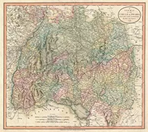
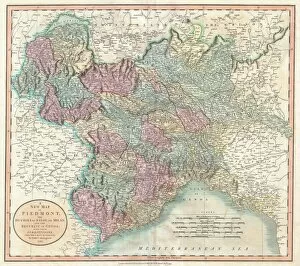
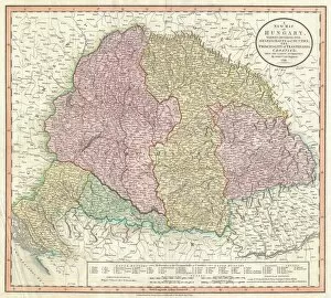
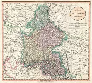
John Cary (1754 - 1835) was an English cartographer who left a lasting impact on the field of mapmaking. In 1799, he produced several remarkable maps that showcased his exceptional skills and attention to detail. One such masterpiece is the Cary Map of the Upper and Lower Rhine. This intricately crafted map provided a comprehensive view of the region, highlighting its geographical features and important landmarks. With this creation, Cary demonstrated his ability to accurately depict complex landscapes. Another notable work by John Cary in 1799 was the Cary Map of Tyrol. This map captured the beauty and diversity of this Austrian region, showcasing its mountainous terrain and charming towns. It served as a valuable resource for travelers seeking to explore Tyrol's hidden gems. Cary's expertise extended beyond Europe as well. His 1799 Cary Map of the Russian Empire depicted this vast nation with precision, offering insight into its expansive territories and diverse cultures. Through meticulous research and mapping techniques, he presented an accurate representation of Russia during that time period. The Netherlands also found its place on one of John Cary's maps in 1799. The intricate details showcased in his depiction revealed not only major cities like Amsterdam but also smaller towns nestled along canals and rivers—a testament to his dedication to accuracy at every scale. Cary's talent for capturing regions' essence continued with his portrayal of Prussia and Lithuania on another map from that year. By skillfully illustrating their borders, cities, and natural features, he provided invaluable knowledge about these historically significant areas. Italy too received special attention from John Cary in 1799 through two separate maps: one featuring Italy as a whole; another focusing specifically on Piedmont—highlighting Milan and Genoa—and Mantua, Venice, and Tyrol respectively. These works exemplified his ability to showcase both larger regions' complexities while zooming in on specific areas with equal precision.