Fraud Blocker Skip to main content

Western Hemisphere Collection

Exploring the vast wonders of the Western Hemisphere, we embark on a journey through time and space

Background imageWestern Hemisphere Collection: 17th century map of the New World

17th century map of the New World
Western Hemisphere, 17th century Dutch map. This shows the New World that was being discovered by Europeans exploring the Western Hemisphere of the Earth

Background imageWestern Hemisphere Collection: 17th century map of the New World

17th century map of the New World

Background imageWestern Hemisphere Collection: A 3D conceptual image of the world at your fingertips

A 3D conceptual image of the world at your fingertips

Background imageWestern Hemisphere Collection: Antarctica, Antarctic Peninsula, Port Lockroy

Antarctica, Antarctic Peninsula, Port Lockroy. Gentoo penguins (Pygoscelis papua) and Cruise Ship Clipper Adventurer

Background imageWestern Hemisphere Collection: MONROE DOCTRINE CARTOON. Uncle Sam straddles the Americas while wielding a big stick labeled

MONROE DOCTRINE CARTOON. Uncle Sam straddles the Americas while wielding a big stick labeled Monroe Doctrine. American cartoon by Louis Dalrymple, 1905

Background imageWestern Hemisphere Collection: Saint Rose of Lima (Santa Rosa de Lima), Peru, 2015. Creator: Luis Rosendo

Saint Rose of Lima (Santa Rosa de Lima), Peru, 2015. Creator: Luis Rosendo
Chapel St. Rose of Lima, (Spanish Santa Rosa de Lima), Peru. St. Rose of Lima (born April 20/30, 1586, Lima, Viceroyalty of Peru [now in Peru])

Background imageWestern Hemisphere Collection: Western Hemisphere map

Western Hemisphere map - Scanned 1880 Engraving

Background imageWestern Hemisphere Collection: Map of Western hemisphere 1871

Map of Western hemisphere 1871
Colton and Fitchs Introductory School Geography - New York: Sheldon and Company 1871

Background imageWestern Hemisphere Collection: Earth from space, photographed by spacecraft Apollo 16, April 16 1972

Earth from space, photographed by spacecraft Apollo 16, April 16 1972. Most of the USA and Mexico and some parts of Central America are visible. Credit ARPL/NASA

Background imageWestern Hemisphere Collection: French Map of Central and South America, French, 1550

French Map of Central and South America, French, 1550. Map showing Florida, the Gulf of Mexico, the Caribbean islands and Antilles, and South America with the River Plate prominent

Background imageWestern Hemisphere Collection: 3D rendering of planet Earth, centered on South America

3D rendering of planet Earth, centered on South America
3D rendering of planet Earth with clouds, centered on South America

Background imageWestern Hemisphere Collection: World map dating from the late 17th or early 18th century and published in Amsterdam showing

World map dating from the late 17th or early 18th century and published in Amsterdam showing the western and eastern hemispheres. Amongst many inaccuracies, the California area is shown as an island

Background imageWestern Hemisphere Collection: Old, Map of Eastern and Western Hemispheres, From 1875

Old, Map of Eastern and Western Hemispheres, From 1875
Old black and white illustration of the Eastern Hemisphere and the Western Hemisphere, from the 1800 s

Background imageWestern Hemisphere Collection: An Urban Landscape

An Urban Landscape
This urban landscape depicts the European city of Amsterdam, The Netherlands. This image includes a canal in the foreground, a houseboat in the middle, and gabled architecture in the background

Background imageWestern Hemisphere Collection: An Amsterdam Canal

An Amsterdam Canal
This urban landscape depicts a water canal in the city center of Amsterdam, Netherlands. The landscape includes a water canal, houseboats, and gabled architectural buildings

Background imageWestern Hemisphere Collection: The UNESCO Recognized Canals of Amsterdam

The UNESCO Recognized Canals of Amsterdam
The unique and beautiful canals of central Amsterdam, The Netherlands are recognized by UNESCO as a World Heritage Site. This canal is characterized by its houseboats

Background imageWestern Hemisphere Collection: An Amsterdam Canal Bridge

An Amsterdam Canal Bridge
The Papiermolensluis is one of many historic canal bridges in Amsterdam, Netherlands. Due to its uniqueness, the canal ring in Amsterdam is now recognized by UNESCO as a World Heritage Site

Background imageWestern Hemisphere Collection: Western hemisphere of the Earth during the Early Jurassic period

Western hemisphere of the Earth during the Early Jurassic period
This is how the western hemisphere of the Earth may have appeared 200 million years ago during the Early Jurassic period. North is at the top

Background imageWestern Hemisphere Collection: 3D rendering of planet Earth, centered on North America and South America

3D rendering of planet Earth, centered on North America and South America

Background imageWestern Hemisphere Collection: Full Earth showing North America (white background)

Full Earth showing North America (white background)

Background imageWestern Hemisphere Collection: Antarctica, Weddell Sea, Atka Bay

Antarctica, Weddell Sea, Atka Bay. Emperor Penguins (Aptenodytes forsteri) & Russian Icebreaker Kapitan Khlebnikov Antarctica, Weddell Sea, Atka Bay

Background imageWestern Hemisphere Collection: Antarctica, Antarctic Penisula, Antarctic Sound

Antarctica, Antarctic Penisula, Antarctic Sound. Sailing through the sound otherwise known as Iceberg Alley Australian artist Noel Miller captures the scene. (MR)

Background imageWestern Hemisphere Collection: Antarctic, Antarctic Peninsula, Hope Bay

Antarctic, Antarctic Peninsula, Hope Bay. Wilsons Storm Petrel (Oceanites oceanicus) seems to walk across the surface of the water as it searches for its favourite food - plankton

Background imageWestern Hemisphere Collection: Antarctica, Antarctic Penisula

Antarctica, Antarctic Penisula. The sketch pad of Australian artist Noel Miller on the bridge of the expedition ship the MV Discovery as it makes it way down the Antarctic Sounds otherwise known as

Background imageWestern Hemisphere Collection: Antarctica, Antarctic Peninsula

Antarctica, Antarctic Peninsula. The chart room on the bridge of the expedition ship MV Discovery, the navigator plots a course through the maze of islands that make up the Antarctic Peninsula

Background imageWestern Hemisphere Collection: Western Hemisphere map 1881

Western Hemisphere map 1881
Harpers School Geography, New York, Harpers and Brothers, 1881

Background imageWestern Hemisphere Collection: 1879, Meiji 12 Japanese Map of North America and South America, Western Hemisphere

1879, Meiji 12 Japanese Map of North America and South America, Western Hemisphere

Background imageWestern Hemisphere Collection: 1747, Bowen Map of North America and South America, Western Hemisphere, topography

1747, Bowen Map of North America and South America, Western Hemisphere, topography
1747, Bowen Map of North America and South America, Western Hemisphere

Background imageWestern Hemisphere Collection: Western Hemisphere 1852 Map

Western Hemisphere 1852 Map

Background imageWestern Hemisphere Collection: Amsterdam Bicycle Culture

Amsterdam Bicycle Culture
In Amsterdam, the usage of bicycles as a form of public transportation is encourage and promoted by the Dutch government

Background imageWestern Hemisphere Collection: Escaramuzas Demonstrating Their Equestrian Skills

Escaramuzas Demonstrating Their Equestrian Skills
The Latinas are demonstrating their riding skill at a fiesta in San Antonio, Texas. This riding tradition originated in Mexico and is part of Mexican-American culture in the United States

Background imageWestern Hemisphere Collection: The Iconic Bicycle Culture of Urban Amsterdam

The Iconic Bicycle Culture of Urban Amsterdam
In the Netherlands, the bicycle is an important and essential part of Dutch culture. In the capital city of Amsterdam the bicycle is the major mode of transportation for its population

Background imageWestern Hemisphere Collection: The Colorful Tulips of Holland

The Colorful Tulips of Holland
These colorful tulips on public display in central Amstetdam represent the national flower of the Netherlands. Tulips are perennial flowers that are grown from a bulb

Background imageWestern Hemisphere Collection: A Bicycle Culture That Moves Amsterdam

A Bicycle Culture That Moves Amsterdam
In Amsterdam, bicycles are a way of life and a great part of the urban landscape. This bike is stationed on a canal bridge because parking space is scarce

Background imageWestern Hemisphere Collection: An Urban Houseboat in Amsterdam

An Urban Houseboat in Amsterdam
This urban houseboat is moored on a canal in Amsterdam, Netherlands. Houseboats are utilized as residential housing in this unique setting

Background imageWestern Hemisphere Collection: Full Earth view showing water vapor over the Americas

Full Earth view showing water vapor over the Americas

Background imageWestern Hemisphere Collection: A global view over North America with Arctic sea ice

A global view over North America with Arctic sea ice shown on April 8, 2006. Land areas display the average seasonal landcover from April, 2004

Background imageWestern Hemisphere Collection: Full Earth showing various tropical storms

Full Earth showing various tropical storms
August 22, 2014 - Full Earth showing Tropical Storm Lowell, Tropical Storm Karina, and Tropical Storm Marie

Background imageWestern Hemisphere Collection: A view of the Earth with the full Arctic region visible

A view of the Earth with the full Arctic region visible
September 21, 2005 - A view of the Earth with the full Arctic region visible

Background imageWestern Hemisphere Collection: Tropical storms on planet Earth

Tropical storms on planet Earth
July 22, 2011 - Tropical storms on planet Earth


All Professionally Made to Order for Quick Shipping

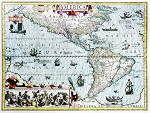
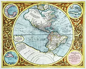
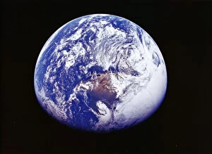
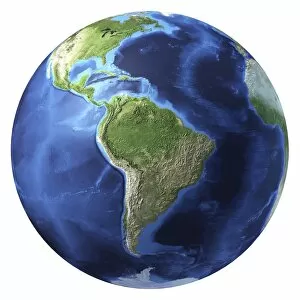
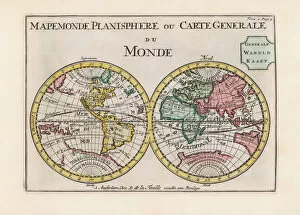
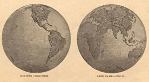
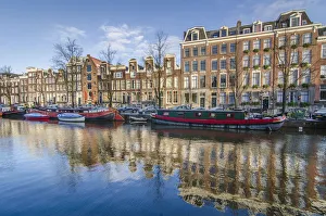
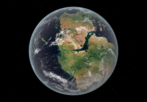
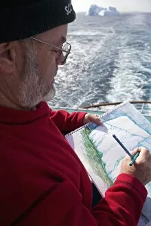
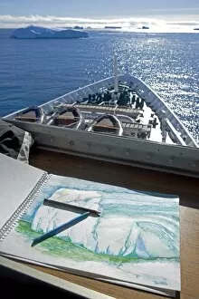
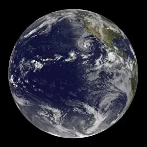
Exploring the vast wonders of the Western Hemisphere, we embark on a journey through time and space. A 17th-century map of the New World transports us to an era of discovery, where intrepid explorers set sail in search of new lands and treasures. As we navigate this historical cartographic masterpiece, we marvel at its intricate details and imagine the excitement that must have filled those early adventurers. Transitioning from ancient maps to modern technology, a 3D conceptual image brings the world to our fingertips. With just a swipe or tap, we can explore every corner of this hemisphere - from Antarctica's icy landscapes to the vibrant Antarctic Peninsula with its majestic Port Lockroy. Shifting our focus from nature's wonders to human creations, an urban landscape emerges before us. An Amsterdam canal captures our attention as it winds through picturesque buildings and bridges, reflecting centuries-old architectural splendor. Delving into political history, a thought-provoking cartoon depicts Uncle Sam straddling both Americas while brandishing a big stick labeled Monroe Doctrine. This iconic representation reminds us of America's influential role in shaping policies across the Western Hemisphere during the early 20th century. Turning towards spirituality, Saint Rose of Lima appears before us—a symbol of devotion and faith in Peru. Her presence serves as a reminder that religion has played an integral part in shaping cultures throughout this hemisphere for centuries. Returning to maps once more, we encounter various depictions showcasing different eras: a Western Hemisphere map illustrating geopolitical boundaries; another from 1871 offering insights into past territorial divisions; and even one captured by Apollo 16 astronauts—an awe-inspiring view of Earth from space—reminding us how interconnected our planet truly is. Lastly, we stumble upon an exquisite French map dating back to 1550 which showcases Central and South America with meticulous detail—a testament to cartographers' artistry during that period. These captivating hints invite us on an extraordinary voyage through time, space, and human imagination.