Fraud Blocker Skip to main content

World Map Collection

"Exploring the Rich Tapestry of Our World

Background imageWorld Map Collection: EXPL2A-00352

EXPL2A-00352
The Hereford Mappa Mundi of 1280 - Jerusalem is at the center, Europe lower left, Africa lower right. Printed color halftone reproduction 19th century

Background imageWorld Map Collection: Blue map of USA and the Caribbean sea

Blue map of USA and the Caribbean sea
Rosana Laiz Blursbyai

Background imageWorld Map Collection: Political Map of Africa

Political Map of Africa
Vector Illustration of the policital map of Africa Reference map as created by the US Central Intelligence Agency

Background imageWorld Map Collection: Mappa Mundi, c. 1290 (vellum)

Mappa Mundi, c. 1290 (vellum)
BAL62567 Mappa Mundi, c.1290 (vellum) by Richard of Haldingham (Richard de Bello) (fl.c.1260-1305); Hereford Cathedral, Herefordshire, UK; English, out of copyright

Background imageWorld Map Collection: Map of Ireland 1897

Map of Ireland 1897
Map of Ireland

Background imageWorld Map Collection: Hereford mappa mundi (world map)

Hereford mappa mundi (world map)
3849688 Hereford mappa mundi (world map) by Richard of Haldingham (Richard de Bello) (fl.c.1260-1305); 158x133 cm; (add.info.: Hereford mappa mundi (world map)

Background imageWorld Map Collection: Old Caucasus map

Old Caucasus map
Antique map of Caucasus

Background imageWorld Map Collection: Old Map of the World 1980

Old Map of the World 1980
WMY1980

Background imageWorld Map Collection: Anglo-Saxon 10th century world map

Anglo-Saxon 10th century world map
Anglo-Saxon world map, dating from the 10th century. East is top. This map of the known world was probably produced by an Irish monk

Background imageWorld Map Collection: British Empire world map, 19th century

British Empire world map, 19th century
British Empire world map. This world map shows the 19th-century British Empire (pink) and its indigenous peoples. Five illustrations (clockwise from upper left) show the people of Australia

Background imageWorld Map Collection: The Mappa Mundi of Fra Mauro, a Camaldolese monk from the monastery of San Michele in Murano, 1459

The Mappa Mundi of Fra Mauro, a Camaldolese monk from the monastery of San Michele in Murano, 1459
ALI75764 The Mappa Mundi of Fra Mauro, a Camaldolese monk from the monastery of San Michele in Murano, 1459 by Italian School, (15th century); Palazzo Ducale, Venice, Italy; Alinari

Background imageWorld Map Collection: Old Map of the World 1963

Old Map of the World 1963
WMY1963

Background imageWorld Map Collection: Map of the Word with lines marking boundaries of tectonic plates

Map of the Word with lines marking boundaries of tectonic plates

Background imageWorld Map Collection: Political map of The Middle East

Political map of The Middle East
Vector illustration of the policital map of The Middle East Reference map was created by the US Central Intelligence Agency

Background imageWorld Map Collection: The Babylonian Map of the World, c. 510-c. 500 BC. Artist: Assyrian Art

The Babylonian Map of the World, c. 510-c. 500 BC. Artist: Assyrian Art
The Babylonian Map of the World, c. 510-c. 500 BC. Found in the collection of British Museum

Background imageWorld Map Collection: Antique map of Hadrians wall

Antique map of Hadrians wall

Background imageWorld Map Collection: Old Map of the World 1914

Old Map of the World 1914
WMY1914

Background imageWorld Map Collection: Map of the world 1800

Map of the world 1800

Background imageWorld Map Collection: World map from 1520

World map from 1520
Western hemisphere of the Johannes SchAoner globe from 1520. expedition

Background imageWorld Map Collection: Peru map 1897

Peru map 1897
The World-Wide Atlas of Modern Geography, Political and Physical W. & A.K. Johnston - London 1897

Background imageWorld Map Collection: Map of the world 1869

Map of the world 1869
Cornells Grammars-School Geography - S.S. Cornell - New York D. Appleton and Company 1869

Background imageWorld Map Collection: Budapest city map 1895

Budapest city map 1895
Meyers Konversations-Lexikon. Ein Nachschlagewerk des allgemeinen Wissens, 5th edition 17 volumes Bibliographisches Institut - Leipzig 1895-1897

Background imageWorld Map Collection: Map of the world according to Strabo

Map of the world according to Strabo 63 B.C

Background imageWorld Map Collection: Ptolemys Map of the World cA. D 150. (1912) Artist: Claudius Ptolemy

Ptolemys Map of the World cA. D 150. (1912) Artist: Claudius Ptolemy
Ptolemys Map of the World cA.D 150. The Ptolemy world map is a map of the known world to Hellenistic society in the 2nd century AD

Background imageWorld Map Collection: United States South West Central map 1897

United States South West Central map 1897
The World-Wide Atlas of Modern Geography, Political and Physical W. & A.K. Johnston - London 1897

Background imageWorld Map Collection: Berlin, Germany Map

Berlin, Germany Map
Engraved illustrations of a Map of the City of Berlin, Germany from Iconographic Encyclopedia of Science, Literature and Art, Published in 1851. Copyright has expired on this artwork

Background imageWorld Map Collection: World map by Martin Behaim, 1492, wood engraving, published 1884

World map by Martin Behaim, 1492, wood engraving, published 1884
World map by Martin Behaim, 1492. Woodcut engraving from my archive, published in 1884

Background imageWorld Map Collection: Holland map 1881

Holland map 1881
Encyclopedia Britannica 9th Edition Vol XII Philadelphia j.M. Stoddart & Co 1881

Background imageWorld Map Collection: Huntingdon and Cambridge map 1881

Huntingdon and Cambridge map 1881
Encyclopedia Britannica 9th Edition Vol XII Philadelphia j.M. Stoddart & Co 1881

Background imageWorld Map Collection: Buenos Aires map

Buenos Aires map
Antique engraving map of Buenos Aires

Background imageWorld Map Collection: Illustration of world map showing sites of volcanic activity

Illustration of world map showing sites of volcanic activity

Background imageWorld Map Collection: Nova totius Terrarum Orbis Geographica ac hydrographica tabula, by Henricus Hondius, Amsterdam

Nova totius Terrarum Orbis Geographica ac hydrographica tabula, by Henricus Hondius, Amsterdam
Cartography, 17th century. Nova totius Terrarum Orbis Geographica ac hydrographica tabula, by Henricus Hondius, Amsterdam, 1630. Illustrated copperplate, 38 x 54 cm

Background imageWorld Map Collection: Iceland map 1881

Iceland map 1881
Encyclopedia Britannica 9th Edition Vol XII Philadelphia j.M. Stoddart & Co 1881

Background imageWorld Map Collection: USA indian territories map 1881

USA indian territories map 1881
Encyclopedia Britannica 9th Edition Vol XII Philadelphia j.M. Stoddart & Co 1881

Background imageWorld Map Collection: Cantino planisphere by Alberto Cantino, 1502

Cantino planisphere by Alberto Cantino, 1502
Cartography, 16th century. Cantino planisphere, by Alberto Cantino, 1502

Background imageWorld Map Collection: Plan of the old city Alexandria 1895

Plan of the old city Alexandria 1895
Meyers Konversations-Lexikon. Ein Nachschlagewerk des allgemeinen Wissens, 5th edition 17 volumes Bibliographisches Institut - Leipzig 1895-1897

Background imageWorld Map Collection: The world in 1900 showing how it was governed by different nations

The world in 1900 showing how it was governed by different nations
Digital illustration of the world in 1900 showing how it was governed by different nations

Background imageWorld Map Collection: Old Map of the World 1988

Old Map of the World 1988
WMY1988

Background imageWorld Map Collection: The Piri Reis world map, 1513. Artist: Piri Reis (1470-1553)

The Piri Reis world map, 1513. Artist: Piri Reis (1470-1553)
The Piri Reis world map, 1513. Found in the collection of the Topkapı Palace, Istanbul

Background imageWorld Map Collection: Old Map of The World 1881

Old Map of The World 1881
Irish Land War (1879-1882); home rule movement led by Parnell. End of First Boer War (1880-1881). French establish a protectorate in Tunisia

Background imageWorld Map Collection: Old Map of the World 1982

Old Map of the World 1982
WMY1982

Background imageWorld Map Collection: Gallivanting

Gallivanting
Rosana Laiz Blursbyai

Background imageWorld Map Collection: Ptolemy World map, 1467

Ptolemy World map, 1467. Found in the collection of Biblioteka Narodowa, Warszawa

Background imageWorld Map Collection: Vintage Map of the World

Vintage Map of the World
Vintage map of the world from 1837

Background imageWorld Map Collection: Antique map of the world, 1873

Antique map of the world, 1873
Vintage engraving of a Victorian Antique map of the world, 1873

Background imageWorld Map Collection: Map of Europe 1721

Map of Europe 1721

Background imageWorld Map Collection: EXPL2A-00014

EXPL2A-00014
Ptolemys map of the world, illustrating a concept of the flat earth. Hand-colored 19th-century woodcut reproduction

Background imageWorld Map Collection: Alabama Florida Georgia map 1881

Alabama Florida Georgia map 1881
Coltons Common School Geography 1881 New York Sheldon and Co


All Professionally Made to Order for Quick Shipping

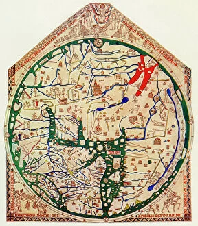
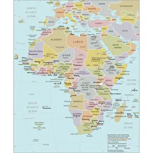
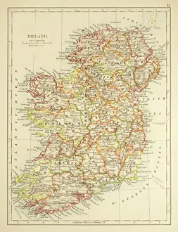
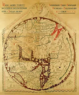
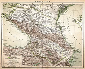
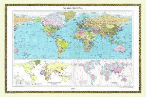
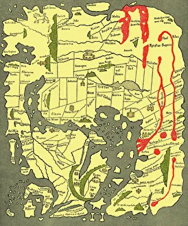
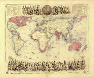
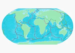
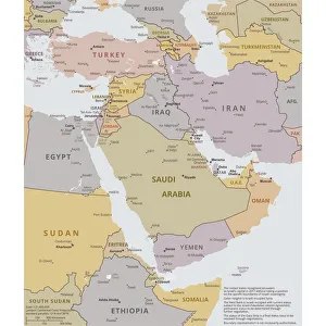
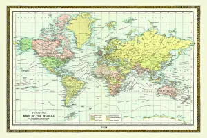
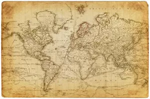
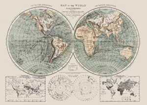
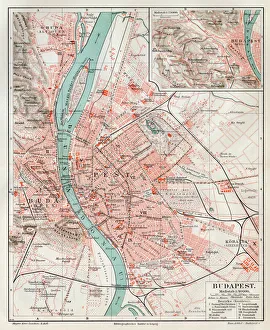
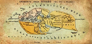
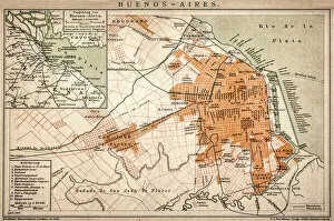
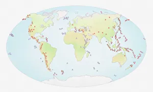
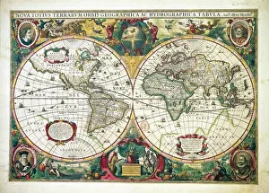
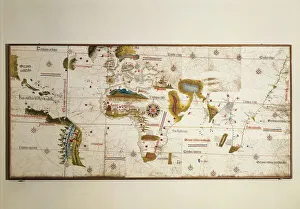
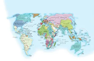
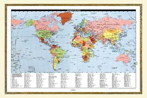
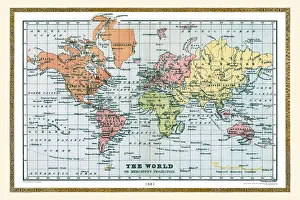
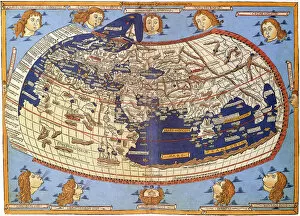
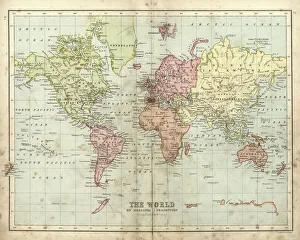
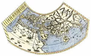
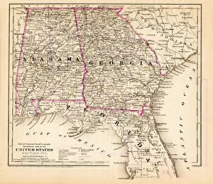
"Exploring the Rich Tapestry of Our World: From Ancient Vellum to Modern Tectonic Plates" Embark on a captivating journey through time and space with these fascinating glimpses into our world's diverse history. Delve into the depths of knowledge as you unravel the secrets held within each map, revealing stories of conquest, discovery, and cultural exchange. Discover Africa's political landscape in EXPL2A-00352 - an intricate tapestry showcasing the continent's ever-evolving borders and nations. Transport yourself back to 1897 Ireland with a vintage map that captures the essence of a bygone era. Unearth Hereford mappa mundi, a medieval masterpiece from c. 1290 meticulously crafted on vellum. Marvel at its intricate details depicting both known lands and mythical creatures, offering insight into ancient cartographic beliefs. Travel forward in time to witness how perceptions changed with an old map from 1980 or explore the vast reaches of the British Empire through a 19th-century world map. Immerse yourself in Anglo-Saxon culture with their unique interpretation of our planet during the 10th century. Witness historical events unfold before your eyes as you examine an old map from 1914, capturing geopolitical tensions prior to World War I. Dive deeper into local exploration with a Buenos Aires map or broaden your perspective by studying tectonic plates' boundaries etched across a global canvas. Finally, step back two centuries ago and marvel at how our understanding has evolved over time through an enchanting snapshot of the world in 1800. These maps are more than just geographical representations; they hold tales waiting to be discovered. Join us as we unlock their mysteries and celebrate humanity's insatiable curiosity for exploring every corner of this beautiful planet we call home.