Home > Arts > Artists > E > Alfred East
Alfreds Last War - Third Phase, 893. April to (?) June, (1935)
 June, (1935)")
![]()
Wall Art and Photo Gifts from Heritage Images
Alfreds Last War - Third Phase, 893. April to (?) June, (1935)
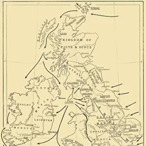
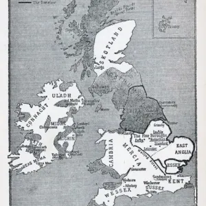
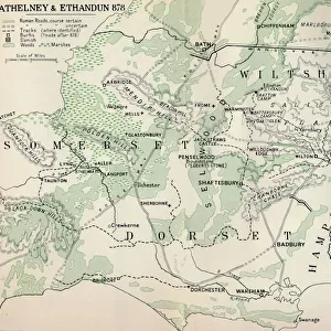
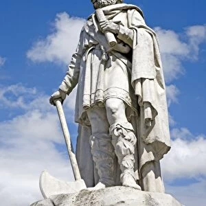
Alfreds Last War - Third Phase, 893. April to (?) June, (1935). Map of the south-east of England, showing Burhs (Old English fortifications) of the Anglo-Saxon King Alfred the Great, Danish forts, and significant sites during the period of Viking invasion. From A History of the Anglo-Saxons, Vol. II, by R. H. Hodgkin. [The Clarendon Press, Oxford, 1935]
Heritage Images features heritage image collections
Media ID 15466734
© The Print Collector / Heritage-Images
9th Century Aelfred Alfred I Alfred The Great Anglo Saxon Fort Forts Invasion King Alfred King Alfred The Great King Of Wessex Viking Danish
FEATURES IN THESE COLLECTIONS
> Arts
> Artists
> D
> Alfred
> Related Images
> Arts
> Artists
> E
> Alfred East
> Europe
> Denmark
> Related Images
> Europe
> United Kingdom
> England
> Maps
> Europe
> United Kingdom
> England
> Oxford
> Maps and Charts
> Related Images
Alfred's Last War - Third Phase, 893. April to (?) June, (1935)
EDITORS COMMENTS
. This print takes us back in time to the tumultuous period of Viking invasion in 9th century England. The map showcases the strategic fortifications known as Burhs, built by the Anglo-Saxon King Alfred the Great, along with Danish forts and other significant sites during this era of conflict. The monochrome aesthetic adds a sense of historical authenticity to this image from "A History of the Anglo-Saxons" by R. H. Hodgkin, published in 1935. It transports us to a time when kingdoms clashed and alliances were tested on the shores of Britain. As we study this map closely, we can almost feel ourselves standing alongside King Alfred himself, surveying his kingdom and plotting strategies against his Viking adversaries. The intricate details reveal not only geographical locations but also illustrate how these ancient fortifications played a crucial role in defending England's southern coast. This photograph serves as a powerful reminder of our rich heritage and reminds us that even amidst turmoil and war, great leaders like Alfred emerged to protect their people and preserve their way of life. It is an invaluable piece for history enthusiasts seeking insight into one of England's most iconic figures – King Alfred the Great – who shaped the destiny of an entire nation through courage and determination.
MADE IN AUSTRALIA
Safe Shipping with 30 Day Money Back Guarantee
FREE PERSONALISATION*
We are proud to offer a range of customisation features including Personalised Captions, Color Filters and Picture Zoom Tools
SECURE PAYMENTS
We happily accept a wide range of payment options so you can pay for the things you need in the way that is most convenient for you
* Options may vary by product and licensing agreement. Zoomed Pictures can be adjusted in the Cart.