Home > Africa > Democratic Republic of the Congo > Lakes > Lake Tanganyika
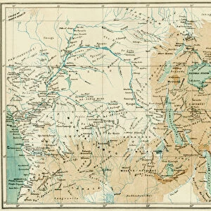
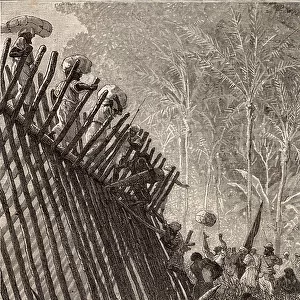
Map of a Portion of Africa, showing...Cameron's Route from the East to the West Coast...1876. Creator: Ernst Ravenstein

![]()
Wall Art and Photo Gifts from Heritage Images
Map of a Portion of Africa, showing...Cameron's Route from the East to the West Coast...1876. Creator: Ernst Ravenstein
Map of a Portion of Africa, showing Lieut. V.L. Cameron's Route from the East to the West Coast, 1876. A Map of the entire width of Africa, from the Indian Ocean to the Atlantic...It shows completely the African lake-region, one of the most remarkable geographical features in the world...Cameron has navigated one of these lakes, the Tanganyika, which Burton and Speke were the first to reach from the east coast, and the northern portions of it were navigated by Livingstone and Stanley. He has shown, moreover, that this Tanganyika discharges a river towards the west, and has thereby settled the vexed question of its connection with the Nile...Cameron has shown that the Tanganyika, and all the rivers which enter it, drain towards the west, into a river of mighty proportions; and there can be little doubt of this latter being the upper Congo [River]...'. From "Illustrated London News", 1876
Heritage Images features heritage image collections
Media ID 36374828
© The Print Collector/Heritage Images
Angola Cameron Verney Lovett Congo River Exploration Exploring Lake Tanganyika Africa Lakes Navigation River Congo Rivers Route Source Verney Lovett Cameron
FEATURES IN THESE COLLECTIONS
> Africa
> Angola
> Related Images
> Africa
> Democratic Republic of the Congo
> Lakes
> Lake Tanganyika
> Africa
> Democratic Republic of the Congo
> Lakes
> Related Images
> Africa
> Republic of the Congo
> Lakes
> Related Images
> Africa
> Tanzania
> Lakes
> Lake Tanganyika
> Africa
> Tanzania
> Lakes
> Related Images
> Africa
> Tanzania
> Related Images
EDITORS COMMENTS
This map, created by Ernst Ravenstein in 1876, showcases a portion of Africa, specifically highlighting the historic route taken by Lieutenant V.L. Cameron from the East to the West Coast. The map covers the entire width of Africa, from the Indian Ocean to the Atlantic, with a primary focus on the African lake region - a geographical feature of remarkable significance. The lake region is home to Lake Tanganyika, one of the largest and deepest lakes in the world. This lake holds a rich history, as it was first reached from the east coast by Burton and Speke, while its northern portions were explored by Livingstone and Stanley. Cameron's groundbreaking journey added to the collective knowledge of this magnificent body of water, revealing that it discharges a river towards the west. This discovery put an end to the long-standing debate regarding the connection between the Tanganyika and the Nile. Cameron's map further illustrates that the Tanganyika, along with all the rivers that flow into it, drain towards the west, leading into a mighty river of considerable proportions. There is little doubt that this mighty river is the upper Congo, which is a significant tributary that flows into the Atlantic Ocean. This map not only showcases the geographical marvels of Africa but also highlights the intrepid explorers who braved the unknown to expand our collective knowledge of the world.
MADE IN AUSTRALIA
Safe Shipping with 30 Day Money Back Guarantee
FREE PERSONALISATION*
We are proud to offer a range of customisation features including Personalised Captions, Color Filters and Picture Zoom Tools
SECURE PAYMENTS
We happily accept a wide range of payment options so you can pay for the things you need in the way that is most convenient for you
* Options may vary by product and licensing agreement. Zoomed Pictures can be adjusted in the Cart.