Home > Europe > France > Paris > Maps
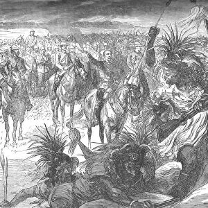
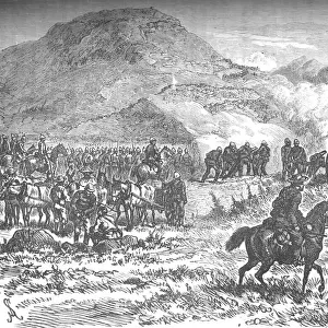
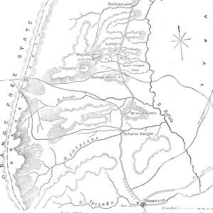
Sketch Map of Sekukunis Country, c1880

![]()
Wall Art and Photo Gifts from Heritage Images
Sketch Map of Sekukunis Country, c1880
Sketch Map of Sekukunis Country, c1880. From British Battles on Land and Sea, Vol. IV, by James Grant. [Cassell Petter & Galpin, London, Paris & Melbourne, c1880]
Heritage Images features heritage image collections
Media ID 14991919
© The Print Collector
Anglo Zulu Wars British Battles On Land And Sea Cassell Petter Galpin Grant Imperialism James Grant Military Operation Petter Galpin Plan South Africa South African Strategy Transvaal Zulu Wars Cassell
FEATURES IN THESE COLLECTIONS
> Africa
> Related Images
> Africa
> South Africa
> Maps
> Africa
> South Africa
> Related Images
> Africa
> South Africa
> Sekhukhune
> Arts
> Literature
> Europe
> France
> Canton
> Landes
> Europe
> France
> Paris
> Maps
> Historic
> Battles
> Related Images
> Maps and Charts
> Related Images
EDITORS COMMENTS
This print showcases a Sketch Map of Sekukuni's Country, dating back to the 19th century. The intricate details and monochrome aesthetic transport viewers to a time when British military strategy was unfolding in South Africa. This historical artifact is extracted from the renowned book "British Battles on Land and Sea" by James Grant, published by Cassell Petter & Galpin. The map serves as a visual guide to Sekukuni's Country, offering insights into its geographical features, indigenous settlements, and military operations during that era. It provides an invaluable glimpse into the complex dynamics between Britain and South African natives during this period of imperialism. With its hand-drawn sketches and meticulous attention to detail, this print not only captures the essence of 19th-century cartography but also highlights the significance of literature in documenting historical events. As we explore this artwork further, we are transported back in time to witness the strategic planning undertaken by British forces in their encounters with Sekukuni's people. Through this image, we gain a deeper understanding of how colonial powers sought control over territories like Transvaal while engaging with local communities such as those led by Chief Sekhukhune. This print stands as a testament to both the artistic skill involved in creating it and its importance as a record of past conflicts shaping South Africa's history.
MADE IN AUSTRALIA
Safe Shipping with 30 Day Money Back Guarantee
FREE PERSONALISATION*
We are proud to offer a range of customisation features including Personalised Captions, Color Filters and Picture Zoom Tools
SECURE PAYMENTS
We happily accept a wide range of payment options so you can pay for the things you need in the way that is most convenient for you
* Options may vary by product and licensing agreement. Zoomed Pictures can be adjusted in the Cart.