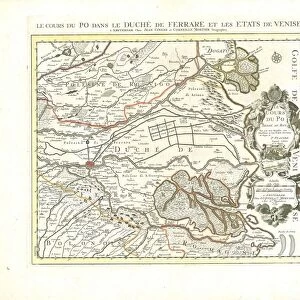
Map Carte particuliere du Bressan faisant partie des etats dela Repu

![]()
Wall Art and Photo Gifts from Liszt Collection
Map Carte particuliere du Bressan faisant partie des etats dela Repu
Map, Carte particuliere du Bressan faisant partie des etats dela Republique de Venise, Guillaume Sanson (-1703), Copperplate print
Liszt Collection of nineteenth-century engravings and images to browse and enjoy
Media ID 19586585
© Artokoloro
1703 Copperplate Print Guillaume Sanson
EDITORS COMMENTS
This copperplate print, titled "Map Carte particuliere du Bressan faisant partie des etats dela Republique de Venise" is a true masterpiece from the Liszt Collection. Created by the talented cartographer Guillaume Sanson in 1703, this map offers a unique glimpse into the historical region of Bresse within the Republic of Venice. The intricate details and precise craftsmanship showcased in this print are truly remarkable. Every line and contour has been meticulously engraved onto the copperplate, resulting in an exquisite representation of the land. The delicate shading adds depth to the map, allowing viewers to immerse themselves in its beauty. As we gaze upon this ancient cartographic gem, we can't help but be transported back in time. It serves as a window into an era when maps were not only practical tools for navigation but also works of art that conveyed political boundaries and territorial divisions. The Map Carte particuliere du Bressan provides us with valuable insights into how our world was perceived centuries ago. It reminds us of the importance placed on accurate geographical knowledge during that period and highlights how far cartography has evolved since then. Whether you are a history enthusiast or simply appreciate fine art, this copperplate print is sure to captivate your imagination. Display it proudly on your wall or use it as a conversation starter; either way, it will undoubtedly add elegance and sophistication to any space.
MADE IN AUSTRALIA
Safe Shipping with 30 Day Money Back Guarantee
FREE PERSONALISATION*
We are proud to offer a range of customisation features including Personalised Captions, Color Filters and Picture Zoom Tools
SECURE PAYMENTS
We happily accept a wide range of payment options so you can pay for the things you need in the way that is most convenient for you
* Options may vary by product and licensing agreement. Zoomed Pictures can be adjusted in the Cart.