Home > Europe > United Kingdom > England > Birmingham > Area > Yardley Wood
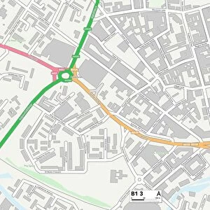
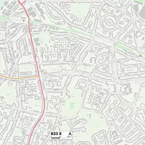
Birmingham B28 0 Map

![]()
Wall Art and Photo Gifts from Map Marketing
Birmingham B28 0 Map
Postcode Sector Map of Birmingham B28 0
Media ID 19965373
Birmingham Glover Close Goodman Close Grosvenor Square Harewood Close Highfield Close Highfield Road Hilton Avenue Kedleston Road Longfield Close Millside Nairn Close Oak Tree Gardens Painswick Road Paradise Lane Petersfield Road Primrose Lane Priory Gardens Priory Road Riley Road Riversdale Road Riverside Crescent Robin Hood Lane Romney Close Sandgate Road Sherwood Close Sherwood Road Slade Lane Southam Road Woodvale Road The Robins
FEATURES IN THESE COLLECTIONS
> Map Marketing
> Postcode Sector Maps
> B - Birmingham
> Animals
> Mammals
> Muridae
> Peters Mouse
> Europe
> United Kingdom
> England
> Birmingham
> Area
> Hall Green
> Europe
> United Kingdom
> England
> Birmingham
> Area
> Yardley Wood
> Europe
> United Kingdom
> England
> Birmingham
> Area
> Yardley
> Europe
> United Kingdom
> Scotland
> Highlands
> Nairn
> Maps and Charts
> Related Images
MADE IN AUSTRALIA
Safe Shipping with 30 Day Money Back Guarantee
FREE PERSONALISATION*
We are proud to offer a range of customisation features including Personalised Captions, Color Filters and Picture Zoom Tools
SECURE PAYMENTS
We happily accept a wide range of payment options so you can pay for the things you need in the way that is most convenient for you
* Options may vary by product and licensing agreement. Zoomed Pictures can be adjusted in the Cart.