Home > Europe > United Kingdom > England > London > Sights > Lee Valley
St Edmundsbury CB9 8 Map

![]()
Wall Art and Photo Gifts from Map Marketing
St Edmundsbury CB9 8 Map
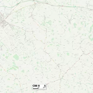
Postcode Sector Map of St Edmundsbury CB9 8
Media ID 19967412
Beaumont Court Buckingham Road Clarendon Road Clements Close Connaught Road Cornwallis Road Croft Lane Eden Road Elmhurst Close Gloucester Road Greenfields Way Hamlet Road Harrow Road High Street Holbrook Road Homefield Road Manor Farm Close Market Hill Mill Hill Mill Road Mount Road Nayland Road Norton Road Orchard Close Orford Road Priory Avenue Quakers Lane Recreation Road St Edmundsbury Thompson Close Tudor Close York Road Clements Clements Lane Haverhill Leather Lane
FEATURES IN THESE COLLECTIONS
> Map Marketing
> Postcode Sector Maps
> CB - Cambridge
> Animals
> Fishes
> W
> Whiting
> Arts
> Portraits
> Pop art gallery
> Street art portraits
> Europe
> United Kingdom
> England
> London
> Boroughs
> Harrow
> Europe
> United Kingdom
> England
> London
> Sights
> Holland Park
> Europe
> United Kingdom
> England
> London
> Sights
> Lee Valley
> Maps and Charts
> Related Images
MADE IN AUSTRALIA
Safe Shipping with 30 Day Money Back Guarantee
FREE PERSONALISATION*
We are proud to offer a range of customisation features including Personalised Captions, Color Filters and Picture Zoom Tools
SECURE PAYMENTS
We happily accept a wide range of payment options so you can pay for the things you need in the way that is most convenient for you
* Options may vary by product and licensing agreement. Zoomed Pictures can be adjusted in the Cart.