Home > Europe > United Kingdom > Wales > Ceredigion > Tregaron
Cardiff CF5 4 Map

![]()
Wall Art and Photo Gifts from Map Marketing
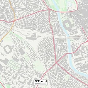
Cardiff CF5 4 Map
Postcode Sector Map of Cardiff CF5 4
Media ID 19967874
Addison Crescent Archer Road Cardiff Celandine Road Crossways Road Forge Place Foxglove Close Furness Close Glyndwr Road Goodwood Close Gough Road Grand Avenue Heol Y Felin Highbury Road Howell Road Jackson Road Kenwood Road Macdonald Road Meyrick Road Mill Place Mill Road Moore Close Moore Road Mostyn Road Parker Road Red House Close Red House Road Sevenoaks Road Spinney Close St Davids Crescent Stanway Road Station Terrace Stirling Road Wheatley Road Wilson Place Wilson Road Yarrow Close Highbury Place The Sanctuary
FEATURES IN THESE COLLECTIONS
> Map Marketing
> Postcode Sector Maps
> CF - Cardiff
> Animals
> Fishes
> S
> Snook
> Animals
> Mammals
> Muridae
> House Mouse
> Arts
> Artists
> W
> Wilson Wilson
> Europe
> United Kingdom
> Scotland
> Stirlingshire
> Stirling
> Europe
> United Kingdom
> Wales
> Ceredigion
> Tregaron
> Europe
> United Kingdom
> Wales
> Gwent
> Related Images
> Europe
> United Kingdom
> Wales
> Pembrokeshire
> St Davids
> Europe
> United Kingdom
> Wales
> South Glamorgan
> Cardiff
> Maps and Charts
> Related Images
MADE IN AUSTRALIA
Safe Shipping with 30 Day Money Back Guarantee
FREE PERSONALISATION*
We are proud to offer a range of customisation features including Personalised Captions, Color Filters and Picture Zoom Tools
SECURE PAYMENTS
We happily accept a wide range of payment options so you can pay for the things you need in the way that is most convenient for you
* Options may vary by product and licensing agreement. Zoomed Pictures can be adjusted in the Cart.