Home > Architecture > Towers > Churches
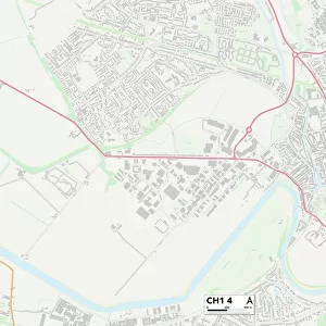
Cheshire West and Chester CH1 4 Map

![]()
Wall Art and Photo Gifts from Map Marketing
Cheshire West and Chester CH1 4 Map
Postcode Sector Map of Cheshire West and Chester CH1 4
Media ID 19967038
A548 Archers Way Arthur Street Cambrian Road Canal Street Catherine Street Chantry Court Charlotte Street Chelford Close Cheshire West And Chester Deanery Close Denbigh Street Enderby Road Garden Court Garden Lane Gladstone Avenue Gladstone Road Goodwood Close Granville Road Haydock Close Jesmond Road Kempton Close Leonard Street Lorne Street Moss Bank Newton Close Orchard Street Parkgate Road Queensgate Salisbury Street Sedgefield Road South Bank South View Road Sovereign Way Stadium Way Sydney Road Tower Road Vernon Road Walpole Street West Bank Wetherby Close Woodlands Avenue Bouverie Street Raymond Street
FEATURES IN THESE COLLECTIONS
> Map Marketing
> Postcode Sector Maps
> CH - Chester
> Architecture
> Towers
> Churches
> Arts
> Portraits
> Pop art gallery
> Street art portraits
> Europe
> United Kingdom
> England
> Cheshire
> Chelford
> Europe
> United Kingdom
> England
> Cheshire
> Chester
> Europe
> United Kingdom
> England
> Cheshire
> Hartford
> Europe
> United Kingdom
> England
> Cheshire
> Knutsford
> Europe
> United Kingdom
> England
> Cheshire
> Newton
> Europe
> United Kingdom
> England
> Cheshire
> Related Images
> Europe
> United Kingdom
> England
> Cheshire
> Winsford
> Europe
> United Kingdom
> Wales
> West Glamorgan
> Port Talbot
MADE IN AUSTRALIA
Safe Shipping with 30 Day Money Back Guarantee
FREE PERSONALISATION*
We are proud to offer a range of customisation features including Personalised Captions, Color Filters and Picture Zoom Tools
SECURE PAYMENTS
We happily accept a wide range of payment options so you can pay for the things you need in the way that is most convenient for you
* Options may vary by product and licensing agreement. Zoomed Pictures can be adjusted in the Cart.