Home > Europe > United Kingdom > England > London > Boroughs > Newham
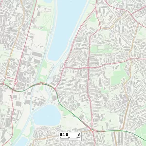
Newham E15 3 Map

![]()
Wall Art and Photo Gifts from Map Marketing
Newham E15 3 Map
Postcode Sector Map of Newham E15 3
Media ID 19969760
Abbey Road Bridge Road Canning Road Celandine Way Chaplin Road Church Street Corporation Street Dell Close Durban Road East Road Eastbourne Road Gainsborough Road Hamilton Road Harcourt Road Holbrook Road Holland Road John Street Kay Street Manor Road Marcus Street Memorial Avenue Milner Road Morley Road Napier Road Newham Park Grove Park Road Pond Road Portway Ranelagh Road Richardson Road Springfield Road Stephens Road Teasel Way West Road Willis Road West Ham
FEATURES IN THESE COLLECTIONS
> Map Marketing
> Postcode Sector Maps
> E - London E
> Animals
> Birds
> Passerines
> Crows And Jays
> Related Images
> Arts
> Artists
> K
> John Kay
> Arts
> Portraits
> Pop art gallery
> Street art portraits
> Europe
> United Kingdom
> England
> London
> Boroughs
> Newham
> Europe
> United Kingdom
> England
> London
> Sights
> Holland Park
> Europe
> United Kingdom
> Scotland
> Strathclyde
> Hamilton
> Maps and Charts
> Related Images
> North America
> Saint Lucia
> Maps
MADE IN AUSTRALIA
Safe Shipping with 30 Day Money Back Guarantee
FREE PERSONALISATION*
We are proud to offer a range of customisation features including Personalised Captions, Color Filters and Picture Zoom Tools
SECURE PAYMENTS
We happily accept a wide range of payment options so you can pay for the things you need in the way that is most convenient for you
* Options may vary by product and licensing agreement. Zoomed Pictures can be adjusted in the Cart.