Home > Europe > United Kingdom > Scotland > Highlands > Wick
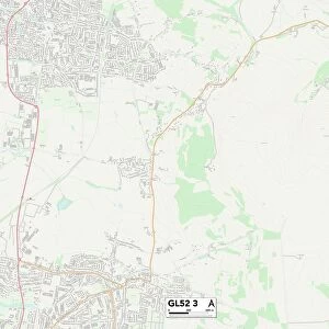
Cotswold GL7 6 Map

![]()
Wall Art and Photo Gifts from Map Marketing
Cotswold GL7 6 Map
Postcode Sector Map of Cotswold GL7 6
Media ID 19970403
Ashton Road Chapel Close Church Avenue Church Lane Church Road Clarks Lane Cotswold Elizabeth Way Elm View Glebe Lane Hambledon Close High Street Jubilee Gardens Limes Road May Tree Close Meadow Way Mill Lane Old Vicarage Lane Orchard Close Park Way Pound Close River Way School Road St Peters Close Station Road Stroud Road The Close The Common The Glebe The Oaks Thompson Road Water Lane West Lane Windmill Road Woodlands Coates Kemble Siddington Somerford Keynes Tarlton The Secret Garden
FEATURES IN THESE COLLECTIONS
> Map Marketing
> Postcode Sector Maps
> GL - Gloucester
> Animals
> Mammals
> Bovidae
> Ox
> Animals
> Mammals
> Muridae
> Peters Mouse
> Animals
> Mammals
> Muridae
> Water Mouse
> Arts
> Artists
> O
> Elizabeth Olds
> Arts
> Landscape paintings
> Waterfall and river artworks
> River artworks
> Arts
> Portraits
> Pop art gallery
> Street art portraits
> Europe
> United Kingdom
> England
> London
> River Thames
> Europe
> United Kingdom
> Scotland
> Highlands
> Wick
> Maps and Charts
> Related Images
MADE IN AUSTRALIA
Safe Shipping with 30 Day Money Back Guarantee
FREE PERSONALISATION*
We are proud to offer a range of customisation features including Personalised Captions, Color Filters and Picture Zoom Tools
SECURE PAYMENTS
We happily accept a wide range of payment options so you can pay for the things you need in the way that is most convenient for you
* Options may vary by product and licensing agreement. Zoomed Pictures can be adjusted in the Cart.