Home > Europe > United Kingdom > England > Hampshire > Denvilles
Hampshire PO6 1 Map

![]()
Wall Art and Photo Gifts from Map Marketing
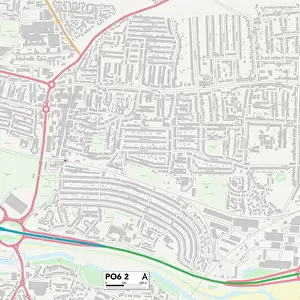
Hampshire PO6 1 Map
Postcode Sector Map of Hampshire PO6 1
Media ID 19979560
Acorn Close Ainsdale Road Augustine Road Birkdale Avenue Blake Road Burnham Road Central Road Copper Beech Drive Drayton Drayton Lane First Avenue Grant Road Grove Road Hampshire Hardy Road Havant Road Highlands Road Hilltop Crescent Hirst Road Homefield Road Hoylake Road Jackson Close Kestrel Place Laburnum Avenue Marsh Close Rectory Avenue Scholars Walk Sea View Road Second Avenue Shearwater Drive Solent Road South Road St Andrews Road Station Road The Fairways The Saltings Uplands Road Wainwright Close Walton Road Waterworks Road Waverley Road Woodfield Avenue Zetland Road
FEATURES IN THESE COLLECTIONS
> Map Marketing
> Postcode Sector Maps
> PO - Portsmouth
> Animals
> Birds
> Seabirds
> Shearwaters
> Related Images
> Europe
> United Kingdom
> England
> Hampshire
> Ashley
> Europe
> United Kingdom
> England
> Hampshire
> Beech
> Europe
> United Kingdom
> England
> Hampshire
> Denvilles
> Europe
> United Kingdom
> England
> Hampshire
> East End
> Europe
> United Kingdom
> England
> Hampshire
> Havant
> Europe
> United Kingdom
> England
> Hampshire
> Related Images
> Europe
> United Kingdom
> Scotland
> Fife
> St Andrews
> Europe
> United Kingdom
> Scotland
> Highlands
> Related Images
> Europe
> United Kingdom
> Scotland
> Strathclyde
> Troon
MADE IN AUSTRALIA
Safe Shipping with 30 Day Money Back Guarantee
FREE PERSONALISATION*
We are proud to offer a range of customisation features including Personalised Captions, Color Filters and Picture Zoom Tools
SECURE PAYMENTS
We happily accept a wide range of payment options so you can pay for the things you need in the way that is most convenient for you
* Options may vary by product and licensing agreement. Zoomed Pictures can be adjusted in the Cart.