Home > Europe > United Kingdom > Scotland > Aberdeenshire > Maud
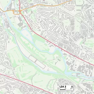
Leeds LS21 2 Map

![]()
Wall Art and Photo Gifts from Map Marketing
Leeds LS21 2 Map
Postcode Sector Map of Leeds LS21 2
Media ID 19973769
Back Lane Belmont Avenue Church Hill Church Lane Cinder Lane Clifton Clifton Lane Coach Lane Cooper Lane Croft Avenue Dark Lane Grange View Green Lane Hall Lane Leeds Low Lane Mellor Close Middleton Court Moor Lane Moorside Lane New Lane North Lane Riverside Avenue Riverside Close Riverside Crescent Riverside Drive Riverside Park Skipton Road St Davids Road St Martins Avenue St Richards Road The Crescent The Crossways The Green The Oval Top Lane West Lane Weston Weston Crescent Weston Drive Weston Lane Wharfedale Drive Wilkinson Way Lindley Newall
FEATURES IN THESE COLLECTIONS
> Map Marketing
> Postcode Sector Maps
> LS - Leeds
> Animals
> Mammals
> Muridae
> House Mouse
> Arts
> Artists
> B
> David Beck
> Arts
> Artists
> M
> David Martin
> Arts
> Artists
> W
> Henry Wilkinson
> Europe
> United Kingdom
> Scotland
> Aberdeenshire
> Maud
> Europe
> United Kingdom
> Wales
> Pembrokeshire
> St Davids
> Maps and Charts
> Related Images
> North America
> Saint Martin
> Maps
MADE IN AUSTRALIA
Safe Shipping with 30 Day Money Back Guarantee
FREE PERSONALISATION*
We are proud to offer a range of customisation features including Personalised Captions, Color Filters and Picture Zoom Tools
SECURE PAYMENTS
We happily accept a wide range of payment options so you can pay for the things you need in the way that is most convenient for you
* Options may vary by product and licensing agreement. Zoomed Pictures can be adjusted in the Cart.