Home > Europe > United Kingdom > England > Herefordshire > Ledbury > Robert Browning
Mansfield NG18 5 Map

![]()
Wall Art and Photo Gifts from Map Marketing
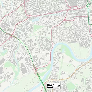
Mansfield NG18 5 Map
Postcode Sector Map of Mansfield NG18 5
Media ID 19974428
Browning Street Cambridge Street Cape Street Castle Street Chaucer Street Cherry Grove Cherry Lane Davey Close Davey Road Derby Road Fuller Close Garth Road Goldsmith Street Grange Avenue Hamilton Way Harrington Street Harrison Road Heather Close Herbert Street Hermitage Avenue Hermitage Lane Hermitage Way Highfield Way Holden Street King Edward Avenue Kings Mill Lane Kirkland Avenue Langham Place Lindsay Close Mansfield Matlock Avenue Mayflower Court Mill Court Milton Street Moor Lane Moor Street Nottingham Road Oakdale Road Paddock Close Princes Street Quarry Lane Spencer Street Spinners Close Sutton Road The Knoll Victoria Street Ward Place Washington Drive Western Avenue Western Close York Street Sylvester Street
FEATURES IN THESE COLLECTIONS
> Map Marketing
> Postcode Sector Maps
> NG - Nottingham
> Animals
> Mammals
> Muridae
> Western Mouse
> Animals
> Reptiles
> Snakes
> King Brown
> Arts
> Artists
> H
> Robert Hills
> Arts
> Portraits
> Pop art gallery
> Street art portraits
> Europe
> United Kingdom
> England
> Herefordshire
> Ledbury
> Robert Browning
> Europe
> United Kingdom
> England
> London
> Sights
> Victoria Park
> Europe
> United Kingdom
> Scotland
> Aberdeenshire
> Huntly
> Europe
> United Kingdom
> Scotland
> Strathclyde
> Hamilton
> Maps and Charts
> Related Images
MADE IN AUSTRALIA
Safe Shipping with 30 Day Money Back Guarantee
FREE PERSONALISATION*
We are proud to offer a range of customisation features including Personalised Captions, Color Filters and Picture Zoom Tools
SECURE PAYMENTS
We happily accept a wide range of payment options so you can pay for the things you need in the way that is most convenient for you
* Options may vary by product and licensing agreement. Zoomed Pictures can be adjusted in the Cart.