Home > Europe > United Kingdom > England > London > Boroughs > Barnet
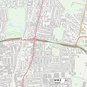
Barnet N12 8 Map

![]()
Wall Art and Photo Gifts from Map Marketing
Barnet N12 8 Map
Postcode Sector Map of Barnet N12 8
Media ID 19975645
Albert Street Ashbourne Close Avenue Road Avondale Avenue Barnet Coleridge Road Derby Avenue Gainsborough Road Grange Avenue Grangeway Green Bank Hall Street Highwood Avenue Holden Avenue Hughes Close Limes Avenue Lodge Lane Netherfield Road Percy Road St Andrews Close The Oaks Woodside Avenue Woodside Grove
FEATURES IN THESE COLLECTIONS
> Map Marketing
> Postcode Sector Maps
> N - London N
> Animals
> Mammals
> Squirrel
> Arts
> Portraits
> Pop art gallery
> Street art portraits
> Europe
> United Kingdom
> England
> London
> Boroughs
> Barnet
> Europe
> United Kingdom
> Scotland
> Fife
> St Andrews
> Maps and Charts
> Related Images
MADE IN AUSTRALIA
Safe Shipping with 30 Day Money Back Guarantee
FREE PERSONALISATION*
We are proud to offer a range of customisation features including Personalised Captions, Color Filters and Picture Zoom Tools
SECURE PAYMENTS
We happily accept a wide range of payment options so you can pay for the things you need in the way that is most convenient for you
* Options may vary by product and licensing agreement. Zoomed Pictures can be adjusted in the Cart.