Home > Europe > United Kingdom > Northern Ireland > County Down > Newcastle
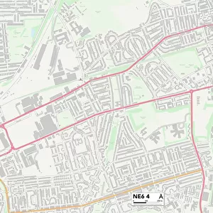
Newcastle NE6 2 Map

![]()
Wall Art and Photo Gifts from Map Marketing
Newcastle NE6 2 Map
Postcode Sector Map of Newcastle NE6 2
Media ID 19974534
Ada Street Alfred Street Algernon Road Allendale Road Avondale Road Benson Road Beresford Gardens Brook Street Canterbury Street Chatsworth Gardens Clifford Road Clydesdale Road Commercial Road Cresswell Street Dalton Street Denmark Street Depot Road Emily Street Grace Street Grasmere Avenue Harriet Street Jane Street Kendal Street Kingston Avenue Kirk Street Lawson Close Leicester Street Lichfield Avenue Mason Street Millers Road Morton Street Newcastle Priory Place Raby Street Robinson Street Scarborough Road Shields Road Springwell Avenue St Marks Close St Marks Street St Michaels Mount St Peters Road Staines Road Troutbeck Avenue Tynemouth Road Union Road Walker Road Wilton Avenue
FEATURES IN THESE COLLECTIONS
> Map Marketing
> Postcode Sector Maps
> NE - Newcastle upon Tyne
> Animals
> Mammals
> Muridae
> Peters Mouse
> Arts
> Artists
> D
> Alfred
> Related Images
> Arts
> Portraits
> Pop art gallery
> Street art portraits
> Europe
> Denmark
> Related Images
> Europe
> United Kingdom
> Northern Ireland
> County Down
> Newcastle
> Maps and Charts
> Related Images
MADE IN AUSTRALIA
Safe Shipping with 30 Day Money Back Guarantee
FREE PERSONALISATION*
We are proud to offer a range of customisation features including Personalised Captions, Color Filters and Picture Zoom Tools
SECURE PAYMENTS
We happily accept a wide range of payment options so you can pay for the things you need in the way that is most convenient for you
* Options may vary by product and licensing agreement. Zoomed Pictures can be adjusted in the Cart.