Home > Europe > United Kingdom > England > Devon > Ash
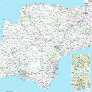
West Devon PL20 6 Map

![]()
Wall Art and Photo Gifts from Map Marketing
West Devon PL20 6 Map
Postcode Sector Map of West Devon PL20 6
Media ID 19978292
Abbots Way Ash Close Barrack Road Beech Crescent Beechfield Avenue Black Lane Boundary Road Church Hill Church View Grange Road Gratton Lane Green Lane Hazel Grove Holt Close Lake Lake Lane Langton Road Manor Farm Manor Park Moor Crescent Moorland Close Myrtle Close North Road Station Road Tavistock Road The Green Woodlands Woodville Avenue Postbridge Princetown Two Bridges West Devon Yelverton
FEATURES IN THESE COLLECTIONS
> Map Marketing
> Postcode Sector Maps
> PL - Plymouth
> Europe
> United Kingdom
> England
> Devon
> Ash
> Europe
> United Kingdom
> England
> Devon
> Bellever
> Europe
> United Kingdom
> England
> Devon
> Church Green
> Europe
> United Kingdom
> England
> Devon
> Hexworthy
> Europe
> United Kingdom
> England
> Devon
> Ivybridge
> Europe
> United Kingdom
> England
> Devon
> Meavy
> Europe
> United Kingdom
> England
> Devon
> Merrivale
> Europe
> United Kingdom
> England
> Devon
> Milton Abbot
> Europe
> United Kingdom
> England
> Devon
> Plymouth
> Europe
> United Kingdom
> England
> Devon
> Postbridge
MADE IN AUSTRALIA
Safe Shipping with 30 Day Money Back Guarantee
FREE PERSONALISATION*
We are proud to offer a range of customisation features including Personalised Captions, Color Filters and Picture Zoom Tools
SECURE PAYMENTS
We happily accept a wide range of payment options so you can pay for the things you need in the way that is most convenient for you
* Options may vary by product and licensing agreement. Zoomed Pictures can be adjusted in the Cart.