Home > Europe > United Kingdom > England > Isle of Wight > Chale
Isle of Wight PO38 2 Map

![]()
Wall Art and Photo Gifts from Map Marketing
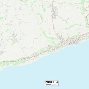
Isle of Wight PO38 2 Map
Postcode Sector Map of Isle of Wight PO38 2
Media ID 19978203
Bury Lane Church Place Church Street High Street Hills Lane Howard Close Isle Of Wight Ivy Close Kingston Meadow Close Military Road Millers Lane Newport Road Priory Walk Rectory Lane Rectory Road Sandrock Road School Lane St Catherines Road The Glen The Greenway The Orchard The Terrace Town End Town Lane Ventnor Road Whitwell Whitwell Road Blackgang Chale Niton Pyle Southdown
FEATURES IN THESE COLLECTIONS
> Map Marketing
> Postcode Sector Maps
> PO - Portsmouth
> Animals
> Mammals
> Muridae
> House Mouse
> Arts
> Artists
> P
> Howard Pyle
> Arts
> Portraits
> Pop art gallery
> Street art portraits
> Europe
> United Kingdom
> England
> Isle of Wight
> Blackgang
> Europe
> United Kingdom
> England
> Isle of Wight
> Chale
> Europe
> United Kingdom
> England
> Isle of Wight
> Newport
> Europe
> United Kingdom
> England
> Isle of Wight
> Niton
> Europe
> United Kingdom
> England
> Isle of Wight
> Ventnor
> Europe
> United Kingdom
> England
> Isle of Wight
> Whitwell
> Europe
> United Kingdom
> Wales
> Gwent
> Newport
MADE IN AUSTRALIA
Safe Shipping with 30 Day Money Back Guarantee
FREE PERSONALISATION*
We are proud to offer a range of customisation features including Personalised Captions, Color Filters and Picture Zoom Tools
SECURE PAYMENTS
We happily accept a wide range of payment options so you can pay for the things you need in the way that is most convenient for you
* Options may vary by product and licensing agreement. Zoomed Pictures can be adjusted in the Cart.