Home > Arts > Artists > B > Charles Brooking
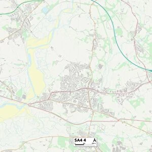
Neath Port Talbot SA10 6 Map

![]()
Wall Art and Photo Gifts from Map Marketing
Neath Port Talbot SA10 6 Map
Postcode Sector Map of Neath Port Talbot SA10 6
Media ID 19977742
Bosworth Road Brook Street Bryngwyn Burrows Road Castle Street Charles Street Christopher Road Compton Avenue Evelyn Road Francis Street Graham Terrace Graig Road Grove Lane Heol Yr Ysgol High Street Highland Close Hill View Jubilee Crescent Neath Port Talbot New Road Park Avenue Park Crescent Park Drive Park Street Pen Y Bryn Picton Road Queens Road Springfield Road St Margarets Avenue Stanley Road Station Road Tabernacle Street Talbot Road The Greenway The Highlands Villiers Road Wern Road Winifred Road Woodland Close Woodland Road
FEATURES IN THESE COLLECTIONS
> Map Marketing
> Postcode Sector Maps
> SA - Swansea
> Arts
> Artists
> B
> Charles Brooking
> Arts
> Artists
> C
> Charles Compton
> Arts
> Artists
> G
> Charles Graham
> Arts
> Artists
> G
> Charles Green
> Arts
> Artists
> P
> Francis Place
> Arts
> Portraits
> Pop art gallery
> Street art portraits
> Europe
> United Kingdom
> Scotland
> Highlands
> Related Images
> Europe
> United Kingdom
> Wales
> Glamorgan
> Europe
> United Kingdom
> Wales
> West Glamorgan
> Neath
> Europe
> United Kingdom
> Wales
> West Glamorgan
> Port Talbot
MADE IN AUSTRALIA
Safe Shipping with 30 Day Money Back Guarantee
FREE PERSONALISATION*
We are proud to offer a range of customisation features including Personalised Captions, Color Filters and Picture Zoom Tools
SECURE PAYMENTS
We happily accept a wide range of payment options so you can pay for the things you need in the way that is most convenient for you
* Options may vary by product and licensing agreement. Zoomed Pictures can be adjusted in the Cart.