Home > Europe > United Kingdom > England > London > Sights > Osterley Park
Swindon SN25 1 Map

![]()
Wall Art and Photo Gifts from Map Marketing
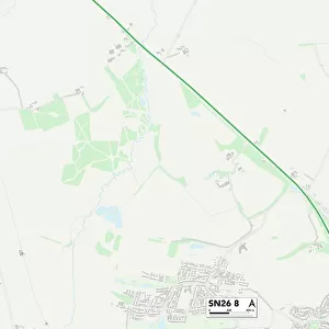
Swindon SN25 1 Map
Postcode Sector Map of Swindon SN25 1
Media ID 19981122
Ashdown Way Betony Close Bryant Road Churchfield Dewberry Close Dickenson Road Exmoor Close Foxglove Road Friday Street Furlong Close Galloway Road Giles Road Glenmore Road Hardy Close Harebell Close Hatfield Close Helmsdale High Street Honeysuckle Close Jasmine Close Marjoram Close Meadowsweet Close Paddock Close Primrose Close Queen Elizabeth Drive Rosemary Close Sage Close Shanklin Road Snowdrop Close Speedwell Close Stevenson Road Swindon The Boulevard The Brow Ventnor Close Westfield Way Wheatlands Willowherb Close Winterbourne Road Cranborne Chase Maida Vale
FEATURES IN THESE COLLECTIONS
> Map Marketing
> Postcode Sector Maps
> SN - Swindon
> Arts
> Portraits
> Pop art gallery
> Street art portraits
> Europe
> United Kingdom
> England
> London
> Sights
> Osterley Park
> Europe
> United Kingdom
> Scotland
> Dumfries and Galloway
> Related Images
> Europe
> United Kingdom
> Scotland
> Highlands
> Wick
> Maps and Charts
> Related Images
> North America
> United States of America
> New York
> New York
> Sights
> Bryant Park
MADE IN AUSTRALIA
Safe Shipping with 30 Day Money Back Guarantee
FREE PERSONALISATION*
We are proud to offer a range of customisation features including Personalised Captions, Color Filters and Picture Zoom Tools
SECURE PAYMENTS
We happily accept a wide range of payment options so you can pay for the things you need in the way that is most convenient for you
* Options may vary by product and licensing agreement. Zoomed Pictures can be adjusted in the Cart.