Home > Europe > United Kingdom > England > London > Towns > Bush Hill Park
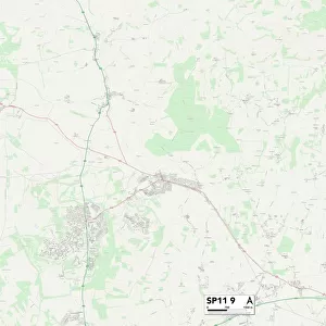
Test Valley SP11 0 Map

![]()
Wall Art and Photo Gifts from Map Marketing
Test Valley SP11 0 Map
Postcode Sector Map of Test Valley SP11 0
Media ID 19978744
Andover Road Back Lane Beech Close Bowers Lane Chapel Lane Church Lane Church Street Clarkes Lane Crabtree Lane Fairview Road Green Lane Hall Lane Hatch Lane Holt Lane Horseshoe Lane Lodge Drive London Lane Netherton Rectory Place School Close Short Lane Stoke Stoke Hill Stoke Lane Stoke Road Test Valley The Avenue The Close The Crescent The Dell The Grove Upton Windmill Lane Woodside
FEATURES IN THESE COLLECTIONS
> Map Marketing
> Postcode Sector Maps
> SP - Salisbury
> Arts
> Portraits
> Pop art gallery
> Street art portraits
> Europe
> United Kingdom
> England
> London
> Sights
> Green Park
> Europe
> United Kingdom
> England
> London
> Towns
> Bush Hill Park
> Europe
> United Kingdom
> England
> London
> Towns
> Grove Park
> Europe
> United Kingdom
> England
> London
> Towns
> Newbury Park
> Europe
> United Kingdom
> England
> London
> Towns
> Woodside Park
> Europe
> United Kingdom
> England
> London
> Towns
> Woodside
> Maps and Charts
> Related Images
MADE IN AUSTRALIA
Safe Shipping with 30 Day Money Back Guarantee
FREE PERSONALISATION*
We are proud to offer a range of customisation features including Personalised Captions, Color Filters and Picture Zoom Tools
SECURE PAYMENTS
We happily accept a wide range of payment options so you can pay for the things you need in the way that is most convenient for you
* Options may vary by product and licensing agreement. Zoomed Pictures can be adjusted in the Cart.