Home > Europe > United Kingdom > England > London > Boroughs > Lambeth
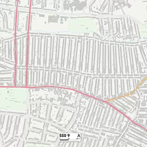
Southend-on-Sea SS9 5 Map

Only Available in the UK and Ireland
![]()
Wall Art and Photo Gifts from Map Marketing
Southend-on-Sea SS9 5 Map
Postcode Sector Map of Southend-on-Sea SS9 5
Media ID 19978660
Belgrave Close Belgrave Road Boleyn Close Bosworth Road Boundary Road Bramble Close Bramble Road Brookfields Brooklands Avenue Brunel Road Eastwood Eastwood Road Epping Close Fairfield Crescent Fairfield Gardens Fairfield Road Faraday Road Glenwood Avenue Gravel Road Green Lane Grove Hill Hartland Close Hillside Road Howards Way Hudson Road Lambeth Road Langley Close Orchard Grove Paddock Close Park Avenue Pinewood Avenue Rayleigh Avenue Rayleigh Close Rayleigh Road Riverdale Rowan Walk Royal Court Rutherford Close Sandhill Road Southend Arterial Road Southend On Sea Southernhay Southwood Gardens Stafford Close Stephenson Road The Crest The Green The Spinneys Tudor Close Tudor Road Walters Close White House Road Whiteways Willow Close Winchester Close Wren Avenue Wren Close Young Close Byfield
FEATURES IN THESE COLLECTIONS
> Map Marketing
> Postcode Sector Maps
> SS - Southend-on-Sea
> Animals
> Birds
> Passerines
> Finches
> Brambling
> Animals
> Birds
> Passerines
> Wrens
> House Wren
> Animals
> Fishes
> R
> Roach
> Animals
> Mammals
> Muridae
> House Mouse
> Arts
> Artists
> L
> Walter Langley
> Arts
> Artists
> Y
> Art Young
> Europe
> United Kingdom
> England
> London
> Boroughs
> Lambeth
> Maps and Charts
> Related Images
> Popular Themes
> Brunel
MADE IN THE UK
Safe Shipping with 30 Day Money Back Guarantee
FREE PERSONALISATION*
We are proud to offer a range of customisation features including Personalised Captions, Color Filters and Picture Zoom Tools
SECURE PAYMENTS
We happily accept a wide range of payment options so you can pay for the things you need in the way that is most convenient for you
* Options may vary by product and licensing agreement. Zoomed Pictures can be adjusted in the Cart.