Home > Europe > United Kingdom > Scotland > Fife > St Andrews
Spelthorne TW19 5 Map

![]()
Wall Art and Photo Gifts from Map Marketing
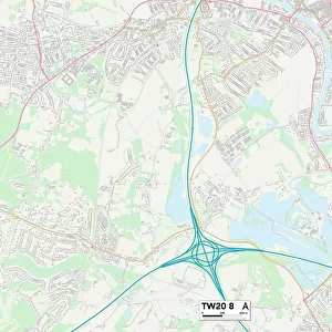
Spelthorne TW19 5 Map
Postcode Sector Map of Spelthorne TW19 5
Media ID 19982236
Acacia Avenue Brookside Avenue Coppice Drive Fairfield Road Friary Road Grange Close High Street Hill View Road Nursery Way Old School Court Park Avenue Riverside Spelthorne St Andrews Close Staines Road Station Road The Avenue The Drive The Embankment The Green Vicarage Lane Wharf Road Whitehall Lane Windsor Road Harcourt
FEATURES IN THESE COLLECTIONS
> Map Marketing
> Postcode Sector Maps
> TW - Twickenham
> Animals
> Mammals
> Muridae
> House Mouse
> Arts
> Artists
> H
> John Hillers
> Arts
> Artists
> H
> John Hills
> Arts
> Portraits
> Pop art gallery
> Street art portraits
> Europe
> United Kingdom
> Scotland
> Fife
> St Andrews
> Maps and Charts
> Related Images
MADE IN AUSTRALIA
Safe Shipping with 30 Day Money Back Guarantee
FREE PERSONALISATION*
We are proud to offer a range of customisation features including Personalised Captions, Color Filters and Picture Zoom Tools
SECURE PAYMENTS
We happily accept a wide range of payment options so you can pay for the things you need in the way that is most convenient for you
* Options may vary by product and licensing agreement. Zoomed Pictures can be adjusted in the Cart.