Home > Europe > United Kingdom > Scotland > Dumfries and Galloway > Wigtown
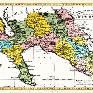
Wigtownshire DG8 9 Map

![]()
Wall Art and Photo Gifts from Map Marketing
Wigtownshire DG8 9 Map
Postcode Sector Map of Wigtownshire DG8 9
Media ID 19968412
Bank Street Bowling Green Road Braehead Church Lane Church Street Commercial Street Creek Road Curlew Close Harbour Road High Street Hillhead Jubilee Terrace Lovers Walk Main Street Mill Lane New Road Sea View Seaview Terrace South Street Southfield Lane Station Road The Orchard The Square Wigtownshire Seaview Wigtown
FEATURES IN THESE COLLECTIONS
> Map Marketing
> Postcode Sector Maps
> DG - Dumfries
> Arts
> Portraits
> Pop art gallery
> Street art portraits
> Europe
> United Kingdom
> Scotland
> Dumfries and Galloway
> Monreith
> Europe
> United Kingdom
> Scotland
> Dumfries and Galloway
> Wigtown
> Europe
> United Kingdom
> Scotland
> Wigtownshire
> Maps and Charts
> Related Images
MADE IN AUSTRALIA
Safe Shipping with 30 Day Money Back Guarantee
FREE PERSONALISATION*
We are proud to offer a range of customisation features including Personalised Captions, Color Filters and Picture Zoom Tools
SECURE PAYMENTS
We happily accept a wide range of payment options so you can pay for the things you need in the way that is most convenient for you
* Options may vary by product and licensing agreement. Zoomed Pictures can be adjusted in the Cart.