Home > Europe > United Kingdom > England > Devon > High Bray
Worcester WR7 4 Map

![]()
Wall Art and Photo Gifts from Map Marketing
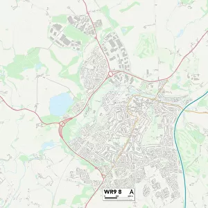
Worcester WR7 4 Map
Postcode Sector Map of Worcester WR7 4
Media ID 19982720
Apple Tree Close Appletree Lane Bourne Close Bramley Close Bray Close Brecon Close Bredon Close Chapel Lane Chestnut Lane Church Close Church Lane Church Road Churchill College Road Croft Road Devon Close Evesham Road High Street Holt Close Laxton Close Manor Court Manor Farm Meadow Close Mill Lane Newton Close Old Hill Orchard Mead Park Crescent Pear Tree Way Pepper Street Pershore Road Radford Road Rock Hill Rogers Lane Ross Crescent Sands Road School Lane Simons Close Station Close Stonepit Lane Towns End Windmill Hill Windmill Lane Worcester Bouts Claverton Crowle Hill Farm Kington Radford
FEATURES IN THESE COLLECTIONS
> Map Marketing
> Postcode Sector Maps
> WR - Worcester
> Animals
> Birds
> Owls
> Little Owl
> Animals
> Birds
> Owls
> Related Images
> Animals
> Mammals
> Muridae
> House Mouse
> Animals
> Mammals
> Muridae
> Little Wood Mouse
> Arts
> Artists
> F
> Newton Fielding
> Arts
> Portraits
> Pop art gallery
> Street art portraits
> Europe
> United Kingdom
> England
> Devon
> Church Green
> Europe
> United Kingdom
> England
> Devon
> High Bray
> Europe
> United Kingdom
> England
> Devon
> Newton Abbot
> Europe
> United Kingdom
> England
> Devon
> Related Images
MADE IN AUSTRALIA
Safe Shipping with 30 Day Money Back Guarantee
FREE PERSONALISATION*
We are proud to offer a range of customisation features including Personalised Captions, Color Filters and Picture Zoom Tools
SECURE PAYMENTS
We happily accept a wide range of payment options so you can pay for the things you need in the way that is most convenient for you
* Options may vary by product and licensing agreement. Zoomed Pictures can be adjusted in the Cart.