Home > Aerial Photography > Related Images
Psg302 Technique for Vertical Or Plan Mapping Aerial Pho?

![]()
Wall Art and Photo Gifts from Mary Evans Picture Library
Psg302 Technique for Vertical Or Plan Mapping Aerial Pho?
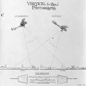
Psg302 Technique for Vertical Or Plan Mapping Aerial Photography Aerial Stereoscopy to Avoid Bad Results - Early Years of Aerial-Photography History - Instructions
Mary Evans Picture Library makes available wonderful images created for people to enjoy over the centuries
Media ID 18412928
© aviation-images.com / Mary Evans Picture Library
Aerial Photographs Aerial Photography Air To Ground Archive Archives Days Histories Olden Past Aerial Photos
FEATURES IN THESE COLLECTIONS
> Aerial Photography
> Related Images
> Mary Evans Prints Online
> Aviation Images
EDITORS COMMENTS
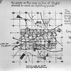
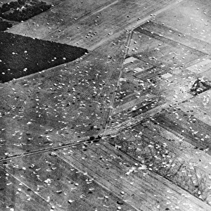
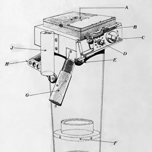
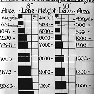
1. Title: "Psg302 Technique: A Historical Approach to Vertical or Plan Mapping Aerial Photography and Aerial Stereoscopy" 2.. This vintage photograph from the early years of aerial photography showcases the Psg302 Technique, a method used for vertical or plan mapping aerial photography and aerial stereoscopy. The image captures the intricate process of taking aerial photographs from an airplane, with the ground below in sharp focus and the airplane's wing and propeller visible in the foreground. Aerial photography, first developed in the late 1800s, has played a significant role in documenting the Earth's surface from an unique perspective. The Psg302 Technique was a crucial innovation in this field, allowing for accurate and detailed mapping of the ground, essential for various applications such as urban planning, agriculture, and military intelligence. The technique involved maintaining a constant altitude and camera angle, ensuring that the ground was photographed perpendicularly. This resulted in vertical images that could be used to create accurate topographic maps or stereoscopic pairs for three-dimensional analysis. The historical significance of this photograph lies not only in its depiction of an important technique in aerial photography but also in the reminder of the early challenges and innovations that shaped this field. The image transports us back to the olden days of aerial photography, a time when the technology was still new and the potential applications were just being discovered. This photograph is an archival treasure from the past, preserving a piece of history that continues to inspire and inform modern aerial photography and mapping techniques.
MADE IN AUSTRALIA
Safe Shipping with 30 Day Money Back Guarantee
FREE PERSONALISATION*
We are proud to offer a range of customisation features including Personalised Captions, Color Filters and Picture Zoom Tools
FREE COLORIZATION SERVICE
You can choose advanced AI Colorization for this picture at no extra charge!
SECURE PAYMENTS
We happily accept a wide range of payment options so you can pay for the things you need in the way that is most convenient for you
* Options may vary by product and licensing agreement. Zoomed Pictures can be adjusted in the Cart.