Home > Europe > United Kingdom > England > London > Sights > Piccadilly Circus
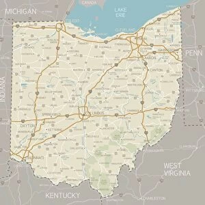
Map of central London with Piccadilly Circus at centre

![]()
Wall Art and Photo Gifts from Mary Evans Picture Library
Map of central London with Piccadilly Circus at centre
A map of the West End of London with Piccadilly Circus at its centre. Famous theatres, night spots, cinemas and hotels are marked with decorative labels and symbolic drawings. Date: 1950
Mary Evans Picture Library makes available wonderful images created for people to enjoy over the centuries
Media ID 14380620
© Illustrated London News Ltd/Mary Evans
Circus Maps Nightlife Piccadilly Tatler
FEATURES IN THESE COLLECTIONS
> Europe
> United Kingdom
> England
> London
> Art
> Entertainment
> Europe
> United Kingdom
> England
> London
> Art
> Theatre
> Europe
> United Kingdom
> England
> London
> Sights
> Piccadilly Circus
> Maps and Charts
> Related Images
EDITORS COMMENTS
1. Title: A Vibrant Nights' Haven: Central London's West End in the 1950s, with Piccadilly Circus at its Heart 2. Description: Step back in time to the 1950s and explore the bustling heart of Central London's West End, as depicted in this map print. Piccadilly Circus, a renowned London landmark, takes center stage, encircled by the area's rich tapestry of theatres, night spots, cinemas, and hotels. 3. Details: This beautifully preserved map, dated 1950, invites you on a journey through the West End's vibrant entertainment scene. Famous theatres, such as the Aldwych, Adelphi, and Prince of Wales, are marked with decorative labels and symbolic drawings, reflecting the area's rich theatrical heritage. 4. Nightlife and Entertainment: The map also highlights the area's thriving nightlife, with iconic venues like the Café de Paris, the Windmill Theatre, and the Palladium, all represented by distinctive symbols. These establishments were renowned for their entertainment offerings, drawing in crowds from far and wide. 5. Accommodations: For those seeking a place to rest after an evening of exploration, the map includes various hotels, such as the Cumberland, the Strand Palace, and the Savoy, ensuring a comfortable stay for visitors. 6. Historical Context: This map offers a fascinating glimpse into London's post-war history, showcasing the city's resilience and its dedication to maintaining its status as a global cultural hub. The map's intricate details and decorative elements serve as a testament to the allure and charm of Central London's West End during this era. 7. Conclusion: This map print of Central London's West End in the 1950s, with Piccadilly Circus at its heart, offers a unique perspective on the area's rich history and vibrant entertainment scene. It invites us to explore the past and appreciate the enduring allure of this iconic part of the city.
MADE IN AUSTRALIA
Safe Shipping with 30 Day Money Back Guarantee
FREE PERSONALISATION*
We are proud to offer a range of customisation features including Personalised Captions, Color Filters and Picture Zoom Tools
SECURE PAYMENTS
We happily accept a wide range of payment options so you can pay for the things you need in the way that is most convenient for you
* Options may vary by product and licensing agreement. Zoomed Pictures can be adjusted in the Cart.