Home > Asia > India > Lucknow
Map of India

![]()
Wall Art and Photo Gifts from Mary Evans Picture Library
Map of India
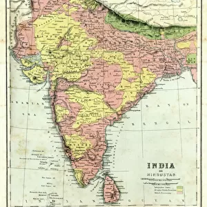
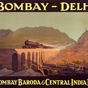
A map of India in 1857 (the year of the Indian Mutiny) showing the kingdoms, states and provinces; the principal rivers; the bays and gulfs; and the principal cities, towns and forts, including Delhi, Meerut, Agra, Cawnpore, Lucknow and Benares. Date: 1857
Mary Evans Picture Library makes available wonderful images created for people to enjoy over the centuries
Media ID 7237511
© Mary Evans Picture Library 2015 - https://copyrighthub.org/s0/hub1/creation/maryevans/MaryEvansPictureID/10498027
FEATURES IN THESE COLLECTIONS
> Maps and Charts
> India
EDITORS COMMENTS
This map print depicts India as it appeared in 1857, a pivotal year in the country's history marked by the Indian Mutiny. The intricate details of the map reveal the political landscape of the region during that time, with the various kingdoms, states, and provinces clearly demarcated. The Principal Rivers, such as the Indus, Ganges, and Brahmaputra, flow gracefully through the map, adding to its visual appeal. The map also highlights the major bays and gulfs, including the Bay of Bengal and the Arabian Sea, which played crucial roles in India's maritime history. The principal cities, towns, and forts are also marked, with Delhi, Meerut, Agra, Cawnpore, Lucknow, and Benares prominently displayed. These cities were significant centers of power and culture during the 1850s, and their inclusion in the map underscores their historical importance. The Indian Mutiny, also known as the Sepoy Mutiny, was a major uprising against the British East India Company's rule in India. The mutiny began in Meerut in May 1857 and quickly spread to other parts of the country. The rebellion was eventually suppressed, but it marked the beginning of the end of the Company's rule and paved the way for the British Crown to take direct control of India. This map offers a fascinating glimpse into India's past, providing valuable insights into the political and geographical landscape of the region during a time of great upheaval. Its intricate details and historical significance make it an invaluable resource for scholars, historians, and anyone interested in the rich history of India and Asia.
MADE IN AUSTRALIA
Safe Shipping with 30 Day Money Back Guarantee
FREE PERSONALISATION*
We are proud to offer a range of customisation features including Personalised Captions, Color Filters and Picture Zoom Tools
SECURE PAYMENTS
We happily accept a wide range of payment options so you can pay for the things you need in the way that is most convenient for you
* Options may vary by product and licensing agreement. Zoomed Pictures can be adjusted in the Cart.