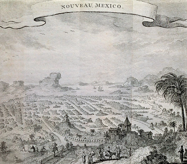
Map of New Mexico. 17th century
![]()

Wall Art and Photo Gifts from Mary Evans Picture Library
Map of New Mexico. 17th century
Map of New Mexico. View of the city in 1625, after an engraving of 1754
Mary Evans Picture Library makes available wonderful images created for people to enjoy over the centuries
Media ID 14319495
© Thaliastock / Mary Evans
EDITORS COMMENTS
This 17th century print depicts a general view of the city of New Mexico, as it may have appeared around the year 1625. The map, an engraving from 1754, offers a fascinating glimpse into the history and landscape of this region during the early modern era. New Mexico, a part of the larger Mexican territories in North America, was a significant area of exploration and colonization during the 16th and 17th centuries. This map reflects the geographical knowledge of the time, with the city at the heart of the image, surrounded by the vast expanse of the desert landscape. The city itself is shown with a grid-like layout, typical of Spanish colonial planning, and is dotted with various structures, including a church or cathedral, and what appear to be residential buildings. The map also includes the names of some of the major rivers and mountains in the area, written in Latin script. These labels provide valuable information about the topography and geography of New Mexico, which was essential for the exploration and settlement of the region. The print also offers a glimpse into the people who inhabited this area during the 17th century. Indigenous peoples, likely Puebloan or Apache, are depicted in the surrounding landscape, engaged in various activities such as farming, hunting, and gathering. The presence of these people highlights the complex and interconnected nature of the early colonial societies in the Americas, and the ongoing interactions between Europeans, Africans, and indigenous peoples. Overall, this 17th century map of New Mexico is a valuable historical artifact, offering insights into the geography, people, and history of this region during a pivotal period in American history.
MADE IN AUSTRALIA
Safe Shipping with 30 Day Money Back Guarantee
FREE PERSONALISATION*
We are proud to offer a range of customisation features including Personalised Captions, Color Filters and Picture Zoom Tools
SECURE PAYMENTS
We happily accept a wide range of payment options so you can pay for the things you need in the way that is most convenient for you
* Options may vary by product and licensing agreement. Zoomed Pictures can be adjusted in the Cart.


