Home > Europe > Russia > Maps
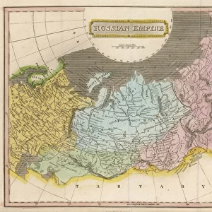
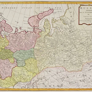
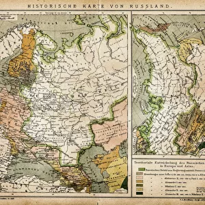
Map / Russia / Siberia C1860

![]()
Wall Art and Photo Gifts from Mary Evans Picture Library
Map / Russia / Siberia C1860
Siberia and Eastern Russia Date: circa 1860
Mary Evans Picture Library makes available wonderful images created for people to enjoy over the centuries
Media ID 14272315
© Mary Evans Picture Library
FEATURES IN THESE COLLECTIONS
> Maps and Charts
> Early Maps
EDITORS COMMENTS
1. Title: "Exploring the Uncharted Territories of Siberia: A Historical Map from Circa 1860" This map print, dated circa 1860, offers an intriguing glimpse into the largely unexplored territories of Siberia and Eastern Russia during the 19th century. The map, which covers a vast expanse of land from the Arctic Ocean in the north to the Pacific Ocean in the east, and from the Ural Mountains in the west to the Sea of Okhotsk in the east, was produced during a time when European powers were actively expanding their empires and exploring new lands. Siberia, a region that stretches over 13 time zones and covers more than one-eighth of the Earth's land area, was a land of mystery and intrigue for Europeans. The map reveals the limited knowledge Europeans had of this vast and remote region, with large areas marked as "terra incognita" or "unknown territory." The map also highlights the major geographical features of Siberia, including the Ural Mountains, the Siberian rivers, and the vast expanses of taiga forest. The map also reveals the political divisions of the Russian Empire at the time, with the territories of Siberia and Eastern Russia divided into various administrative regions. The map also includes an inset map of Europe, providing context for the location of Siberia in relation to the rest of the continent. This historical map is a testament to the spirit of exploration and discovery that characterized the 19th century. It invites us to imagine the challenges and adventures faced by the explorers and settlers who ventured into the unknown territories of Siberia and Eastern Russia, and to appreciate the role that maps played in shaping our understanding of the world. Whether you are a history buff, a cartography enthusiast, or simply someone with a curiosity for the world and its past, this map print is sure to captivate and inspire you. Its intricate details, historical significance, and beautiful design make it a must-have for any collection.
MADE IN AUSTRALIA
Safe Shipping with 30 Day Money Back Guarantee
FREE PERSONALISATION*
We are proud to offer a range of customisation features including Personalised Captions, Color Filters and Picture Zoom Tools
SECURE PAYMENTS
We happily accept a wide range of payment options so you can pay for the things you need in the way that is most convenient for you
* Options may vary by product and licensing agreement. Zoomed Pictures can be adjusted in the Cart.