Home > Maps and Charts > Early Maps
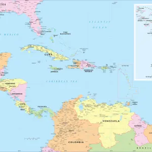
Map West Indies

![]()
Wall Art and Photo Gifts from Mary Evans Picture Library
Map West Indies
The European powers are competing who can grab the greater portion of these islands : the French and British are doing better than the Spanish and Dutch... Date: 1827
Mary Evans Picture Library makes available wonderful images created for people to enjoy over the centuries
Media ID 14113529
© Mary Evans Picture Library
1827 Competing Grab Greater Indies Maps Portion Powers
EDITORS COMMENTS
Map of the West Indies, 1827: A Testament to European Competition and Colonial Expansion This map print, dated 1827, provides a glimpse into the intense competition among European powers vying for control of the Caribbean islands, collectively known as the West Indies. The map reveals the vast extent of European influence in the region, with the French and British dominions standing out as the most prominent. The West Indies, a collection of over 700 islands and cays, had long been a coveted prize for European powers due to their rich natural resources, including sugar, spices, and timber. The Spanish, Dutch, French, and British all sought to establish colonies and claim the greatest portion of these islands for themselves. By the mid-19th century, the Spanish and Dutch had been largely pushed out of the region, leaving the French and British as the dominant European powers. The map illustrates the extent of their territorial gains, with the British colonies stretching from the Bahamas in the north to Trinidad in the south, and the French colonies encompassing the islands of Martinique, Guadeloupe, and Haiti, among others. This map serves as a poignant reminder of the European colonial era and the fierce competition that characterized it. The West Indies became a battleground for power and influence, with each European power seeking to establish a strong presence and secure valuable resources. The map also highlights the profound impact of European colonialism on the Caribbean region, shaping its political, economic, and cultural landscape for generations to come.
MADE IN AUSTRALIA
Safe Shipping with 30 Day Money Back Guarantee
FREE PERSONALISATION*
We are proud to offer a range of customisation features including Personalised Captions, Color Filters and Picture Zoom Tools
SECURE PAYMENTS
We happily accept a wide range of payment options so you can pay for the things you need in the way that is most convenient for you
* Options may vary by product and licensing agreement. Zoomed Pictures can be adjusted in the Cart.


![SR - Sandown Station (Modernisation - Proposed Alterations to Station Buildings [N. D]](/sq/229/sr-sandown-station-modernisation-proposed-19007229.jpg.webp)