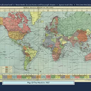
Home > Maps and Charts > World
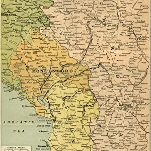
Map of Yugoslavia by G. H. Davis

![]()
Wall Art and Photo Gifts from Mary Evans Picture Library
Map of Yugoslavia by G. H. Davis
Map of Yugoslavia, Britains latest ally in the Second World War: her defensive mountains and valleys. Mountainous Yugoslavia, her valleys and airfields. Date: 1941
Mary Evans Picture Library makes available wonderful images created for people to enjoy over the centuries
Media ID 14133135
© Illustrated London News Ltd/Mary Evans
1941 Adriatic Airfields Allies Ally Davis Defensive Difficult Mountainous Rough Rugged Terrain Valleys Yugoslavia
FEATURES IN THESE COLLECTIONS
> Europe
> Related Images
> Maps and Charts
> Early Maps
> Maps and Charts
> World
EDITORS COMMENTS
This map print, titled "Map of Yugoslavia, Britains latest ally in the Second World War: her defensive mountains and valleys," is a testament to the complex geography and historical significance of Yugoslavia during the tumultuous years of the 1940s. Produced by renowned cartographer G.H. Davis in 1941, this map offers a unique perspective on a region that played a pivotal role in European history during the Second World War. The map highlights the rugged and mountainous terrain that characterizes much of Yugoslavia, with the Dinaric Alps dominating the eastern and southern borders. The Adriatic Sea, with its strategic ports and airfields, is also prominently featured. The rough and difficult terrain presented significant challenges for military operations, making it a formidable defensive position for Yugoslavia and her allies. At the time of this map's creation, Yugoslavia had recently joined the Allied forces in the Second World War, adding an important eastern European ally to the coalition. The map underscores the defensive value of Yugoslavia's mountainous terrain and its strategic airfields, which would have been crucial in the defense against Axis powers. As we examine this historical map, we are transported back in time to a pivotal moment in European history. The intricate details and meticulous labeling serve as a reminder of the complex geopolitical landscape of the time and the strategic importance of Yugoslavia in the Allied war effort. This map is not only a beautiful piece of cartographic art but also an essential historical document that offers valuable insights into the geography and politics of a region that continues to shape European history.
MADE IN AUSTRALIA
Safe Shipping with 30 Day Money Back Guarantee
FREE PERSONALISATION*
We are proud to offer a range of customisation features including Personalised Captions, Color Filters and Picture Zoom Tools
SECURE PAYMENTS
We happily accept a wide range of payment options so you can pay for the things you need in the way that is most convenient for you
* Options may vary by product and licensing agreement. Zoomed Pictures can be adjusted in the Cart.