Fraud Blocker Skip to main content

Home > Maps and Charts > World

Mercator / World Map / 1587

Mercator  /  World Map  /  1587
Sold 2
In Stock
We accept all major credit cards

Mary Evans Picture Library Photo Prints and Wall Art

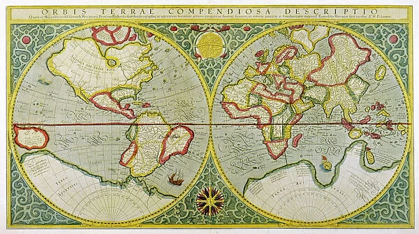
Mercator / World Map / 1587

A map of the world by Gerhard Mercator. Mary Evans Picture Library makes available wonderful images created for people to enjoy over the centuries. © Mary Evans Picture Library 2015 - https://copyrighthub.org/s0/hub1/creation/maryevans/MaryEvansPictureID/10025620

Media ID 580904

1587 Gerhard Maps Mercator

FEATURES IN THESE COLLECTIONS

> Maps and Charts > Early Maps

> Maps and Charts > Related Images

> Maps and Charts > World

> Mary Evans Prints Online > Maps

SECURE PAYMENTS
We happily accept a wide range of payment options so you can pay for the things you need in the way that is most convenient for you

MADE IN AUSTRALIA
Safe Shipping with 30 Day Money Back Guarantee

FREE PERSONALISATION
We are proud to offer a range of customisation including Cropping, Captions, and Filters. Zoom Cropping can be adjusted in the Basket.


EDITORS COMMENTS

This image showcases the intricately detailed and historically significant 1587 World Map by the renowned cartographer Gerhard Mercator. One of the most influential maps in history, Mercator's map is a testament to the advancements in cartography during the Renaissance period. Mercator, a Flemish cartographer, created this map as part of his atlas "Atlas sive Cosmographiae Universales," published in Duisburg, Germany. This map was the first to use Mercator's new projection, which became the standard for nautical charts and navigational maps for centuries. The Mercator projection, with its rectangular shape and constant scale along the meridians, allowed sailors to maintain a consistent course and navigate more accurately than ever before. The map is adorned with elaborate decorative elements, including intricate cartouches, coats of arms, and elaborate title inscriptions. The map's border features various scenes from biblical history, as well as depictions of the four continents known at the time: Europe, Asia, Africa, and America. The map's meticulous detail and innovative projection revolutionized cartography and played a crucial role in the Age of Discovery. It allowed explorers and navigators to chart new territories and expand European knowledge of the world. This historic map is not only a beautiful work of art but also a significant piece of historical and scientific importance. The Mary Evans Picture Library is proud to offer this high-resolution image of Gerhard Mercator's 1587 World Map for researchers, educators, and anyone interested in the history of cartography, exploration, or the world as it was known during the Renaissance period.


Framed Prints

Discover the captivating allure of history with our exquisite selection of Framed Prints from the Media Storehouse range. This particular piece showcases the iconic "Mercator / World Map / 1587" by Mary Evans Picture Library from Mary Evans Prints Online. Gerhard Mercator's masterpiece, a testament to cartographic innovation, presents a captivating and intricately detailed representation of the world as it was known in 1587. Each print is meticulously framed to preserve and enhance the rich, vibrant colors and intricate details of the map. Bring the fascination of history into your home or office with this stunning addition to your decor.


Photo Prints

Discover the captivating beauty of history with our exquisite selection of Mercator World Map prints from the Media Storehouse range, exclusively available through Mary Evans Picture Library. This iconic map, created by the renowned Flemish cartographer Gerhard Mercator in 1587, represents a pivotal moment in the exploration and understanding of the world. Each print showcases intricate detail and vibrant colors, transporting you back in time to the age of discovery. Bring a piece of history into your home or office and adorn your walls with this timeless masterpiece.


Poster Prints

Discover the captivating allure of history with our exquisite selection of Mercator World Map Poster Prints from the Media Storehouse range. This stunning reproduction, sourced from the esteemed Mary Evans Picture Library, showcases the iconic 1587 map by Gerhard Mercator. Known for his groundbreaking cartography, Mercator's map is a testament to the rich exploration era. Adorn your walls with this captivating piece and transport yourself back in time, as you delve into the wonders of geography and the history of cartography. Each print is meticulously crafted using high-quality materials, ensuring a vibrant, long-lasting display. Elevate your space with this intriguing and educational addition to your décor.


Jigsaw Puzzles

Discover the wonders of the world with our exquisite collection of jigsaw puzzles from Media Storehouse. Feast your eyes on this captivating Mercator/World Map/1587, an intricately detailed representation of the world as it was known during the late 16th century. This beautiful puzzle, sourced from the Mary Evans Picture Library through Mary Evans Prints Online, features the iconic map created by Flemish cartographer Gerhard Mercator in 1587. Recreate this historical masterpiece and embark on an educational and entertaining journey through time. With countless intricately cut pieces, this puzzle promises hours of captivating fun for puzzle enthusiasts of all ages.

diamond
Made With High Grade Materials
thumb_up
Professional Quality Finish
package_2
Carefully Packed To Aid Safe Arrival

You May Also Like


Al-Idrisis world map, 1154Al-Idrisis world map, 1154
Add to Basket
17th century world map17th century world map
Add to Basket
Fra Mauro map (1460). The Fra Mauro Map orientation (South at the top). is consideredFra Mauro map (1460). The Fra Mauro Map orientation (South at the top). is considered
Add to Basket
Map Of Fra Mauro, 1457 - 1459. From The Book Life Of Christopher Columbus By Clements R. Markham Published 1892Map Of Fra Mauro, 1457 - 1459. From The Book Life Of Christopher Columbus By Clements R. Markham Published 1892
Add to Basket
Old Map of the World on Mercators Projection 1851 Showing the Voyages of Captain Cook by John TallisOld Map of the World on Mercators Projection 1851 Showing the Voyages of Captain Cook by John Tallis
Add to Basket
Atlantis / MapAtlantis / Map
Add to Basket
Flat Earth map of the world showing it to be a planeFlat Earth map of the world showing it to be a plane
Add to Basket
Elysee Palace - mapElysee Palace - map
Add to Basket
Overton World Map / 1670Overton World Map / 1670
Add to Basket
Depiction of a flat planet EarthDepiction of a flat planet Earth
Add to Basket
World Known to PtolemyWorld Known to Ptolemy
Add to Basket
Map of Ancient GreeceMap of Ancient Greece
Add to Basket

Gallery Wall Inspiration

Map / Asia / India C1870
Map / Asia / India C1850
Map of Ancient Greece
World Map Empire McVitie
Maps / Australia / New Zea
Map / Europe / Germany 1871
Maps / World / Eratosthenes
Maps / Australia 1854
World Known to Ptolemy
Map / Europe / France / Paris
Map / Europe / Poland 1772
London Map 1560 / Aggas
Overton World Map / 1670
WORLD MAP / 1897
Map of St Pauls and area
Map / Europe / Greece / Ford
Map /s America / Brazil 16C
Maps / Americas 1540
Maps / World / Ptolemy 2Ad
Mercator / World Map / 1587
Map / Britain / Saxon Period
Atlantis / Map
Map / Russia / Siberia 1764
Map / China / Tibet 1749
Map / Europe / Germany 1827
Map / England & Wales 1810
Map / England & Wales 9C

Discover Our Collections


MapsMaps
View Collection
Early MapsEarly Maps
View Collection
Maps and Charts Related ImagesMaps and Charts Related Images
View Collection
WorldWorld
View Collection


© Copyright Media Storehouse, All Rights Reserved 2003 - 2024
Facebook     Pinterest     Card Payments     Reviews IO