Home > Animals > Mammals > Muridae > Fortior
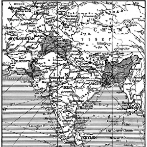
Map of India and Pakistan

![]()
Wall Art and Photo Gifts from Mary Evans Picture Library
Map of India and Pakistan
India and Pakistan, showing States, and areas allocated to neither new country, 1948 Date: 1948
Mary Evans Picture Library makes available wonderful images created for people to enjoy over the centuries
Media ID 7404075
© Mary Evans Picture Library 2015 - https://copyrighthub.org/s0/hub1/creation/maryevans/MaryEvansPictureID/10474698
FEATURES IN THESE COLLECTIONS
> Animals
> Mammals
> Muridae
> Fortior
> Asia
> India
> Related Images
> Asia
> Pakistan
> Related Images
> Maps and Charts
> India
> Maps and Charts
> Related Images
> Mary Evans Prints Online
> National Archives
EDITORS COMMENTS
1. Title: "Divided Terrains: A Historical Map of India and Pakistan in 1948" This evocative black-and-white map print, dated 1948, offers a glimpse into the complex geopolitical landscape of South Asia following the partition of India and Pakistan. The map meticulously outlines the newly formed nations, with India to the west and Pakistan to the east, separated by the thick, bold line of the border. The map also delineates the princely states, which chose to join either India or Pakistan, and those that remained independent. These states, scattered throughout the region, added another layer of complexity to the partition process. The map further highlights the areas that were not allocated to either country, such as the princely state of Jammu and Kashmir, which remains a contested territory between India and Pakistan to this day. The map serves as a poignant reminder of the tumultuous history of the Indian subcontinent in the 1940s. The partition of India and Pakistan, which took place on August 15, 1947, was a result of decades of political and religious tensions between the two communities. The process of partition was fraught with violence and displacement, with millions of Hindus and Sikhs leaving Pakistan for India, and Muslims moving in the opposite direction. This map, with its intricate details and historical significance, offers a unique perspective on a pivotal moment in world history. It is a testament to the enduring importance of understanding the complexities of geopolitics and the role that maps play in shaping our collective memory. Whether used as a conversation starter, a decorative piece, or a tool for historical research, this map is a valuable addition to any collection.
MADE IN AUSTRALIA
Safe Shipping with 30 Day Money Back Guarantee
FREE PERSONALISATION*
We are proud to offer a range of customisation features including Personalised Captions, Color Filters and Picture Zoom Tools
SECURE PAYMENTS
We happily accept a wide range of payment options so you can pay for the things you need in the way that is most convenient for you
* Options may vary by product and licensing agreement. Zoomed Pictures can be adjusted in the Cart.