Home > Europe > United Kingdom > England > Maps
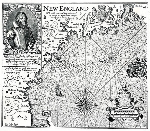
Map of New England 1610
![]()

Wall Art and Photo Gifts from Mary Evans Picture Library
Map of New England 1610
A coastal map of New England, with a portrait of Captain John Smith in the upper left corner. Date: 1610
Mary Evans Picture Library makes available wonderful images created for people to enjoy over the centuries
Media ID 23089754
© Mary Evans Picture Library
Corner Explorer Facsimile Smith Upper
FEATURES IN THESE COLLECTIONS
> Europe
> United Kingdom
> England
> Maps
> Maps and Charts
> World
> Mary Evans Prints Online
> New Images August 2021
> North America
> Related Images
EDITORS COMMENTS
1. Title: A Glimpse into the Early Exploration of New England: A 1610 Map and the Portrait of Captain John Smith This print showcases an intricately detailed map of New England from the year 1610, accompanied by a captivating portrait of the renowned English explorer, Captain John Smith. The map, with its rich coastal topography, offers a fascinating glimpse into the early cartographic understanding of New England during the 17th century. The map, a testament to the era's exploratory spirit, is adorned with various annotations, notations, and symbols, reflecting the incomplete yet meticulous knowledge of the region's geography. The coastline is marked with the names of several settlements, rivers, and bays, including the Massachusetts Bay, Plymouth Bay, and the Connecticut River. In the upper left corner, the portrait of Captain John Smith, an influential figure in the early history of North America, adds an intriguing dimension to the print. Smith, an English soldier, cartographer, and writer, is best known for his role in the establishment of the Jamestown Settlement in Virginia and his contributions to the mapping of the Chesapeake Bay. His presence in this map, which primarily focuses on New England, suggests his extensive exploratory endeavors and the interconnectedness of the New World's various territories during this period. The combination of the detailed map and the portrait of Captain John Smith offers a unique perspective into the early exploration of New England during the 17th century. This print is an essential addition to any collection focusing on cartography, early American history, or the age of exploration.
MADE IN AUSTRALIA
Safe Shipping with 30 Day Money Back Guarantee
FREE PERSONALISATION*
We are proud to offer a range of customisation features including Personalised Captions, Color Filters and Picture Zoom Tools
SECURE PAYMENTS
We happily accept a wide range of payment options so you can pay for the things you need in the way that is most convenient for you
* Options may vary by product and licensing agreement. Zoomed Pictures can be adjusted in the Cart.


