Home > Europe > United Kingdom > England > Maps
MAP / BERKSHIRE 18C

![]()
Wall Art and Photo Gifts from Mary Evans Picture Library
MAP / BERKSHIRE 18C
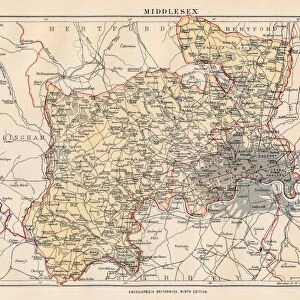
Map of Berkshire Date: 18th century
Mary Evans Picture Library makes available wonderful images created for people to enjoy over the centuries
Media ID 20153831
© Bubblepunk
FEATURES IN THESE COLLECTIONS
> Europe
> United Kingdom
> England
> Berkshire
> Related Images
> Europe
> United Kingdom
> England
> Maps
> Maps and Charts
> Related Images
> Mary Evans Prints Online
> New Images July 2020
EDITORS COMMENTS
This exquisite 18th century map, titled "Berkshire," offers a fascinating glimpse into the geographical knowledge and cartographic skills of the time. Printed in the 18th century from an original by John Rocque, this map meticulously depicts the English county of Berkshire, located in the south-central part of England. The intricate detailing of the map is evident in the representation of roads, rivers, towns, and villages, each labeled with great care. The map also includes illustrations of notable landmarks such as Windsor Castle, the royal residence, and the ancient abbey at Abingdon. The map's antique charm lies not only in its historical significance but also in its aesthetic appeal. The use of elegant cartouches, intricate borders, and an inset map of London add to the map's ornamental beauty. The map's scale of 1 inch to 1 mile allows for a detailed exploration of the county, making it an invaluable resource for historians, genealogists, and anyone with an interest in the history of England. The map's age also adds to its allure, as it provides a window into the past, revealing the county's topography and settlement patterns as they existed over 250 years ago. The map's condition is excellent, with minimal wear and tear, ensuring that its intricate details remain clear and visible. This map is not only a valuable addition to any collection of antique maps but also a captivating piece of historical art. In conclusion, this 18th century map of Berkshire is a testament to the cartographic skills and knowledge of the time, providing a detailed and intriguing glimpse into the history of England. Its antique charm, historical significance, and intricate detailing make it a must-have for anyone with an interest in history, cartography, or the English countryside.
MADE IN AUSTRALIA
Safe Shipping with 30 Day Money Back Guarantee
FREE PERSONALISATION*
We are proud to offer a range of customisation features including Personalised Captions, Color Filters and Picture Zoom Tools
SECURE PAYMENTS
We happily accept a wide range of payment options so you can pay for the things you need in the way that is most convenient for you
* Options may vary by product and licensing agreement. Zoomed Pictures can be adjusted in the Cart.