Home > Europe > France > Maps
MAP / EUROPE / FRANCE 12C

![]()
Wall Art and Photo Gifts from Mary Evans Picture Library
MAP / EUROPE / FRANCE 12C
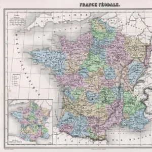
Map of France showing English possessions between 1165 and 1453. Date: 12th-15th century
Mary Evans Picture Library makes available wonderful images created for people to enjoy over the centuries
Media ID 20146889
© Bubblepunk
1165 12th 1453 Maps Possessions 15th
FEATURES IN THESE COLLECTIONS
> Mary Evans Prints Online
> New Images July 2020
EDITORS COMMENTS
This map print from the 12th to 15th century depicts the territorial reach of English possessions in France during a pivotal period in European history. The intricately detailed map, available from Mary Evans Prints Online, offers a glimpse into the complex political landscape of Europe during the Middle Ages. The map, titled "Map of France showing English possessions between 1165 and 1453," provides a visual representation of the English dominions in France, which extended beyond the Duchy of Normandy and included territories such as Anjou, Poitou, and Gascony. The map also highlights key cities and geographical features, providing valuable context for understanding the strategic importance of these territories. During this time, England's influence in France was significantly shaped by the Angevin dynasty, which ruled both the English and Angevin territories. The map reflects the dynamic nature of medieval politics, as English control over these territories fluctuated throughout the 13th and 14th centuries due to various conflicts and alliances. The map serves as an essential resource for scholars and history enthusiasts, offering insights into the complex web of political relationships and territorial claims that characterized medieval Europe. Its meticulous detail and historical significance make it an invaluable addition to any collection of historical maps or European studies.
MADE IN AUSTRALIA
Safe Shipping with 30 Day Money Back Guarantee
FREE PERSONALISATION*
We are proud to offer a range of customisation features including Personalised Captions, Color Filters and Picture Zoom Tools
SECURE PAYMENTS
We happily accept a wide range of payment options so you can pay for the things you need in the way that is most convenient for you
* Options may vary by product and licensing agreement. Zoomed Pictures can be adjusted in the Cart.