Home > Europe > United Kingdom > England > Norfolk > Downham Market
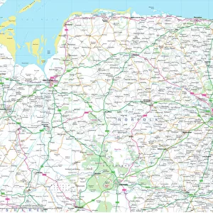
1840s Victorian Map of Norfolk

![]()
Wall Art and Photo Gifts from Mary Evans Picture Library
1840s Victorian Map of Norfolk
Mary Evans Picture Library makes available wonderful images created for people to enjoy over the centuries
Media ID 32350854
© The Keasbury-Gordon Photograph Archive / Mary Evans
1840s Cromer Downham Hunstanton Kings Lynn Norfolk Norwich Railways Thetford Yarmouth
FEATURES IN THESE COLLECTIONS
> Europe
> United Kingdom
> England
> Maps
> Europe
> United Kingdom
> England
> Norfolk
> Cromer
> Europe
> United Kingdom
> England
> Norfolk
> Downham Market
> Europe
> United Kingdom
> England
> Norfolk
> Great Yarmouth
> Europe
> United Kingdom
> England
> Norfolk
> Hunstanton
> Europe
> United Kingdom
> England
> Norfolk
> King's Lynn
> Europe
> United Kingdom
> England
> Norfolk
> King's Lynn
> Europe
> United Kingdom
> England
> Norfolk
> Norwich
> Europe
> United Kingdom
> England
> Norfolk
> Thetford
> Europe
> United Kingdom
> England
> Norwich
> Mary Evans Prints Online
> New Images July 2023
EDITORS COMMENTS
Step back in time with this stunning 1840s Victorian Map of Norfolk, a true treasure from the past. This vintage map showcases the intricate details and craftsmanship of cartography during the Victorian era, highlighting cities such as Norwich, Cromer, Kings Lynn, Hunstanton, Downham Market, Thetford, and Great Yarmouth.
The map not only serves as a geographical guide but also provides a glimpse into the history and development of Norfolk in the early 19th century. From bustling market towns to serene coastal villages, each corner of this county is beautifully illustrated on this Edwardian-era print.
Transport yourself to a bygone era as you explore the intricate railway lines that crisscross through Norfolk on this map. The railways were crucial lifelines for both transportation and trade during this period and played a significant role in shaping the landscape of England.
Whether you have roots in Norfolk or simply appreciate historical artifacts, this 1840s Victorian Map is sure to captivate your imagination. Display it proudly in your home or office to add a touch of old-world charm and sophistication. Let its rich history and timeless beauty transport you back to a simpler time when maps were cherished works of art.
MADE IN AUSTRALIA
Safe Shipping with 30 Day Money Back Guarantee
FREE PERSONALISATION*
We are proud to offer a range of customisation features including Personalised Captions, Color Filters and Picture Zoom Tools
SECURE PAYMENTS
We happily accept a wide range of payment options so you can pay for the things you need in the way that is most convenient for you
* Options may vary by product and licensing agreement. Zoomed Pictures can be adjusted in the Cart.